Final Class Project for Geology 20, "Field Geology",
taught by Robert Lopez.
Purpose: to compile a geologic map of the central area of Red Rock Canyon, locating the contacts between the main geologic formations, verify stratigraphy, and discover the structure of the area.
Conclusion: the purpose was achieved. A preliminary geologic map, stratigraphic column, and cross section was determined for roughly a 2.5 square mile area surrounding the Ricardo visitor's center.
Location of study area: The Ricardo Visitor's Center area of Red Rock Canyon State Park is located in Southern California, near the towns of Ridgecrest and Mojave, on the USGS Saltdale NW 7.5-minute quadrangle. The study area extended from roughly .8 mi south of the Visitor's Center to .6 mi north, and from .4 miles west to 1.5 miles east. See Figure 1 for the actual map of the area and inset map showing location within California.
Access and geography: The study area is roughly bisected by north/south running Highway 14, with Abbott Dr. running into the Visitor's Center. The area of the park east of Highway 14 is accessed via dirt roads and trails; west of the highway is accessed primarily through hiking trails.
Climate is essentially high desert, with little rainfall or vegetation. Topography includes badlands erosion, cuestas formed by thin basalt layers capping softer sedimentary layers, and numerous dry washes.
Previous work: Whistler has studied the area somewhat, and provides some information on the stratigraphy. Some earlier stratigraphic work appears on maps by Dibblee, but is not used in the present report.
The field work used in this report was conducted on May 13-15, 2005. The base map used was a portion the USGS Saltdale NW 7.5-minute quadrangle, printed using Topo! software.
Field techniques employed included sighting, triangulation, and leveling using a Brunton pocket transit, measurement of strike and dip (also using the Brunton), topographic inspection, and inspection of lithology.
Red Rock canyon is located at a uniquely interesting intersection of three geomorphic provinces of California: the Sierra Nevada, the Mojave, and the Basin and Range.
These three provinces are bounded by significant regional structures. The Garlock Fault (and the related El Paso Fault, bounding the south end of Red Rock Canyon) are left-lateral transform faults dividing the crustal extension area of the Basin and Range block from the stable Mojave block to its south, with a cumulative displacement of 48 to 64km (Smith, 1962; Chen and Moore, 1979). The Sierra Frontal system of normal faults divides the Basin and Range from the Sierra Nevada.
The central area of Red Rock Canyon consists of alternating layers of sedimentary beds, mostly stream and lake deposits, sometimes poorly consolidated, and volcanics, primarily two basalt flows and a layer of tuff breccia.
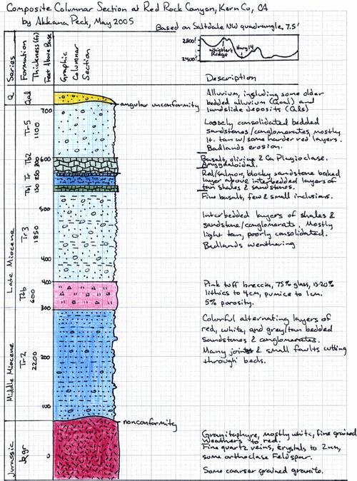
The area is underlain with the granitoids, of Jurassic origin, which comprise the El Paso mountains, at the southeast corner of the study area, and Red Rock Canyon gorge, just south of the study area. This is mostly very fine grained quartz granitophyre, white but weathering to dark red. It contains fine quartz veins, and quartz crystals up to 2mm, as well as some smaller (1mm or less) crystals of orthoclase feldspar. In addition, there are some more normal, much coarser, granites. Lithic descriptions are based on samples collected just south of the study area, in Red Rock Canyon gorge; the presence of the granitoid throughout the southeastern edge of the study area was inferred by distant inspection, topographic inspection and the model presented here of the area's structure.
Above the granitoids is a nonconformity of some 120 million years. The next rock present in the central Red Rock canyon area is one of the layers of the the middle Miocene sedimentary Ricardo formation, stream channel deposits denoted as Tr2. This thick (2200') layer consists of colorful alternating layers of red, white, and gray to tan bedded sandstones and some less well consolidated conglomerates. Many joints cut through the beds, and several faults (either normal, strike-slip, or a combination) offset the beds, and badland erosion creates "hoodoos" in which harder layers cap a column of softer beds.
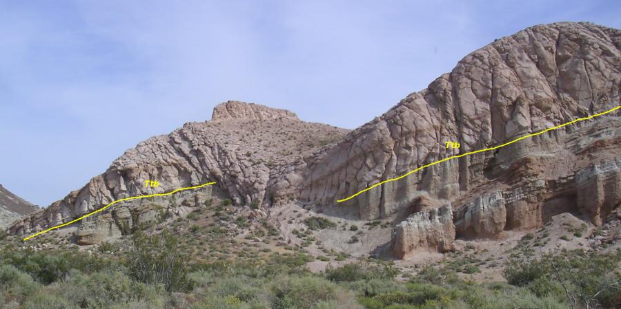
Above the Tr2 is a layer of lapilli ash tuff breccia, denoted Ttb. This unit is distinctive and recognizable due to its striking pink color. Samples at Station 1 on the accompanying map, located near where a small fault cuts the Ttb layer, consist of roughly 75% glass,
15-20% lithics up to 4cm, including pumice fragments up to 1cm, 5% porosity, and less than 5% crystals, mostly small feldspar crystals with some biotite mica. Also present is green celedonite, micaceous with flecks of light green and some red inclusions. Several layers of different color are visible in the tuff deposit, denoting at least two different ash falls.
Above the tuff (and adjacent to it in places due to faulting) is another sedimentary layer of the Ricardo formation, denoted Tr3, and identified primarily by its position between the Ttb tuff layer and the bottom Tb1 basalt layer. The Tr3 consists of interbedded layers
of shales, sandstones, siltstones and conglomerates, mostly light tan or grey, and poorly consolidated.
The Tr3 is capped by a very thin basalt flow, denoted Tb1. This basalt is fine grained with only a few small phenocrysts, and little olivine included, except for a small quantity which has been altered to red iddingsite crystals of 2-5mm. It was identified on the basis of being the lower of the two regional basalt flows. Some highly elongated plagioclase crystals are present, up to 6mm in length but less than 1mm in breadth. Some pyroxine augite is present. Vesicles in the basalt are very elongated, but flow direction is not as clearly shown as in the higher basalt layer, Tb2; however, both flows seem to have come from the south. The hardness of the Tb1 cap on top of the Tr3 layer makes cuestas with Tb1 as their top.
Above the Tb1/Tr3 cuesta is another cuesta consisting of another sedimentary Ricardo layer, Tr4, capped with another basalt flow, Tb2. Both of these layers were identified by their position above the preceding three layers.
The Tr4 layer is primarily interbedded layers of tan shales, sandstones, and conglomerates, not much different from the Tr3 and like it, easily eroded and forming talus slopes; but at the top of the Tr4 is a distinctive salmon-orange baked sandstone layer where the Tb2 layer contacts it. This baked layer is distinctive and recognizable from quite a distance, and identifies the Tr4 everywhere where it is overlain by Tb2 (which is the case throughout the study area). Near the north end of the study area, the interface between the Tr4 deposits and the Tb1 flow (Station 3 on accompanying map) contains
numerous opals and interbedded cherts, and was once used as an opal mine.
The Tb2 basalt, creating a cap for the Tr4, is much coarser and phenocryst rich than the lower Tb1. Samples from Station 3 include olivine crystals (red and yellow) up to 4mm, though 2mm and less are much more common; some samples have as much as 12% olivine. There are also smaller calcium plagioclase crystals. The basalt is highly amygdaloidal, with quartz chalcedony and green glauconite. Above the Tb2/Tr4 cuesta is a thick (1100-foot) layer of loosely consolidated Ricardo bedded sandstones and conglomerates, denoted Tr5. These are mostly light tan with some harder red beds interspersed. This area is highly susceptible to badlands erosion, and forms loose crumbly cliffs and gullies.
All of the preceding layers from the granitoids through the Tr5 have been tilted between 15 and 25 degrees, dipping generally west-northwest, and then experienced a period of erosion before quarternary fluvial sediments overlaid the whole area, now visible as thin loosely bedded alluvial layers (Qoal), flat-lying or dipping slightly (less than 10 degrees) east-southeast. Above this bedded Qoal older alluvium are younger non-bedded alluvial deposits, Qal, including one hillside dune deposit in the north-central part of the study area, and a few landslide deposits, Qls, especially arising from the Ttb tuff breccia area.
The structure of the area is largely a homocline, with strata dipping generally west-northwest, at angles ranging from about 5 to 25 degrees northwest but mostly centered around N 15 W. Dip angles range from 15 to 25 degrees.
The tilting of the Jurassic and Tertiary strata is most likely due to action on the El Paso fault (just south of the study area) which also caused the uplift of the El Paso mountains. Subsequent movement on local faults has not significantly changed this structure; no local folding seems to be present, and no fault motion seems to have taken place during the Quaternary.
The variable dip does not correlate well with stratum age: the steepest dip measured, 24 degrees, is near the center of the study area in the Tr3 and Tr2 where they adjoin the TTb tuff layer, but even younger Tr2 sediments farther east, close to the bottom of the layer,
dipped only 15 degrees, as did the Ttb layer. One might argue for continuous El Paso uplift throughout the Miocene deposition of the Ricardo, but the data from the present study do not seem to confirm this; more data would be needed.
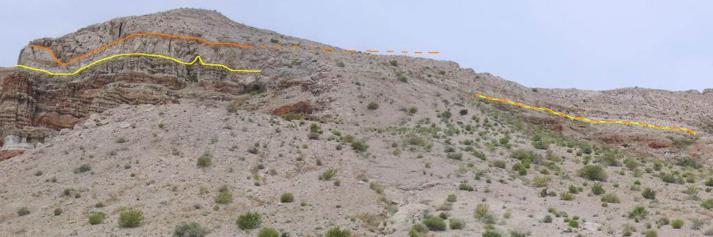
Numerous small faults cut through the area, especially adjacent to the Ttb exposures (see Figures 1 and 2).
Somewhat larger faults may be evidenced here (for example, is there one offsetting the Tb1 between its exposure at the north end of the study area and its southern exposures) but this would require further field investigation over a wider area, both to the north and south of the present study.
Too few data points were taken on the Qoal sediments to confirm whether Quaternary fault motion occurred, though the dipping of the Qoal at the east-center of the study area back toward the southeast tends to argue that the El Paso uplift has finished. However, that dip could have come from other causes, and is not conclusive. Again, more measurements would be needed.
Whistler, David P., 2005, A Field Guide to the Geology of Red Rock Canyon and the Southern El Paso Mountains, Mojave Desert, California (PDF), presented at the Annual Meeting of Western Association of Vertebrate Paleontologists.