Shallow Thoughts : : geology
Akkana's Musings on Open Source Computing and Technology, Science, and Nature.
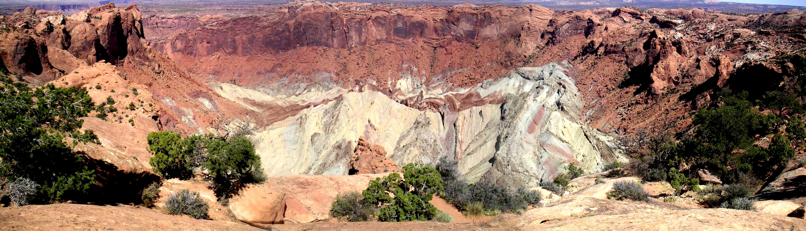
Sat, 29 Nov 2008
Kurt Fisher wrote to draw my attention to the latest
Lunar Photo Of the Day (LPOD), a lovely shot he made of one of my
favorite places anywhere,
Upheaval Dome
in Utah's Canyonlands National Park.
Upheaval Dome has long been strongly suspected to be a massive,
eroded impact crater, but the LPOD highlights a study that finally
puts this (non-)controversy to rest,
Elmar Buchner and Thomas Kenkmann's
Upheaval
Dome, Utah, USA: Impact origin confirmed,
documenting shocked quartz grains in the Kayenta sandstone of
Upheaval's outer ring.
![[Upheaval Dome]](http://shallowsky.com/images/upheaval/upheavalT.jpg) It's about time -- it's been pretty clear for many years that
this structure was an impact formation, not a collapsed salt dome
(the relative lack of salt in the core might have been a clue)
but the park service doesn't seem to have gotten the message,
giving equal weight to the salt-dome theory in all its Canyonlands
literature and signs. Perhaps the Buchner and Kenkmann paper will
finally convince them.
It's about time -- it's been pretty clear for many years that
this structure was an impact formation, not a collapsed salt dome
(the relative lack of salt in the core might have been a clue)
but the park service doesn't seem to have gotten the message,
giving equal weight to the salt-dome theory in all its Canyonlands
literature and signs. Perhaps the Buchner and Kenkmann paper will
finally convince them.
Reading about this gave me the push I needed to update my own
Upheaval Dome page,
adding links to the latest research and to the excellent
Upheaval
Dome Bibliography Kurt has put together.
My page also badly needed a bigger view of the crater itself, so
I stitched together a quick
panorama
of the view from the rim
that I'd shot on a trip several years ago but never assembled.
Tags: geology, astronomy, trails, impact crater
[
13:15 Nov 29, 2008
More science/geology |
permalink to this entry |
]
Sat, 29 Apr 2006
Today was opening day for the Hayward fault!
Well, okay, the fault itself has been there a while, but it was
opening day for the
Hayward
Fault: Exposed! exhibit in Fremont.
They've dug a trench into the Hayward fault as part of the 1906 San
Francisco Earthquake Centennial activities, so people can walk a
stairway and stand right in a fault and see what it looks like.
I'm a volunteer docent for the exhibit: one of the people
who help answer questions about the fault, the trench, and earthquakes
in general, and who also help with details such as setup, safety, and
getting people to sign the liability waiver as they enter the exhibit.
(My photos and
fault facts here.)
Opening day was a bit hectic even aside from the usual opening-day
flutters because it was a big day in Fremont Central Park: there was a
huge manga festival at the Teen Center right next to the fault trench,
complete with live band all day, and over at Lake Elizabeth at the
other end of the park was the annual "Splashdown" rubber ducky race.
We expected chaos. But we didn't get it: everything went surprisingly
smoothly. We got lots of visitors who were there specifically to see
the fault, not just spillover from the other events: apparently it had
gotten press on the TV news and several newspapers. There may also
have been word of mouth advertising: a surprising number of the
visitors I talked to were CERT volunteers or otherwise actively
involved in bay area disaster preparedness programs. They were already
very well informed about seismic hazards and earthquakes, and eager to
see the fault for themselves.
We ended up with about 600 visitors (perhaps a fourth to a third of them
teens from the manga festival). Everyone was very well behaved, asked
good questions and seemed to appreciate the exhibit. It's lovely to
volunteer at exhibits where you spend all your time answering
questions, chatting with people and explaining the exhibit, not
worrying about policing people and enforcing rules.
(Well, maybe there was a little bit of chaos. The band at the manga
festival included karaoke. It's not every day that one gets the
opportunity to try to explain paleoseismology and radiocarbon dating
while someone a few feet away is belting out "Bohemian Rhapsody"
over a loudspeaker but forgetting the words.)
We were pleased to see that everyone spent a lot of time around the
(excellent) poster displays from the USGS,
which cover everything from earthquake preparedness to
stratigraphy of this particular trench to geologic maps of the
Hayward fault and the bay area. Most people missed the parking lot
displays on the way in (a sign pointing to cracks in the pavement
and an offset curb, highlighted with orange spray paint), but we told
them what to look for so they could catch them on the way out.
The exhibit will get more press tonight: two or three different TV
channels showed up today and interviewed Heidi Stenner, the USGS
geologist organizing the exhibit, as well as some of the visitors.
So with any luck we'll continue to get good turnouts.
The trench will be open through the end of June.
Most of the other docents are either seismologists or seismology
graduate students. It wasn't a problem: the
questions most people were asking were straightforward questions
I could answer easily. But it was fun listening to the other docents
and learning from them, and when someone asks a tricky question,
you sure can't beat being able to turn to the researcher who did
the original study on this trench in 1987 (Jim Lienkaemper) and
get the straight scoop! (He also developed the USGS Virtual Tour
of the Hayward Fault web site).
The Hayward fault last let go in 1868, a magnitude-6.9 event called
"The Great San Francisco Quake" until the 1906 earthquake on the San
Andreas took over that title.
Trench studies like Lienkaemper's have shown that historically this
fault has a large earthquake every 130 to 150 years. Our visitors
didn't need a calculator to do the math.
Tags: science, geology
[
23:46 Apr 29, 2006
More science/geology |
permalink to this entry |
]
Tue, 18 Apr 2006
Every now and then I search for a map (usually a geologic map) and
end up at a
USGS
page like this one.
The web viewer is impossible, so that link over on the left --
Download Image Now (16M) -- looks awfully tempting, and I
always go for it.
What they don't tell you is what sort of image you're getting; after
you download that 16M, you end up with a file called something like
q250_1388a_us_c.sid, which no image viewer I've ever found
considers to be an image file. Even ImageMagick, which can handle
almost anything, is baffled by .sid files.
It turns out that .sid stands for "Mr. Sid", a file format for very
large raster images. The format is controlled by a company called
LizardTech, and it's apparently so scary that no one has ever managed
to reverse engineer it. The only way to read a Mr. Sid file is to use
one of the programs (available in binary form only) from LizardTech.
Fortunately LizardTech does provide at least one of their programs,
mrsisddecode, as a Linux binary. Get it from their
download
page. Then you can type a command like mrsiddecode -i
q250_1388a_us_c.sid -o q250_1388a_us_c.jpg to convert the
file into some other image format (which will be quite large -- this
particular map is 17170 x 9525).
(Apparently there's an SDK which is also available for Linux,
available here.
The gdal toolkit used by MapServer and certain other GIS
applications make use of this SDK. I hear it's somewhat picky
about GCC version, but otherwise works.)
I'm happy that I've found something that will convert MrSid files
to a format I can use, but
it's a little discouraging that the USGS is restricting its
public maps to a format that can be read only with software from a
single company. I wonder if the USGS has a contingency plan concerning
all these Mr. Sid maps in case anything ever happens to LizardTech?
Aren't open formats safer in the long run?
Tags: science, geology
[
22:50 Apr 18, 2006
More science/geology |
permalink to this entry |
]
Wed, 12 Apr 2006
Driving home from dinner, watching the alpenglow fade from the
gleaming domes of Lick Observatory, I found myself thinking about the
talk last night:
a wonderful geology seminar by Michael Carr of the USGS on
the subject of "Water on Mars".
I had a chance to chat briefly with the speaker before the meeting.
We got to talking about the moon. It turns out that he spent some of
his early career at Lick, working with a few colleagues to make a
geologic map of the moon. How? By sketching the terminator every night
from the eyepiece of the 36" refractor, and trying to deduce the
geology from the topography they sketched. Talk about dream jobs!
It was interesting to compare Carr's talk to the SJAA talk on the same subject earlier
this year by Jeff Moore of NASA/Ames (always one of my favorite
SJAA speakers). Carr's talk was quite a bit more detailed
and heavier on the geologic details, not surprising since he was
speaking to a room full of geologists and geology students.
He even showed a stratigraphic column of the Burns Cliff area
that the Opportunity rover investigated near Meridiani.
I learned quite a bit that I can apply toward my "Mars Rock" collection.
I have a set of rocks that are similar to the various interesting
rocks on the moon (I finally found some anorthosite a few months ago).
I use them when I give presentations on the moon.
It goes over very well: I think people get a better idea of what the
moon is made of and how its surface looks when they get a chance to
handle the rocks and look at them up close.
I have a start on a similar collection for Mars, but of course
the most interesting Mars-like rocks to show people aren't the
boring black and red basalts; they're the ones the Rovers have been
discovering that point to a history of water. So those are the rocks
I'm most interested in adding: the sulfates and other evaporites,
sandstones made of evaporite sediments, hematite "blueberries"
(Moqui Marbles, on Earth), and jarosite.
I'd never heard of jarosite before, but from a bit of web research
the day after the talk, it turns out to be one of the minerals
implicated in the controversy that was in the news last year about
modern-day generation of methane on Mars.
Some people attributed the extra methane to the
presence of biological organisms, though others were quick to point
out that there are plenty of non-biological ways to release methane.
Interestingly, one of the audience members at the talk commented that
in the Sierras jarosite is a weak biological indicator (because the
biological organisms prevent formation of carbonates, if I understood
him correctly). So it's a pretty interesting mineral even for someone
who doesn't hold out much hope for finding life on Mars.
Here's a
good summary of the rocks found in the Burns Cliffs.
Tags: science, geology
[
22:27 Apr 12, 2006
More science/geology |
permalink to this entry |
]
Wed, 01 Jun 2005
The GSA conference happened back when I was too caught in the whirl of
events to write about them. It's been a over month now, but I did want
to save a couple of impressions.
The field trips all started way too early. Sure, this is the whining
of a non-morning person: but really, when your field trip starts with
45 minutes of everybody standing around because the rental agency that
rents the vans isn't open yet, maybe that's a sign that starting a
little later might be a good idea. Even aside from the wisdom of
scheduling all your travel time for the height of rush hour.
The field trips were worthwhile, though. The most interesting
parts were often topics that hadn't sounded interesting at all
ahead of time.
The talks at the conference were terrific, total information overload,
with maybe six sessions going at once.
There are lots of people doing interesting research in geology,
often fairly junior people (grad students or postdocs),
and many of them are even able to talk enthusiastically about their
research using words that make sense to a mere student of the
subject. Dry jargon-laden talks did exist, but they were the
exception, not the rule.
Everybody was friendly, too, and very willing to talk to students
and explain their research or chat about other topics in geology.
I went to one of the "Roy J. Shlemon student mentoring lunches"
featuring a round-robin of geologists moving from one student table to
another to share insight and stories: very helpful and interesting!
The conference organizers obviously worship at the altar of Bill
Gates. There was apparently a conference-wide dictum that Thou Shalt
Use Powerpoint and Thou Shalt Display On Our Windows Boxen, Not Your
Own Machine.
The unsurprising result was that roughly 80% of the talks had at least
some problems displaying
slides, resulting in cursing, then apologies, with the speaker
assuring the audience that it would make much more sense if only we
could see the slide the way it had been written. Perhaps half of these
followed up with a mutter about having to use Windows rather than a
Mac. Macs are clearly big with geologists (though alas there was no
sign of Linux use).
That said, the conference ran aggressively on time, each session
having an appointed watchdog to sit in front and remind the speaker
when time was running out. I've never seen a conference stick to a
schedule so well, especially when filled with short (20-minute) talks.
I had been prepared for the worst after problems getting schedule
information before the conference, but the organization on site
(except field trips) was flawless.
All in all, quite a good time.
I'm only sorry next year's conference isn't back in San Jose.
(It's in Alaska; I'd love to go, but finances will probably prevent it.)
Tags: science, geology
[
00:04 Jun 01, 2005
More science/geology |
permalink to this entry |
]
Mon, 23 May 2005
I just finished writing up the final project for my field geology class.
The project involved discovering and mapping the geology of Red Rock
Canyon. I'll probably upload the paper and other documents later;
for now, just a few notes about the field trip, weekend before last.
Red Rock Canyon is in the Mojave desert, near Ridgecrest. I'd been
through a few times before, since it's more or less on the way to
Death Valley, but of course didn't know any of the geologic details,
other than "Ooh, look at the pretty red and white layers and the
eroded hoodoos!"
Actually, it's not technically in the Mojave. One of the reasons Red
Rock Canyon is interesting is that it sits at the junction of three of
California's geomorphic provinces, at the junction of the Garlock
fault (dividing the Mojave from the Basin and Range) and the Sierra
Front fault (dividing the Sierra from the other two). The Mojave is
bounded on its south end by the transverse section of the San Andreas,
but Red Rock Canyon is north of the Garlock fault, in the Basin and Range.
Our four day camping trip (two days of hiking, measuring, and mapping,
two days devoted mostly to travel) covered a few square miles around
the visitor's center, but we ended up with a surprisingly complete map
and stratigraphy. Several people had trouble with the temperatures,
which were somewhere in the nineties, combined with the pace of the
hikes. That's not really all that hot, especially for desert, but
it's hot for a group of people coming out of a bay area winter
and an unusually rainy spring, especially the students unused to hiking.
(This was all rather ironic since we'd switched
our mapping project to Red Rock after being concerned about too much
snow at the first choice location, June Lake. Those concerns were
probably justified; it was snowing up until a few days before we left,
so despite the heat, Red Rock was the right choice.)
Nevertheless, Red Rock is a great location to learn geologic mapping.
The structure is fairly simple and easy to see (especially from the top
of Whistler's Peak), with a series of cuestas of sedimentary layers each
capped with basalt, and a couple of other interesting and distinctive
layers in between. Luckily for us, there isn't much complex folding,
just a fairly continuous tilt caused by uplift due to the El Paso
fault (a branch of the Garlock). The rocks themselves are interesting,
with lots of olivine and other crystals in one of the basalt layers,
and an area at the base of the other basalt layer containing lovely
rocks such as opals -- the area used to be an opal mine.
It's also a fairly nice place to camp, with campsites nestled back
among towering cliffs (of the Tr5 fluvial member of the Ricardo
formation, if you're curious for details) which provides a bit more
privacy and separation from other campers than a lot of parks allow.
I'm not really much of a camper (I'm a poor sleeper, and I do like my
morning shower) but out campsite converted even the timid non-campers
in the class.
White-throated swifts play in the turbulence along the face of the
cliffs, calling loudly to each other. Their calls woke me up at
daybreak each morning, but setting aside sleep deprivation, it wasn't
all bad. It's mating season for the swifts, and it turns out they mate
in midair. Two birds come together, and locked together they spiral
hundreds of feet downward, finally separating just short of the
ground. We have white throated swifts here in the bay area, but I'd
never seen anything like their aerial mating dance before; let alone
seen it set against towering desert cliffs in the stillness of dawn
light.
Other interesting natural phenomena observed on the trip: a barn owl
flew over the campsite every night, visible against the campfire
light. Zebra-tailed lizards were ghostly white except for their
black-ringed tails and some ghostly markings on their backs.
We saw lots of jackrabbits and several alligator lizards (the
latter have been numerous in the bay area as well, this spring).
And we saw a lovely horizontal "rainbow" at mid-day of the first day
which turned out, after much research, to be a "circumhorizontal arc".
I took a telescope along, but we didn't have very good skies (haze,
thin clouds, and disturbed seeing, and with all the campfires it
was smoky and not even very dark) so we mostly looked at Jupiter,
Saturn, and the moon (we did get good seeing at dusk one night for the
moon, and we got a good look at the Mare Nectaris shock rings and
the beginnings of Rima Ariadaeus).
A few of our group were disturbed to learn on the way down that they
wouldn't have cellphone reception at Red Rock. Horrors! They rushed to
tie up loose ends, and managed it before we finally lost reception
passing by Mojave.
All in all, a very successful trip, although most of us were awfully
glad to get home and jump in the shower. I'm even gladder to have
my final report finished. Nevertheless, geologic mapping is fun:
I'm happy that I had the chance to complete a map of an area like
this. I may even be back to Red Rock some day, to try to trace out the
extent of that mystery fault at the north end of the pink tuff breccia
layer ...
5/25/2005:
photos and report are up.
Tags: science, geology
[
20:11 May 23, 2005
More science/geology |
permalink to this entry |
]