First Time Biking the White Ridge Bike Trails
![[Map of White Ridge Bike Trails]](https://shallowsky.com/blog/images/white-ridge-mtb/white-ridge-map.jpg) Dave and I finally got around to riding the
White Ridge
Bike Trails. It's an area north of Albuquerque, adjacent to
the Ojito Wilderness (which is also on our to-explore list).
Somehow we'd never quite gotten there, but this week was perfect.
Here in White Rock our local trails are covered with melting snow,
which means they'll be muddy for at least a month even if it doesn't
snow any more. But down near Albuquerque they didn't get much snow,
and the temperature was forecast as mid-40s,
so we hoped conditions would be good.
Dave and I finally got around to riding the
White Ridge
Bike Trails. It's an area north of Albuquerque, adjacent to
the Ojito Wilderness (which is also on our to-explore list).
Somehow we'd never quite gotten there, but this week was perfect.
Here in White Rock our local trails are covered with melting snow,
which means they'll be muddy for at least a month even if it doesn't
snow any more. But down near Albuquerque they didn't get much snow,
and the temperature was forecast as mid-40s,
so we hoped conditions would be good.
The map paints trails as Beginner (green), Moderate (blue), Difficult (red), and Severe (black). We're intermediate bikers: pretty comfortable riding over rocks and other modest obstacles, but not good enough to do the super technical stuff like we see at Pajarito. But there's no consistency to bike trail ratings: a lot of trails rated difficult in the bay area were well within our abilities,, while some trails that Los Alamos County puts on their "family friendly" list are so difficult that I can't ride them (we've argued with the county's trail guy, who I don't think is a mountain biker; he insists that they should rated as easy based on some IMBA criterion or other.)
Anyway, the point is that you can't tell what you'll be able to ride without going there and trying it.
Our plan was to ride up the blue trail from the parking area, which we
were pretty confident wouldn't be a problem.
Then to continue on the red trail and see if it was
within our abilities, and go from there. And on the way to the beginning
of the red section, we could get a look at the beginning of the infamous
"Dragon's Back", the "Severe" singletrack trail that followed the spine
of the ridge. We were pretty sure "Severe" was more than we wanted to
tackle, but it would be interesting to see what they considered severe,
and maybe get a look at the promised panoramic views.
The Dragon's Back
 When we got to the Dragon's Back, the beginning of the trail looked
like any normal trail. "Let's just go a little way out, until it gets
difficult," I proposed.
When we got to the Dragon's Back, the beginning of the trail looked
like any normal trail. "Let's just go a little way out, until it gets
difficult," I proposed.
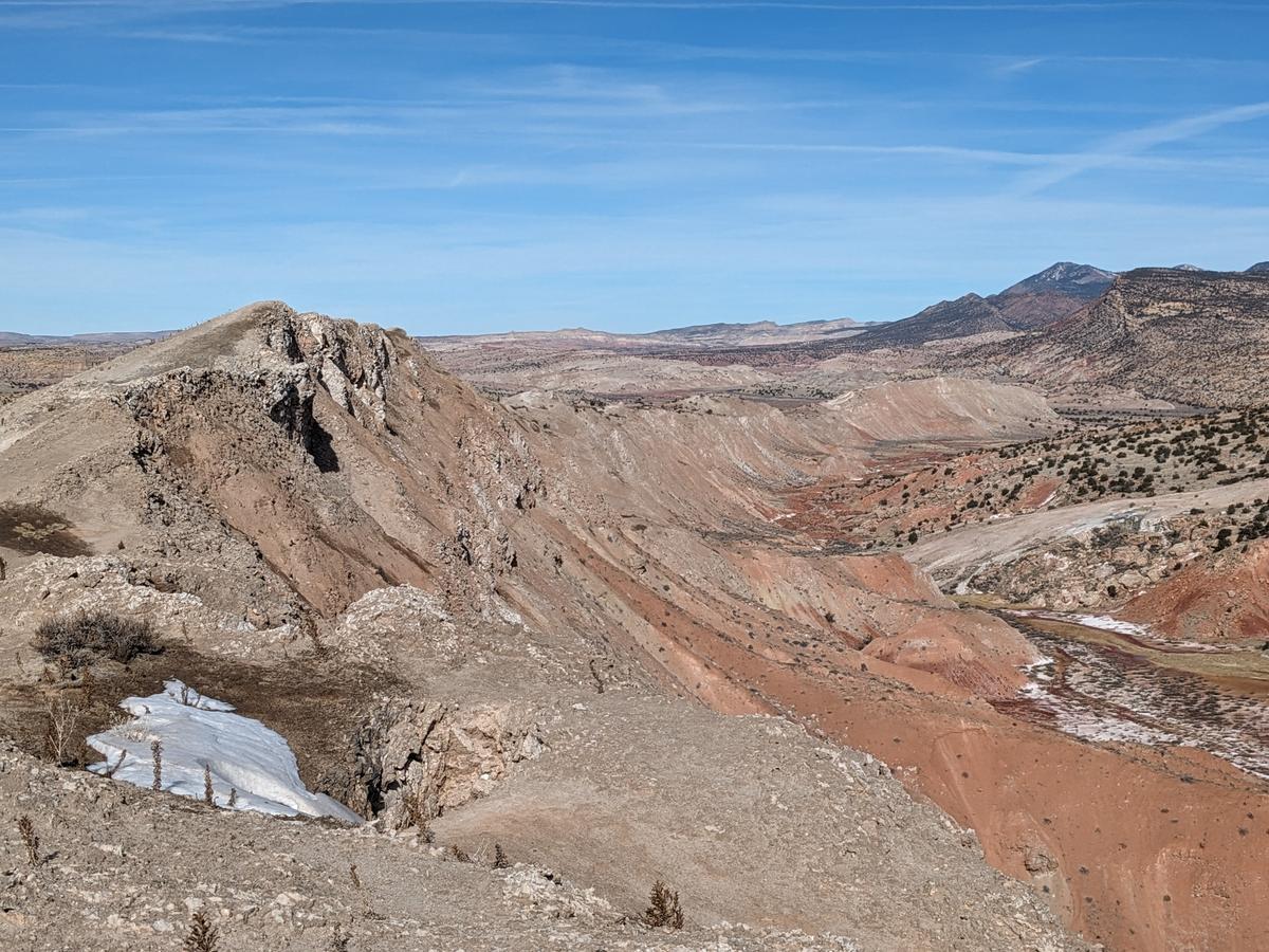
So we rode ... and rode. It was an easy trail with a few somewhat rocky sections (nothing nearly as bad as the "family friendly" rocky sections along the White Rock Canyon Rim). Before long we were a mile out, and we'd walked a few short sections but most of it had been easily rideable. And the views, as promised, were spectacular.
The ridge is supposedly made of gypsum, but it looked remarkably like marble,
and the view of the colorful red and green valley below, and White Mesa
on the other side of the valley, were terrific.
![[A valley filled with red hummocks and a green riparian zone]](https://shallowsky.com/blog/images/white-ridge-mtb/PXL_20240119_182828104.jpg) The redder rocks are apparently Morrison Formation, famous for dinosaurs:
in particular, Seismosaurus has been found in the adjacent Mojito Wilderness.
To the northwest, we could see Cabezon Peak, a local volcanic neck.
We decided to continue; worst case, if the riding did get too difficult,
we could always turn around and go back the way we'd come.
The redder rocks are apparently Morrison Formation, famous for dinosaurs:
in particular, Seismosaurus has been found in the adjacent Mojito Wilderness.
To the northwest, we could see Cabezon Peak, a local volcanic neck.
We decided to continue; worst case, if the riding did get too difficult,
we could always turn around and go back the way we'd come.
![[A biker walking a tricky downhill trail section]](https://shallowsky.com/blog/images/white-ridge-mtb/PXL_20240119_192307269.jpg) In the end, we didn't do the complete Dragon's Back.
Near the end, there's a section where the trail descends to a saddle,
and then you can see it climbing up and over a tall ridge.
This section is noted on the map as "Hike-a-Bike".
That didn't appeal to either of us, so we took the escape route
down to the green bunny trail, then took the bunny trail around the end
of the Hike-a-Bike mesa to where we could catch the return trail.
In the end, we didn't do the complete Dragon's Back.
Near the end, there's a section where the trail descends to a saddle,
and then you can see it climbing up and over a tall ridge.
This section is noted on the map as "Hike-a-Bike".
That didn't appeal to either of us, so we took the escape route
down to the green bunny trail, then took the bunny trail around the end
of the Hike-a-Bike mesa to where we could catch the return trail.
![[A valley of very red dirt, with a white-lined stream running through it]](https://shallowsky.com/blog/images/white-ridge-mtb/PXL_20240119_190241872.jpg)
Blue to Red
The blue trails in the northeast were nothing to worry about. I'm not sure where they transitioned to red; the difficulty didn't increase significantly. The trail winds through a colorful mineral spring -- "Little Yellowstone", I quipped. We did have to walk a few short sections, particularly where the trail went through patches of snow or mud.
![[a very deep hole/cave in layered rock]](https://shallowsky.com/blog/images/white-ridge-mtb/PXL_20240119_203740965.jpg) Remember how I said earlier that the rock looked like limestone or marble?
Up on the Dragon's Back, we'd seen lots of karst formations, holes in the
rock like miniature caves. But those were nothing compared to the caves
in the red trail (I wish these trails had names). We came upon one
impressive hole that had a drop of about six feet to a pool of water
(no telling how deep that water was). But some hikers we met told us
there was a much deeper cave farther on. Our explorations took us back
and forth and the hikers ended up making as good time as we did, so
when we got to the cave they showed us how to find it. It was maybe fifty
feet down to the pool of water, and again, no telling how much deeper it
went. There might be a balrog down there.
Remember how I said earlier that the rock looked like limestone or marble?
Up on the Dragon's Back, we'd seen lots of karst formations, holes in the
rock like miniature caves. But those were nothing compared to the caves
in the red trail (I wish these trails had names). We came upon one
impressive hole that had a drop of about six feet to a pool of water
(no telling how deep that water was). But some hikers we met told us
there was a much deeper cave farther on. Our explorations took us back
and forth and the hikers ended up making as good time as we did, so
when we got to the cave they showed us how to find it. It was maybe fifty
feet down to the pool of water, and again, no telling how much deeper it
went. There might be a balrog down there.
Anyway, the riding was all very pleasant and scenic. At one point a trail, marked black (Severe) goes off to the left, but despite having had little difficulty with the Dragon's Back, we decided to stick with the supposedly easier red trail. It took us up and down some little rises and eventually it dropped down into a big valley.
By this point we were getting a little nervous. We were down in the red and green valley we'd seen from the Dragon's Back, but to the south (the direction we needed to go to get back to the car), we could see tall cliffs looming, with no obvious way up. It seemed like we were riding into a box canyon. We could see our trail going down into the valley, but on the other side we couldn't see any corresponding trail up onto the mesa.
Boxed In
![[A trail leads up a very steep, muddy hill with scattered snow]](https://shallowsky.com/blog/images/white-ridge-mtb/PXL_20240119_215325527.jpg) We were right to be worried. The trail was obvious and easy to follow
across the valley floor — and then it basically disappeared.
You could see where one or two bikes had hone this way or that,
and a few tracks that weren't on the White Ridge map at all and
OsmAnd showed as dead-ends,
but nothing that was clearly the trail. Straight ahead, we
could see maybe one bike tire trail and some footprints going straight
up an impossibly steep cliff — and when I say impossibly, I mean
it, because it was muddy, and in the slick red mud we could barely even
walk on level ground without slipping. Mud was clinging to our tires to
the point where my bike wouldn't even roll due to all the mud caught
between the wheel, brakes and frame.
(I wish I'd taken a photo of that, but by that time I was more
worried about whether we were going to spend the night in the valley
than about picture-taking.)
We were right to be worried. The trail was obvious and easy to follow
across the valley floor — and then it basically disappeared.
You could see where one or two bikes had hone this way or that,
and a few tracks that weren't on the White Ridge map at all and
OsmAnd showed as dead-ends,
but nothing that was clearly the trail. Straight ahead, we
could see maybe one bike tire trail and some footprints going straight
up an impossibly steep cliff — and when I say impossibly, I mean
it, because it was muddy, and in the slick red mud we could barely even
walk on level ground without slipping. Mud was clinging to our tires to
the point where my bike wouldn't even roll due to all the mud caught
between the wheel, brakes and frame.
(I wish I'd taken a photo of that, but by that time I was more
worried about whether we were going to spend the night in the valley
than about picture-taking.)
We found a slightly less muddy place to stop and scoop out enough mud that the bikes could roll again, and continued south, but the trail just bumped up against a several hundred foot cliff. We tried three different ways of climbing the cliff, but none of them were doable pushing a bike. The OpenStreetMap trails OsmAnd was showing me showed. lots of abortive trails that went up into different box canyons and then ended without a way out; the only route it showed as a through trail was the one that went straight up the slippery muddy slope.
Lessons Learned ... Or Not
After maybe an hour and a half of trying to find a way out, we gave up.
It was 3pm and starting to get chilly,
and we decided our only safe route was to go all the way back to the north
end of the Dragon's Back, loop around and take the green bunny trail
back to the car. The black trail would be a lot shorter, but what if it
ended in an impossible section as well?
![[map of our ride]](https://shallowsky.com/blog/images/white-ridge-mtb/white-ridge-2024-01-19.jpg) It was a long slog and we were both feeling pretty wiped out by the
time we finally straggled back to the car just after sunset.
But at least we didn't get stuck in that valley, or up on the ridge,
overnight.
It was a long slog and we were both feeling pretty wiped out by the
time we finally straggled back to the car just after sunset.
But at least we didn't get stuck in that valley, or up on the ridge,
overnight.
I'm not sure what the lesson is here. The map clearly showed a trail that should have taken us back to the start, with no indication of a crux that might be impossible in some weather conditions. And it clearly implied that a red trail should be easier than the black trail we'd already ridden. I guess the real lesson is: when you're riding somewhere unfamiliar, never assume that any trail goes through, whatever the map might say, and always leave time to retrace your entire ride back to the beginning. Oh, and when riding anywhere unfamiliar, bring your lunch along — don't leave it in the car planning on eating it after you finish riding. I had a mini Kind bar in my pack, but sure could have used a bit more fuel.
I did quite enjoy the Dragon's Back part of the ride, and the mineral
springs and the two karst caves. There's some excellent riding, and
scenery, at White Ridge. And it was nice to get out on the mountain bike
in the middle of winter when our local trails are unrideable.
But the total of a bit over 15 miles and 6 hours was a bit beyond
what we thought we were signing up for.
[ 19:41 Jan 20, 2024 More bike | permalink to this entry | ]