Shallow Thoughts : tags : travel
Akkana's Musings on Open Source Computing and Technology, Science, and Nature.
Sat, 10 Jan 2026
![[Three Douglas fir trees growing together, just below a concrete balcony. The moon tree is the middle one.]](https://shallowsky.com/blog/images/travel/moontrees/PXL_20260106_220623718T.jpg) The Radiolab podcast (or actually, their "Terrestrials" spinoff for kids)
recently had an episode about
Moon Trees.
The Radiolab podcast (or actually, their "Terrestrials" spinoff for kids)
recently had an episode about
Moon Trees.
Stuart ‘Smokey’ Roosa
went to the moon (well, at least to lunar orbit) in 1971
as the Command Module Pilot for Apollo 14. He was an
ex-firefighter, ex-smoke jumper, and he loved trees.
So for the small personal item that astronauts are allowed to carry on
missions, he brought along a canister of 500 tree seeds of various types.
After almost getting destroyed (listen to the episode for more detail
on Stu and his seeds), the seeds ended up back on earth, where they were
planted in a variety of locations, from the White House lawn to
private yards.
And then ... everyone forgot about them for a while, until their
rediscovery by a third grader (again, listen to the episode, it's a
great story). More recently, Natalie Middleton wrote an
article about
Moon Trees, including a map of the currently known moon trees.
I checked the map to see if there were any in New Mexico. There's one
in Silver City, a sycamore, and some day I'll get down there to visit
— but wonder of wonders, there's also a Douglas fir Moon Tree in
Santa Fe! It's at the Roundhouse (the state capitol). I had to go see it.
Read more ...
Tags: astronomy, moon, travel, nature, moon trees
[
14:45 Jan 10, 2026
More travel |
permalink to this entry |
]
Tue, 22 Apr 2025
It was 2001, and
Dave and I were off on a road trip to see the Canadian Rockies.
My first time in another country! (Not counting an hour or two in Tijuana
as a kid, and a day trip to New Brunswick as a college student.)
Our plan was to drive up through Portland, then
follow the Columbia River through eastern Oregon, Washington and Idaho
— places I'd always wanted to see. We'd make our way into Canada,
up to Banff and Jasper, then make a loop coming back down through
Glacier. Beyond that we didn't have any specific plans.
Read more ...
Tags: travel, humor, geology
[
15:04 Apr 22, 2025
More travel |
permalink to this entry |
]
Fri, 09 Aug 2024
![[A sign on a platform in a field of weeds: COLORADO GATORS Discount Tickets sold HERE! with a picture of an alligator's head, and inside its open mouth is a smaller sign, Open Daily! ]](https://shallowsky.com/blog/images/trips/alamosa/PXL_20240807_214437944T.jpg) A recent trip through Alamosa reminded me that I'd never written about
my trip to see the gators. High time!
A recent trip through Alamosa reminded me that I'd never written about
my trip to see the gators. High time!
As you drive up Colorado highway 17 north of Alamosa, you pass a
series of old, faded, hand-painted signs saying things like
"Alligators? In Colorado?" and "COLORADO GATORS Discount Tickets sold HERE!"
I'd seen them for years, and chuckled a little but didn't ever give them much thought.
The desert is full of signs for roadside attractions that were
abandoned fifty years ago.
But five or six years ago, someone told me
that Colorado Gators actually was quite an interesting place, too bad it had
recently closed. Darnit — why couldn't someone have told me that
before it closed? Oh, well.
Then last year, we were heading up 17 on our way to visit the
relatives, and I couldn't help noticing that there were really quite
a lot of signs for an attraction that was supposedly gone.
And some of the signs looked fairly new. We had some time to spare, so we
took the detour and found Colorado Gators still very much open for business.
Read more ...
Tags: travel, nature, alligators, roadside attraction
[
11:04 Aug 09, 2024
More travel |
permalink to this entry |
]
Mon, 13 Nov 2023
![[Clayton Lake dinosaur tracks]](https://shallowsky.com/images/clayton-raton/PXL_20231109_212910341sm.jpg) We've been taking some little 2- and 3-day trips to explore parts of
New Mexico we haven't seen much. Last week, we visited Clayton and Raton,
in the northeast corner of the state.
We've been taking some little 2- and 3-day trips to explore parts of
New Mexico we haven't seen much. Last week, we visited Clayton and Raton,
in the northeast corner of the state.
We'd been through Wagon Mound and Raton before but hadn't stopped.
We'd never been to Clayton.
Our goals were to see the dinosaur tracks at Clayton Lake, to try to
find the Folsom site or the museum in Folsom, and to see what else
the area had to offer. You don't know 'til you go.
Read more ...
Tags: travel, geology, dinosaur
[
18:30 Nov 13, 2023
More travel |
permalink to this entry |
]
Thu, 11 Jun 2020
![[Rainbow over Shumo from Overlook Park]](http://shallowsky.com/images/overlook/20160914_185703T.jpg) "Ho hum, it's just our local city park", we say, walking back
to the parking area from the overlook at Overlook Park here in White Rock.
"Ho hum, it's just our local city park", we say, walking back
to the parking area from the overlook at Overlook Park here in White Rock.
We're joking, of course. The Overlook has stunning views of White Rock
Canyon that change as the light changes. It's maybe three miles from
home, and we visit it fairly often and never get tired of the view.
It's amazing to have a place like this so close to home.
And sometimes we get to thinking: how many other towns have a
city park that compares?
Read more ...
Tags: travel, nature
[
14:55 Jun 11, 2020
More travel |
permalink to this entry |
]
Thu, 05 Apr 2018
A week ago I got back from a trip to the Chiricahua mountains of
southern Arizona, specifically Cave Creek on the eastern side of the range.
The trip was theoretically a hiking trip, but it was also for birding
and wildlife watching -- southern Arizona is near the Mexican border
and gets a lot of birds and other animals not seen in the rest of the
US -- and an excuse to visit a friend who lives near there.
Although it's close enough that it could be driven in one fairly long
day, we took a roundabout 2-day route so we could explore some other
areas along the way that we'd been curious about.
First, we wanted to take a look at the White Mesa Bike Trails
northwest of Albuquerque, near the Ojito Wilderness. We'll be back at
some point with bikes, but we wanted to get a general idea of the
country and terrain. The Ojito, too, looks like it might be worth
a hiking trip, though it's rather poorly signed: we saw several kiosks
with maps where the "YOU ARE HERE" was clearly completely misplaced.
Still, how can you not want to go back to a place where the two main
trails are named Seismosaurus and Hoodoo?
![[Cabezon]](http://shallowsky.com/images/cavecreek/gettingthere/img_8756T.jpg) The route past the Ojito also led past Cabezon Peak, a volcanic neck
we've seen from a long distance away and wanted to see closer. It's
apparently possible to climb it but we're told the top part is fairly
technical, more than just a hike.
The route past the Ojito also led past Cabezon Peak, a volcanic neck
we've seen from a long distance away and wanted to see closer. It's
apparently possible to climb it but we're told the top part is fairly
technical, more than just a hike.
Finally, we went up and over Mt Taylor, something we've been meaning
to do for many years. You can drive fairly close to the top, but
this being late spring, there was still snow on the upper part of
the road and our Rav4's tires weren't up to the challenge. We'll
go back some time and hike all the way to the top.
We spent the night in Grants, then the following day, headed down
through El Malpais, stopping briefly at the beautiful Sandstone Overlook,
then down through the Datil and Mogollon area. We wanted to take a
look at a trail called the Catwalk, but when we got there, it was
cold, blustery, and starting to rain and sleet. So we didn't hike the
Catwalk this time, but at least we got a look at the beginning of it,
then continued down through Silver City and thence to I-10,
where just short of the Arizona border we were amused by the
Burma
Shave dust storm signs about which I already wrote.
At Cave Creek
![[Beautiful rocks at Cave Creek]](http://shallowsky.com/images/cavecreek/cavecreek/img_8807T.jpg) Cave Creek Ranch, in Portal, AZ,
turned out to be a lovely place to stay, especially
for anyone interested in wildlife. I saw several "life birds" and
mammals, plus quite a few more that I'd seen at some point but had
never had the opportunity to photograph. Even had we not been hiking,
just hanging around the ranch watching the critters was a lot of fun.
They charge $5 for people who aren't staying there to come and sit in
the feeder area; I'm not sure how strictly they enforce it, but given
how much they must spend on feed, it would be nice to help support them.
Cave Creek Ranch, in Portal, AZ,
turned out to be a lovely place to stay, especially
for anyone interested in wildlife. I saw several "life birds" and
mammals, plus quite a few more that I'd seen at some point but had
never had the opportunity to photograph. Even had we not been hiking,
just hanging around the ranch watching the critters was a lot of fun.
They charge $5 for people who aren't staying there to come and sit in
the feeder area; I'm not sure how strictly they enforce it, but given
how much they must spend on feed, it would be nice to help support them.
The bird everyone was looking for was the Elegant Trogon. Supposedly
one had been seen recently along the creekbed, and we all wanted to
see it.
They also had a nifty suspension bridge for pedestrians crossing a dry
(this year) arroyo over on another part of the property. I guess I was
so busy watching the critters that I never went wandering around, and
I would have missed the bridge entirely had Dave not pointed it out
to me on the last day.
The only big hike I did was the Burro Trail to Horseshoe Pass, about
10 miles and maybe 1800 feet of climbing. It started with a long hike
up the creek, during which everybody had eyes and ears trained on the
sycamores (we were told the trogon favored sycamores). No trogon.
But it was a pretty hike, and once we finally started climbing out of
the creekbed there were great views of the soaring cliffs above Cave
Creek Canyon. Dave opted to skip the upper part of the trail to the
saddle; I went, but have to admit that it was mostly just more of the
same, with a lot of scrambling and a few difficult and exposed traverses.
At the time I thought it was worth it, but by the time we'd slogged
all the way back to the cars I was doubting that.
![[ Organ Pipe Formation at Chiricahua National Monument ]](http://shallowsky.com/images/cavecreek/chiricahua/img_8932T.jpg) On the second day the group went over the Chiricahuas to Chiricahua
National Monument, on the other side. Forest road 42 is closed in
winter, but we'd been told that it was open now since the winter had
been such a dry one, and it wasn't a particularly technical road,
certainly easy in the Rav4. But we had plans to visit our friend over
at the base of the next mountain range west, so we just made a quick
visit to the monument, did a quick hike around the nature trail and
headed on.
On the second day the group went over the Chiricahuas to Chiricahua
National Monument, on the other side. Forest road 42 is closed in
winter, but we'd been told that it was open now since the winter had
been such a dry one, and it wasn't a particularly technical road,
certainly easy in the Rav4. But we had plans to visit our friend over
at the base of the next mountain range west, so we just made a quick
visit to the monument, did a quick hike around the nature trail and
headed on.
Back with the group at Cave Creek on Thursday, we opted for a shorter,
more relaxed hike in the canyon to Ash Spring rather than the brutal
ascent to Silver Peak. In the canyon, maybe we'd see the trogon!
Nope, no trogon. But it was a very pleasant hike, with our first
horned lizard ("horny toad") spotting of the year, a couple of other
lizards, and some lovely views.
Critters
We'd been making a lot of trogon jokes over the past few days, as we
saw visitor after visitor trudging away muttering about not having
seen one. "They should rename the town of Portal to Trogon, AZ." "They
should rename that B&B Trogon's Roost Bed and Breakfast." Finally,
at the end of Thursday's hike, we stopped in at the local ranger
station, where among other things (like admiring their caged gila
monster) we asked about trogon sightings. Turns out the last one to be
seen had been in November. A local thought maybe she'd heard one in
January. Whoever had relayed the rumor that one had been seen recently
was being wildly optimistic.
![[ Northern Cardinal ]](http://shallowsky.com/images/cavecreek/birds/img_2165T.jpg)
![[ Coati ]](http://shallowsky.com/images/cavecreek/mammals/img_2109T.jpg)
![[ Javalina ]](http://shallowsky.com/images/cavecreek/mammals/img_2242T.jpg)
![[ white-tailed buck ]](http://shallowsky.com/images/cavecreek/mammals/img_2189T.jpg)
Fortunately, I'm not a die-hard birder and I didn't go there
specifically for the trogon. I saw lots of good birds and some mammals
I'd never seen before
(full
list), like a coatimundi (I didn't realize those ever came up to
the US) and a herd (pack? flock?) of javalinas. And white-tailed deer
-- easterners will laugh, but those aren't common anywhere I've lived
(mule deer are the rule in California and Northern New Mexico). Plus
some good hikes with great views, and a nice visit with our friend. It
was a good trip.
On the way home, again we took two days for the opportunity to visit
some places we hadn't seen. First, Cloudcroft, NM: a place we'd heard
a lot about because a lot of astronomers retire there. It's high in
the mountains and quite lovely, with lots of hiking trails in the
surrounding national forest. Worth a visit some time.
From Cloudcroft we traveled through the Mescalero Apache reservation,
which was unexpectedly beautiful, mountainous and wooded and dotted
with nicely kept houses and ranches, to Ruidoso, a nice little town
where we spent the night.
Lincoln
![[ Lincoln, NM ]](http://shallowsky.com/images/cavecreek/triphome/img_9026T.jpg) Our last stop, Saturday morning, was Lincoln, site of the Lincoln
County War (think Billy the Kid). The whole tiny town is set up as a
tourist attraction, with old historic buildings ... that were all
closed. Because why would any tourists be about on a beautiful
Saturday in spring? There were two tiny museums, one at each end of
town, which were open, and one of them tried to entice us into paying
the entrance fee by assuring us that the ticket was good for all the
sites in town. Might have worked, if we hadn't already walked the
length of the town peering into windows of all the closed sites. Too
bad -- some of them looked interesting, particularly the general store.
But we enjoyed our stroll through the town, and we got a giggle out of
the tourist town being closed on Saturday -- their approach to tourism
seems about as effective as Los Alamos'.
Our last stop, Saturday morning, was Lincoln, site of the Lincoln
County War (think Billy the Kid). The whole tiny town is set up as a
tourist attraction, with old historic buildings ... that were all
closed. Because why would any tourists be about on a beautiful
Saturday in spring? There were two tiny museums, one at each end of
town, which were open, and one of them tried to entice us into paying
the entrance fee by assuring us that the ticket was good for all the
sites in town. Might have worked, if we hadn't already walked the
length of the town peering into windows of all the closed sites. Too
bad -- some of them looked interesting, particularly the general store.
But we enjoyed our stroll through the town, and we got a giggle out of
the tourist town being closed on Saturday -- their approach to tourism
seems about as effective as Los Alamos'.
Photos from the trip are at
Cave Creek and the Chiricahuas.
Tags: travel, birds, hiking
[
10:04 Apr 05, 2018
More travel |
permalink to this entry |
]
Mon, 26 Mar 2018
I just got back from a trip to the Chiricahuas, specifically Cave Creek.
More on that later, after I've done some more photo triaging.
But first, a story from the road.
![[NM Burma Shave dust storm signs]](http://shallowsky.com/images/cavecreek/gettingthere/img_8785.jpg)
Driving on I-10 in New Mexico near the Arizona border, we saw several
signs about dust storms. The first one said,
ZERO VISIBILITY IS POSSIBLE
Dave commented, "I prefer the ones that say, 'may exist'."
And as if the highway department heard him, a minute or two later
we passed a much more typical New Mexico road sign:
DUST STORMS MAY EXIST
New Mexico, the existential state.
But then things got more fun. We drove for a few more miles, then we
passed a sign that obviously wasn't meant to stand alone:
IN A DUST STORM
"It's a Burma Shave!" we said simultaneously. (I'm not old
enough to remember Burma Shave signs in real life, but I've heard
stories and love the concept.) The next sign came quickly:
PULL OFF ROADWAY
"What on earth are they going to find to rhyme with 'roadway'?"
I wondered. I racked my brains but couldn't come up with anything.
As it turns out, neither could NMDOT. There were three more signs:
TURN VEHICLE OFF
FEET OFF BRAKES
STAY BUCKLED
"Hmph", I thought. "What an opportunity missed." But I still couldn't
come up with a rhyme for "roadway". Since we were on Interstate 10,
and there's not much to do on a long freeway drive, I penned an
alternative:
IN A DUST STORM
PULL OFF TEN
YOU WILL LIVE
TO DRIVE AGAIN
Much better, isn't it? But one thing bothered me: you're not really
supposed to pull all the way off Interstate 10, just onto the shoulder.
How about:
IN A DUST STORM
PULL TO SHOULDER
YOU WILL LIVE
TO GET MUCH OLDER
I wasn't quite happy with it. I thought my next attempt was an improvement:
IN A DUST STORM
PULL TO SHOULDER
YOU MAY CRASH IF
YOU ARE BOLDER
but Dave said I should stick with "GET MUCH OLDER".
Oh, well. Even if I'm not old enough to remember real Burma Shave signs,
and even if NMDOT doesn't have the vision to make their own signs rhyme,
I can still have fun with the idea.
Tags: humor, travel, sign, cavecreek, poetry
[
16:05 Mar 26, 2018
More travel |
permalink to this entry |
]
Thu, 20 Apr 2017
![[House on Fire ruin, Mule Canyon UT]](http://shallowsky.com/images/bluff2017/mulecyn/img_7409.jpg) Last week, my hiking group had its annual trip, which this year
was Bluff, Utah, near Comb Ridge and Cedar Mesa, an area particular
known for its Anasazi ruins and petroglyphs.
Last week, my hiking group had its annual trip, which this year
was Bluff, Utah, near Comb Ridge and Cedar Mesa, an area particular
known for its Anasazi ruins and petroglyphs.
(I'm aware that "Anasazi" is considered a politically incorrect term
these days, though it still seems to be in common use in Utah; it isn't
in New Mexico. My view is that I can understand why Pueblo people
dislike hearing their ancestors referred to by a term that means
something like "ancient enemies" in Navajo; but if they want everyone
to switch from using a mellifluous and easy to pronounce word like
"Anasazi", they ought to come up with a better, and shorter,
replacement than "Ancestral Puebloans." I mean, really.)
The photo at right is probably the most photogenic of the ruins I saw.
It's in Mule Canyon, on Cedar Mesa, and it's called "House on Fire"
because of the colors in the rock when the light is right.
The light was not right when we encountered it, in late morning around
10 am; but fortunately, we were doing an out-and-back hike. Someone in
our group had said that the best light came when sunlight reflected
off the red rock below the ruin up onto the rock above it, an effect
I've seen in other places, most notably Bryce Canyon, where the hoodoos
look positively radiant when seen backlit, because that's when
the most reflected light adds to the reds and oranges in the rock.
Sure enough, when we got back to House on Fire at 1:30 pm, the
light was much better. It wasn't completely obvious to the eye,
but comparing the photos afterward, the difference is impressive:
Changing
light on House on Fire Ruin.
![[Brain main? petroglyph at Sand Island]](http://shallowsky.com/images/bluff2017/butlerwash/img_7301.jpg) The weather was almost perfect for our trip, except for one overly hot
afternoon on Wednesday.
And the hikes were fairly perfect, too -- fantastic ruins you can see
up close, huge petroglyph panels with hundreds of different creatures
and patterns (and some that could only have been science fiction,
like brain-man at left), sweeping views of canyons and slickrock,
and the geology of Comb Ridge and the Monument Upwarp.
The weather was almost perfect for our trip, except for one overly hot
afternoon on Wednesday.
And the hikes were fairly perfect, too -- fantastic ruins you can see
up close, huge petroglyph panels with hundreds of different creatures
and patterns (and some that could only have been science fiction,
like brain-man at left), sweeping views of canyons and slickrock,
and the geology of Comb Ridge and the Monument Upwarp.
And in case you read my last article, on translucent windows, and are
wondering how those generated waypoints worked: they were terrific,
and in some cases made the difference between finding a ruin and
wandering lost on the slickrock. I wish I'd had that years ago.
Most of what I have to say about the trip are already in the comments to
the photos, so I'll just link to the photo page:
Photos: Bluff trip, 2017.
Tags: travel, photography
[
19:28 Apr 20, 2017
More travel |
permalink to this entry |
]
Sun, 03 Jul 2016
A few unusual nature observations noticed over the last few weeks ...
First, on a trip to Washington DC a week ago (my first time there).
For me, the big highlight of the trip was my first view of fireflies
-- bright green ones, lighting once or twice then flying away,
congregating over every park, lawn or patch of damp grass.
What fun!
Predatory grackle
![[grackle]](http://shallowsky.com/Birds/Perching_Birds/great_tailed_grackle.jpg)
But the unusual observation was around mid-day, on the lawn near the
Lincoln Memorial.
A grackle caught my attention as it flashed by me -- a male common
grackle, I think (at least, it was glossy black, relatively small and
with only a moderately long tail).
It turned out it was chasing a sparrow, which was dodging and trying
to evade, but unsuccessfully. The grackle made contact, and the sparrow
faltered, started to flutter to the ground. But the sparrow recovered and
took off in another direction, the grackle still hot on its tail. The
grackle made contact again, and again the sparrow recovered and kept
flying. But the third hit was harder than the other two, and the
sparrow went down maybe fifteen or twenty feet away from me, with the
grackle on top of it.
The grackle mantled over its prey like a hawk and looked like it was
ready to begin eating. I still couldn't quite believe what I'd seen, so I
stepped out toward the spot, figuring I'd scare the grackle away and
I'd see if the sparrow was really dead. But the grackle had its eye on
me, and before I'd taken three steps, it picked up the sparrow in its
bill and flew off with it.
I never knew grackles were predatory, much less capable of killing
other birds on the wing and flying off with them. But a web search
on grackles killing birds got quite a few hits about grackles
killing and eating house sparrows, so apparently it's not uncommon.
Daytime swarm of nighthawks
Then, on a road trip to visit friends in Colorado, we had to drive
carefully past the eastern slope of San Antonio Mountain as a flock of
birds wheeled and dove across the road. From a distance it looked like
a flock of swallows, but as we got closer we realized they were far
larger. They turned out to be nighthawks -- at least fifty of them,
probably considerably more. I've heard of flocks of nighthawks
swarming around the bugs attracted to parking lot streetlights. And
I've seen a single nighthawk, or occasionally two, hawking in the
evenings from my window at home. But I've never seen a flock of
nighthawks during the day like this. An amazing sight as they swoop
past, just feet from the car's windshield.
Flying ants
![[Flying ant courtesy of Jen Macke]](http://peecnature.org/wp-content/uploads/2016/06/IMG_7673-single-harvester.jpg)
Finally, the flying ants. The stuff of a bad science fiction movie!
Well, maybe if the ants were 100 times larger. For now, just an
interesting view of the natural world.
Just a few days ago,
Jennifer Macke wrote a
fascinating article in the PEEC Blog, "Ants Take Wing!" letting
everyone know that this is the time of year for ants to grow wings
and fly. (Jen also showed me some winged lawn ants in the PEEC ant
colony when I was there the day before the article came out.)
Both males and females grow wings; they mate in the air, and then
the newly impregnated females fly off, find a location, shed their
wings (leaving a wing scar you can see if you have a strong enough
magnifying glass) and become the queen of a new ant colony.
And yesterday morning, as Dave and I looked out the window, we saw
something swarming right below the garden. I grabbed a magnifying lens
and rushed out to take a look at the ones emerging from the ground,
and sure enough, they were ants. I saw only black ants. Our native
harvester ants -- which I know to be common in our yard, since I've
seen the telltale anthills surrounded by a large bare area where they
clear out all vegetation -- have sexes of different colors (at least
when they're flying): females are red, males are black. These flying
ants were about the size of harvester ants but all the ants I saw were
black. I retreated to the house and watched the flights with binoculars,
hoping to see mating, but all the flyers I saw seemed intent on dispersing.
Either these were not harvester ants, or the females come out at a
different time from the males. Alas, we had an appointment and had to
leave so I wasn't able to monitor them to check for red ants. But in a
few days I'll be watching for ants that have lost their wings ... and
if I find any, I'll try to identify queens.
Tags: nature, travel, birds, insects
[
09:28 Jul 03, 2016
More nature |
permalink to this entry |
]
Fri, 29 Apr 2016
![[Red Toadstool, in the Paria Rimrocks]](http://shallowsky.com/images/vermillion_cliffs/3_nautilus_toadstools_horseshoe/img_5296T.jpg)
![[Cobra Arch, in the Vermillion Cliffs]](http://shallowsky.com/images/vermillion_cliffs/4_cobra_arch/img_5402T.jpg) I haven't posted in a while. Partly I was busy preparing for, enjoying,
then recovering from, a hiking trip to the Vermillion Cliffs,
on the Colorado River near the Arizona/Utah border.
We had no internet access there (no wi-fi at the hotel, and no data
on the cellphone). But we had some great hikes, and I saw my first
California Condors (they have a site where they release captive-bred
birds).
Photos (from the hikes, not the condors, which were too far away):
Vermillion
Cliffs trip.
I haven't posted in a while. Partly I was busy preparing for, enjoying,
then recovering from, a hiking trip to the Vermillion Cliffs,
on the Colorado River near the Arizona/Utah border.
We had no internet access there (no wi-fi at the hotel, and no data
on the cellphone). But we had some great hikes, and I saw my first
California Condors (they have a site where they release captive-bred
birds).
Photos (from the hikes, not the condors, which were too far away):
Vermillion
Cliffs trip.
I've also been having fun welding more critters, including a
roadrunner, a puppy and a rattlesnake.
I'm learning how to weld small items,
like nail legs on spark plug dragonflies and scorpions, which tend
to melt at the MIG welder's lowest setting.

![[ Welded Roadrunner ]](http://shallowsky.com/metal/img_9967T.jpg)
![[ Welded rattlesnake ]](http://shallowsky.com/metal/img_0027T.jpg)
New Mexico's weather is being charmingly erratic (which is fairly usual):
we went for a hike exploring some unmapped cavate ruins, shivering in
the cold wind and occasionally getting lightly snowed upon. Then the
next day was a gloriously sunny hike out Deer Trap Mesa with clear
long-distance views of the mountains and mesas in all directions.
Today we had
graupel
-- someone recently introduced me to that term for what Dave
and I have been calling "snail" or "how" since it's a combination of
snow and hail, soft balls of hail like tiny snowballs. They turned the
back yard white for ten or fifteen minutes, but then the sun came out
for a bit and melted all the little snowballs.
But since it looks like much of today will be cloudy, it's a perfect
day to use up that leftover pork roast and fill the house with good
smells by making a batch of slow-cooker green chile posole.
Tags: travel, hiking
[
12:28 Apr 29, 2016
More travel |
permalink to this entry |
]
Sun, 15 Dec 2013
On way home from a trip last week, one of the hotels we stayed at had
an unexpected bonus:
Hi-Fi Internet!
![[Hi-fi internet]](http://shallowsky.com/blog/images/humor/img_8823-hifi.jpg)
You may wonder, was it mono or stereo?
They had two accesspoints visible (with different essids), so I guess
it was supposed to be stereo. Except one of the accesspoints never worked,
so it turned out to be mono after all.
Tags: humor, travel, tech
[
19:35 Dec 15, 2013
More humor |
permalink to this entry |
]
Wed, 02 Oct 2013
On a trip last month, Mesquite, NV gave us couple of avian delights.
First the roadrunner,
strutting around a side street poking its head into bushes, hunting
as we watched from the car.
![[Huge flock of grackles]](http://shallowsky.com/blog/images/trips/4corners2013/img_8041.jpg) Then, in the evening, a convocation of grackles -- several hundred of
them -- in the tree just across from the third-floor balcony at our
casino hotel.
All chattering with each other, making an amazing variety of noises
as they flew from branch to branch, occasionally bickering or feeding
each other or landing on a branch too weak to support them.
Then, in the evening, a convocation of grackles -- several hundred of
them -- in the tree just across from the third-floor balcony at our
casino hotel.
All chattering with each other, making an amazing variety of noises
as they flew from branch to branch, occasionally bickering or feeding
each other or landing on a branch too weak to support them.
Grackles make some amazing sounds. We don't have them at home, so I
only hear them on trips, but they always want to make me look for the
amplifier and speakers -- it seems impossible that a medium-sized bird
could be making all that sound, and such a variety of noise, all by itself.
We stood there for maybe 20 minutes, watching them and listening,
shooting photos and video,
before the heat (over 100 even after sunset) got to us and we had
to go back into the room.
![[Don't park under a grackle tree]](http://shallowsky.com/blog/images/trips/4corners2013/img_8052.jpg) Unfortunately, in all that time, one thing that never occurred to us was
that our car was parked right under that tree. We realized that the
next morning.
Unfortunately, in all that time, one thing that never occurred to us was
that our car was parked right under that tree. We realized that the
next morning.
And we had thought we were so clever, finding the one shady spot in
that parking lot!
Tags: nature, birds, travel
[
14:38 Oct 02, 2013
More travel |
permalink to this entry |
]
Mon, 02 Sep 2013
We recently returned from a quick whirlwind trip through a series
of towns in the Four Corners area: the place where Arizona, New
Mexico, Colorado and Utah come together.
![[Hot-air balloon landing in the road in Cortez, CO]](http://shallowsky.com/blog/images/trips/4corners2013/img_7968.jpg) One highlight:
watching hot-air balloons floating across the sky against the backdrop
of Mesa Verde in Cortez, CO ... and watching one accidentally
land in the middle of the highway in front of our motel
(the White Eagle Inn, a charming little place with super nice owners).
One highlight:
watching hot-air balloons floating across the sky against the backdrop
of Mesa Verde in Cortez, CO ... and watching one accidentally
land in the middle of the highway in front of our motel
(the White Eagle Inn, a charming little place with super nice owners).
Cars stopped on the highway while someone jumped out of the basket and
pushed the balloon toward the side of the road. The truck on the left
is the chase crew.
(And yes, that's a powerline in the foreground, very close to where
the balloon came down.)
![[Hot-air balloons in Cortez, CO]](http://shallowsky.com/blog/images/trips/4corners2013/img_7973.jpg) The sky was full of balloons, and the hotel was as good a place as any
to watch them. Quite a way to start the morning!
The sky was full of balloons, and the hotel was as good a place as any
to watch them. Quite a way to start the morning!
Other highlights:
The view of the Rio Grande from the White Rock Overlook with lightning
flashing in the background.
![[Rio Grande panorama from White Rock, NM Overlook Park]](http://shallowsky.com/blog/images/trips/4corners2013/whiterockpano700.jpg) (No lightning in the photo, just a 13-image panorama. Click for a
bigger version.)
(No lightning in the photo, just a 13-image panorama. Click for a
bigger version.)
Dinner at Rancho de Chimayo. I had their famous carne adovada,
Dave had a stuffed sopaipilla with green chile, and we shared.
And sopaipillas with honey on the side, of course.
They're just as good as they were the first time I was there ...
was that really a quarter century ago?
All the motels that are using WPA passwords for their wi-fi, instead
of stupid browser pages that you have to re-authenticate every time
the connection drops. Things are looking up, gradually, for motel wi-fi.
![[The working Ivanpah solar collector]](http://shallowsky.com/blog/images/trips/4corners2013/img_8062.jpg) Heading back into California,
driving past Primm, NV, we checked out the progress on the new solar tower
collector being built at old Ivanpah. It's changed a lot since we were
there last. It looks like one tower is operational (though its mirror
array doesn't appear to extend all the way around yet), while two more
towers have mirror arrays but still have covers over the central tower.
Heading back into California,
driving past Primm, NV, we checked out the progress on the new solar tower
collector being built at old Ivanpah. It's changed a lot since we were
there last. It looks like one tower is operational (though its mirror
array doesn't appear to extend all the way around yet), while two more
towers have mirror arrays but still have covers over the central tower.
![[All three Ivanpah solar collectors]](http://shallowsky.com/blog/images/trips/4corners2013/img_8075.jpg)
Tags: travel, desert
[
21:15 Sep 02, 2013
More travel |
permalink to this entry |
]
Sat, 07 Jul 2012
On a brief and visit to San Luis Obispo, an unexpected bonus
was the unusual wildlife about town.
We walked from our hotel on Monterey St. to downtown to stretch our
legs, explore the mission and river walk and then get dinner.
(Mo's Smokehouse has excellent barbecue.)
On the way back, I noticed a small figure in the gutter just below
the curb, scratching and nosing around in the litter there.
It was the size and shape of a chipmunk, but its coloration showed
it to be a California ground squirrel -- a baby, probably on one of
its first forays out of the burrow.
Burrow? Well, as I pulled my camera out of a pocket, suddenly the
youngster vanished. I stepped into the street to see where it had
gone -- and discovered that SLO has gutter drain holes in their concrete
curbs that are exactly the size and shape of a typical ground
squirrel's burrow entryway.
![[Grossly fat California ground squirrel at Morro Rock]](http://shallowsky.com/nature/squirrels/jabba-the-sqrl.jpg) The size of these tiny ground squirrels was especially amazing because
just a few miles northwest, at Morro Rock, we'd encountered the most
humungous, gihugicle California ground squirrels known to man -- animals
so swollen from tourist handouts that at first I took them for prairie dogs.
(I wasn't able to photograph the tiny and quick SLO squirrels, but
the sluggish Morro Rock squirrels were a much easier target ... as you see.)
The size of these tiny ground squirrels was especially amazing because
just a few miles northwest, at Morro Rock, we'd encountered the most
humungous, gihugicle California ground squirrels known to man -- animals
so swollen from tourist handouts that at first I took them for prairie dogs.
(I wasn't able to photograph the tiny and quick SLO squirrels, but
the sluggish Morro Rock squirrels were a much easier target ... as you see.)
Back in SLO, we walked on, marvelling at the little squirrel -- and
half a block later, another squirreling
the same size as the other one dashed out from under a car, ran to the
curb and disappeared. Yep -- another of those round gutter holes.
They must have a whole colony of these cuties!
Then just a few blocks later, I noticed motion out of the corner of my eye
... and turned in time to watch a pair of scarlet macaws fly across
the street, up an adjacent street and into a tree.
I read an article once from a biologist who visited South America and
thrilled to the sight of these huge, bright red, long-tailed parrots
flying free ... but I never expected to see the same thing on the
street of a California city.
Tags: nature, travel
[
13:42 Jul 07, 2012
More nature |
permalink to this entry |
]
Tue, 22 May 2012
![[Annular eclipse 2012]](http://shallowsky.com/images/annular-eclipse-2012/img_5308T.jpg) I've just seen the annular eclipse, and what a lovely sight it was!
I've just seen the annular eclipse, and what a lovely sight it was!
This was only my second significant solar eclipse, the first being a
partial when I was a teenager. So I was pretty excited about an
annular so nearby -- the centerline was only about a 4-hour drive from home.
We'd made arrangements to join the Shasta astronomy club's eclipse party
at Whiskeytown Lake, up in the Trinity Alps. Sounded like a lovely spot,
and we'd be able to trade views with the members of the local astronomy
club as well as showing off the eclipse to the public. As astronomers
bringing telescopes, we'd get reserved parking and didn't even have to
pay the park fee. Sounded good!
Not knowing whether we might hit traffic, we left home first thing in
the morning, hours earlier than we figured was really necessary.
A good thing, as it turned out.
Not because we hit any traffic -- but because when we got to the site,
it was a zoo. There were cars idling everywhere, milling up and
down every road looking for parking spots.
We waited in the queue at the formal site, and finally got to the
front of the line, where we told the ranger we were bringing
telescopes for the event. He said well, um, we could drive in and
unload, but there was no parking so we'd just have to drive out
after unloading, hope to find a parking spot on the road somewhere,
and walk back.
What a fiasco!
After taking a long look at the constant stream of cars inching along in
both directions and the chaotic crowd at the site, we decided the
better part of valor was to leave this vale of tears and high-tail it
back to our motel in Red Bluff, only little farther south of the
centerline and still well within the path of annularity. Fortunately
we'd left plenty of extra time, so we made it back with time to spare.
The Annular Eclipse itself
![[early stage of annular eclipse 2012, showing sunspots]](http://shallowsky.com/images/annular-eclipse-2012/img_5402T.jpg) One striking thing about watching the eclipse through a telescope was
how fast the moon moves. The sun was well decorated with several excellent
large sunspot groups, so we were able to watch the moon swallow them
bit by bit.
One striking thing about watching the eclipse through a telescope was
how fast the moon moves. The sun was well decorated with several excellent
large sunspot groups, so we were able to watch the moon swallow them
bit by bit.
Some of the darker sunspot umbras even showed something like a
black drop effect
as they disappeared behind the moon. We couldn't see the same
effect on the smaller sunspot groups, or on the penumbras.
![[black drop at end of annularity]](http://shallowsky.com/images/annular-eclipse-2012/img_5412T.jpg) There was also a pronounced black drop effect at the onset and end
of annularity.
There was also a pronounced black drop effect at the onset and end
of annularity.
The seeing was surprisingly good, as solar observing goes. Not only
could we see good detail on the sunspot groups and solar faculae,
but we could easily see irregularities in the shape of the moon's
surface -- in particular one small sharp mountain peak on the leading edge,
and what looked like a raised crater wall farther south on that
leading edge. We never did get a satisfactory identification on
either feature.
![[pinhole eclipse viewing]](http://shallowsky.com/images/annular-eclipse-2012/img_5287T.jpg) After writing and speaking about eclipse viewing, I felt honor bound
to try viewing with pinholes of several sizes. I found that during early
stages of the eclipse, the pinholes had to be both small (under about
5 mm) and fairly round to show much. Later in the eclipse,
nearly anything worked to show the crescent or the annular ring,
including interlaced fingers or the shadow of a pine tree on the wall.
I wish I'd remembered to take an actual hole punch, which would have
been just about perfect.
After writing and speaking about eclipse viewing, I felt honor bound
to try viewing with pinholes of several sizes. I found that during early
stages of the eclipse, the pinholes had to be both small (under about
5 mm) and fairly round to show much. Later in the eclipse,
nearly anything worked to show the crescent or the annular ring,
including interlaced fingers or the shadow of a pine tree on the wall.
I wish I'd remembered to take an actual hole punch, which would have
been just about perfect.
![[binocular projection for eclipse]](http://shallowsky.com/images/annular-eclipse-2012//img_5283T.jpg) I also tried projection through binoculars, and convinced myself that
it would probably work as a means of viewing next month's Venus
transit -- but only with the binoculars on a tripod. Hand-holding
them is fiddly and difficult. (Of course, never look through
binoculars at the sun without a solar filter.) Look for an upcoming
article with more details on binocular projection.
I also tried projection through binoculars, and convinced myself that
it would probably work as a means of viewing next month's Venus
transit -- but only with the binoculars on a tripod. Hand-holding
them is fiddly and difficult. (Of course, never look through
binoculars at the sun without a solar filter.) Look for an upcoming
article with more details on binocular projection.
The cast of characters
 For us, the motel parking lot worked out great. We were staying at the
Crystal Motel in Red Bluff, an unassuming little motel that proved to be
clean and quiet, with friendly, helpful staff and the fastest motel
wi-fi connection I've ever seen. Maybe not the most scenic of
locations, but that was balanced by the convenience of having the car
and room so close by.
For us, the motel parking lot worked out great. We were staying at the
Crystal Motel in Red Bluff, an unassuming little motel that proved to be
clean and quiet, with friendly, helpful staff and the fastest motel
wi-fi connection I've ever seen. Maybe not the most scenic of
locations, but that was balanced by the convenience of having the car
and room so close by.
And we were able to show the eclipse to locals
and motel guests who wouldn't have been able to see it otherwise.
Many of these people, living right in the eclipse path, didn't even
know there was an eclipse happening, so poor had the media coverage been.
(That was true in the bay area too -- most people I talked to last week
didn't know there was an eclipse coming up, let alone how or where to
view it.)
We showed the eclipse to quite a cast of characters --
- The mother with medical problems, obviously feeling quite poorly
but still bringing her husband and son out for repeated views.
- the woman who said she didn't want to be in the sun because she'd
been drinking too much by the pool.
- The family where Dad kept looking through paper glasses the kids
insisted was a "3-D viewer". Alarmed, we took a look, and found it
was a perfectly reasonable eclipse viewer marked SAFE FOR SOLAR VIEWING.
Whew!
- The teen girl who kept looking directly at the sun despite everyone
telling her not to ... I hope she didn't damage her vision.
- The kid who wanted to borrow my binocular to look at some birds
circling in the distance. I wanted to let him, but with all the
attention on the sun I was too nervous, so instead I changed the
subject and showed him how to identify turkey vultures (wings in a V,
tipping from side to side) even without binoculars).
- The man who sat in a parking space near us reading a catalog,
telling us repeatedly he was just reading his catalog. When Dave
insisted he come and take a look, he looked in the eyepiece for about
ten seconds, then looked Dave in the eye and informed him solemnly
that he was just reading his catalog.
- The family who'd been instructed by their grandmother, in the hospital
awaiting an operation, to watch the eclipse and bring back pictures for her.
I hope they got some decent ones!
In between visitors, we had plenty of time to fiddle with equipment,
take photos, and take breaks sitting in the shade to cool down.
(Annularity was pleasantly cool, but the rest of the eclipse stayed
hot on an over 90 degree central valley day.)
There's a lot to be said for sidewalk astronomy! Overall, I'm glad
we ended up where we did rather than in that Whiskeytown chaos.
Here's my collection of
Images
from the "Ring of Fire" Annular Eclipse, May 2012, from Red Bluff, CA.
Tags: astronomy, science, eclipse, travel
[
11:42 May 22, 2012
More science/astro |
permalink to this entry |
]
Thu, 02 Feb 2012
![[Pleasant Valley State Prison sign]](http://shallowsky.com/blog/images/humor/pleasant.jpg) I love this sign, along Interstate 5 near Coalinga.
Pleasant Valley State Prison.
I love this sign, along Interstate 5 near Coalinga.
Pleasant Valley State Prison.
I guess if you have to be locked away, Pleasant Valley doesn't sound
like the worst place to be.
Do Pleasant Valley ex-cons have a hard time getting respect when
people find out where they did their hard time?
I love picturing the local parents trying to strike fear into
their kids' hearts.
"If you don't straighten up, Junior, you're going to end up in ...
PLEASANT VALLEY!"
Or the local judges -- "You're not getting off this time. No, I'm
giving you ten years in ... PLEASANT VALLEY!"
Tags: humor, travel
[
18:07 Feb 02, 2012
More humor |
permalink to this entry |
]
Wed, 06 Apr 2011
I like to travel in out-of-the-way places.
On desert back roads, one often encounters mysteries of one
sort or another. And the mystery under consideration today is a prosaic
one: road signs.
![[slanted dirt-road sign]](http://shallowsky.com/blog/images/slantsigns/img_2169.jpg) Dirt roads, especially in the desert, seldom have much in the way of
signage. You're lucky if you get an occasional signpost with a BLM
route number (which invariably isn't marked on any of your maps anyway).
Dirt roads, especially in the desert, seldom have much in the way of
signage. You're lucky if you get an occasional signpost with a BLM
route number (which invariably isn't marked on any of your maps anyway).
And yet, quite often out on deserted dirt roads, you'll see odd, slanted
signs painted yellow with black stripes. No numbers or letters, and not
every road has them. What do they mean?
They don't always seem to slant the same way. I've wondered if they
might point to underground cables or other hazards -- but there are
usually much clearer signs for such things. Sometimes they run along
a fence ... but not always.
I've seen them a lot in California, but I'm pretty sure I've seen them in
Nevada and maybe in Arizona. I don't think I've seen any in New Mexico.
![[slanted dirt-road sign]](http://shallowsky.com/blog/images/slantsigns/img_2174.jpg)
![[slanted dirt-road sign]](http://shallowsky.com/blog/images/slantsigns/img_2176.jpg) Sometimes they come in pairs -- and sometimes the pairs are at
right angles to one another, or
at some other
angle entirely.
Sometimes they come in pairs -- and sometimes the pairs are at
right angles to one another, or
at some other
angle entirely.
Sometimes they seem to be aimed primarily at traffic coming from
one direction; sometimes they're posted on opposite sides of the
same post and clearly meant to be viewed both ways.
Try as I might, I haven't been able to detect any regularly in where
the signs appear or which direction they slant.
And I can't figure out how to search the web. How do you search for
"slanted sign with strips on dirt roads"? I've tried, but I haven't
had much luck. I've found lots of compendia of standard signs for
paved roads and construction areas, but nothing that covers off-road
symbolism.
![[slanted dirt-road sign]](http://shallowsky.com/blog/images/slantsigns/img_2179.jpg) I've seen them in the Mojave, in deserts in other states like Arizona
and Utah, and even a few along I-5 through the California central valley.
They're clearly a widespread phenomenon, not a regional thing.
I've seen them in the Mojave, in deserts in other states like Arizona
and Utah, and even a few along I-5 through the California central valley.
They're clearly a widespread phenomenon, not a regional thing.
Of course, there are lots of mysterious dirt road signs besides
the slanted ones: I don't know what the little round ones mean either,
nor the little houses on thick posts.
Can anyone decode the signs and solve the mystery?
Tags: roadsigns, desert, travel, mysteries
[
11:19 Apr 06, 2011
More misc |
permalink to this entry |
]
Fri, 01 Apr 2011
![[Tasmanian Devil]](http://shallowsky.com/images/tasmania/bonorong/img_8616c.jpg) The LA Times had a great article last weekend about
Tasmanian devils,
the mysterious facial cancer which is threatening to wipe them out,
and the Bonorong wildlife preserve
in Hobart which is involved in trying to rescue them.
The LA Times had a great article last weekend about
Tasmanian devils,
the mysterious facial cancer which is threatening to wipe them out,
and the Bonorong wildlife preserve
in Hobart which is involved in trying to rescue them.
The disease, called
devil
facial tumour disease, is terrible.
It causes tumours on the devils' face and mouth, which eventually grow
so large and painful that the animal starves to death.
It's a cancer, but a very unusual one: it's transmissible and can pass
from one devil to another, one of only three such cancers known.
That means that unlike most cancers, tumour cells aren't from the
infected animal itself; they're usually contracted from a bite from
another devil.
Almost no Tasmanian devils are immune to DFTD. Being isolated for so
long on such a small island, devils have little genetic diversity,
so a disease that affects one devil is likely to affect all of them.
It can wipe out a regional population within a year.
A few individuals seem to have partial immunity, and scientists
are desperately hunting for the secret before the disease wipes out
the rest of the devil population. Organizations like Bonorong are
breeding Tasmanian devils in captivity in case the answer comes too
late to save the wild population.
When I was in Hobart in 2009 for Linux.conf.au (which, aside from being
a great Linux conference, also raised over $35,000 to help
save the devils),
I had the chance to visit Bonorong. I was glad I did: it's fabulous.
You can wander around and feed kangaroos, wallabees and the ever-greedy
emus, see all sorts of rarer Australian wildlife like echidnas, quolls
and sugar gliders, and pet a koala (not as soft as they look).
![[Greg Irons and devil]](http://shallowsky.com/images/tasmania/bonorong/img_8582c.jpg) But surprisingly, the best part was the tour. I'm usually not much for
guided tours, and Dave normally hates 'em. But this one was given by
Greg Irons, the director of the park who's featured in the Times
article, and he's fantastic. He obviously loves the animals and he knows
everything about them -- Dave called him an "animal nerd" (that's a
compliment, really!) And he's a great showman, with a lively and
fact-filled presentation that shows each animal at its best while
keping all ages entertained. If you didn't love marsupials, and
particularly devils and wombats, before you come to Bonorong,
I guarantee you will by the time you leave.
But surprisingly, the best part was the tour. I'm usually not much for
guided tours, and Dave normally hates 'em. But this one was given by
Greg Irons, the director of the park who's featured in the Times
article, and he's fantastic. He obviously loves the animals and he knows
everything about them -- Dave called him an "animal nerd" (that's a
compliment, really!) And he's a great showman, with a lively and
fact-filled presentation that shows each animal at its best while
keping all ages entertained. If you didn't love marsupials, and
particularly devils and wombats, before you come to Bonorong,
I guarantee you will by the time you leave.
![[Tasmanian devil tug-o-war]](http://shallowsky.com/images/tasmania/bonorong/img_8635c.jpg)
A lot of the accounts of devil facial tumour disease talk about devils
fighting with each other and spreading the disease, but watching them
feed at Bonorong showed that fighting isn't necessary. Tasmanian devils
feed in groups, helping each other tear apart the carcass by all
latching onto it at once and pulling. With this style of feeding,
it's easy to get bitten in the mouth accidentally.
![[ferocious killer Tasmanian devil]](http://shallowsky.com/images/tasmania/bonorong/img_8587c.jpg) Of course, I have a lot more photos from Bonorong:
Bonorong
Wildlife Park photos.
Of course, I have a lot more photos from Bonorong:
Bonorong
Wildlife Park photos.
Tags: travel, lca2009, linux.conf.au, australia, nature
[
10:48 Apr 01, 2011
More travel/tasmania |
permalink to this entry |
]
Wed, 28 Jul 2010
Traveling always comes with risks. Aside from the risks you may
encounter along the way, there are the worries of what you left
behind. Will the house burn down? Will the mail pile up, signalling
to thieves that the home is empty? Will the server stay up?
On a more prosaic note ...
Will the plants in the garden all die from lack of water?
Shortly before traveling to Oregon for OSCON, I acquired a cute
little Cape Gooseberry seedling (courtesy of Mark Terranova at the
south bay Geeknic). That's a new plant to me -- I'd never seen one
before. But it was a cute little thing, and seemed to be
flourishing. I had it in a pot on a little shelf where it would
get morning sun but wouldn't get too hot in the afternoon,
and was looking forward to planting it when it got big enough to
withstand our marauding local seedling-loving snails.
![[ Missing Cape Gooseberry ]](http://shallowsky.com/blog/images/trips/dugupT.jpg) To get it through my planned week-and-a-half absence, I had one of
those glass watering bulbs they sell in drugstores. They're supposed
to last several weeks, though they don't work that reliably in
practice. Still, I saturated the soil with water the morning I
left, then filled the bulb and crossed my fingers for no long heat waves.
To get it through my planned week-and-a-half absence, I had one of
those glass watering bulbs they sell in drugstores. They're supposed
to last several weeks, though they don't work that reliably in
practice. Still, I saturated the soil with water the morning I
left, then filled the bulb and crossed my fingers for no long heat waves.
I wasn't prepared for what I saw when I got back.
Something had dug out my little gooseberry and taken it!
I still have no idea what got it. We certainly have some local
squirrels
who love to dig, and young squirrels (still learning their digging
skills) love potted plants. But I wouldn't think a squirrel would
have much use for a gooseberry seedling -- they just like the act
of digging.
I wonder if cape gooseberry leaves are particularly tasty to rodents?
Ironically, the soil was still quite damp. The little plant probably
would have made it through just fine.
Tags: travel, garden
[
14:17 Jul 28, 2010
More travel |
permalink to this entry |
]
Fri, 18 Jun 2010
While I was in Europe, Dave stumbled on a handy alias on his Mac to
check the time where I was:
date -v +10 (+10 is the offset
from the current time). But when he tried to translate this to Linux,
he found that the -v flag from FreeBSD's
date program
wasn't available on the GNU
date on Linux.
But I suggested he could do the same thing with the TZ environment variable.
It's not documented well anywhere I could find, but if you set TZ to
the name of a time zone, date will print out the time for
that zone rather than your current one.
So, for bash:
$ TZ=Europe/Paris date  # time in Paris
$ TZ=GB date            # time in Great Britain
$ TZ=GMT-02 date        # time two timezones east of GMT
or for csh:
% ( setenv TZ Europe/Paris; date)
% ( setenv TZ GB; date)
% ( setenv TZ GMT-02; date)
That's all very well. But when I tried
% ( setenv TZ UK; date)
% ( setenv TZ FR; date)
they gave the wrong time, even though Wikipedia's
list
of time zones seemed to indicate that those abbreviations were okay.
The trick seems to be that setting TZ only works for abbreviations
in /usr/share/zoneinfo/, or maybe in /usr/share/zoneinfo/posix/.
If you give an abbreviation, like UK or FR or America/San_Francisco,
it won't give you an error, it'll just print GMT as if that was what
you had asked for.
So this trick is useful for printing times abroad -- but if you want
to be safe, either stick to syntaxes like GMT-2, or make a script that
checks whether your abbreviation exists in the directory before
calling date, and warns you rather than just printing the wrong time.
Tags: linux, tips, travel, cmdline
[
14:04 Jun 18, 2010
More linux/cmdline |
permalink to this entry |
]
Wed, 11 Feb 2009
After a week in Tasmania, supposedly the most wildlife-packed state
in Australia, without seeing anything besides ducks (mostly mallards)
and songbirds (mostly sparrows and starlings), I was getting desperate.
I had one last hope: Bruny Island, touted as the wild and
unspoiled place to see wildlife ... though the wildlife touted in the
tourist brochures mostly seems to involve paying for a boat ride to
see sea birds and fur seals. Nobody ever talks about marsupials wandering
around -- are there any? Since it's an island, how would they get
there? Nobody ever mentions the intriguing spot marked "penguin
rookery" on "The Neck" between North and South Bruny.
After last year's
tremendous experience
at the Philip Island Penguin Parade,
I thought it might be worth booking a room on Bruny
in the hope of seeing (a) penguins and (b) other nocturnal wildlife.
We booked into the "Bruny Island Hotel", a tiny pub with two lodging
units billing itself as "Australia's Southernmost Hotel" (a claim
dubious claim -- we saw plenty of lodging farther south, though their
actual names didn't include the word "hotel").
We were a little taken aback when we saw the place
but it turned out to be clean and comfortable, and right on the bay.
And the pub had some wonderful aromas from the daily curry special
(which, we found that night, tasted as good as it smelled).
Since we'd caught an early ferry, we spent the day exploring Bruny,
including a bushwalk up to Mt. Mangana. The narrow and overgrown trail
climbs steadily through thick forest, but the adventurous part of the
hike came in one of the few sunny, rocky clearings, where a quite
large black snake (something between a meter and a meter and a half long
and as thick around as Dave's wrist) slithered off the trail right in
front of me. Then right after that, Dave spotted a much smaller snake,
the size of a large garter snake, a bit off the trail.
Should I mention that all Tasmanian snakes are venomous?
(Checking the books later, the large one was a black tiger snake --
quite dangerous -- while the smaller one was probably a white-lipped
snake, considered only moderately dangerous.)
After that our appreciation of the scenery declined a bit as we kept
our eyes glued to the trail ahead of us, but we saw no more snakes
and eventually emerged into a clearing that gave us great views of a
radio tower but no views of much of anything else.
On Mt Mangana, the journey is the point, not the destination.
On the way back down, when we got to the rocky clearing, both of our
colubrid friends were there to meet us. Dave, in the lead, stamped a
bit and the larger snake slithered off ahead of us on the trail -- not
quite the reaction we'd been hoping for -- while the smaller snake
coiled into a ball but remained off the trail. Eventually the large
snake left the trail and Dave quickly passed it while I snapped a shot
of its disappearing tail. Now it was my turn to pass -- but the snake
was no longer visible. Where was it now? I was searching the trailside
where it had disappeared when I heard a rustling in the bush beside and
behind me and saw the snake's head appearing -- it had circled around
behind me! (I'm sure this wasn't a strategic move, merely some sort of
coincidence: I used to keep snakes and though they're fascinating
and beautiful, intelligence isn't really their strong point.)
I high-tailed it down the trail and we finished the walk safely.
That evening, we headed over to the penguin rookery, where it turned
out that we had happened to choose the one night when there was a
ranger talk and program there.
I wasn't sure whether that was a good or a bad thing,
since it meant a crowd, but it turned out
all to the good, partly because it meant a lot more high-powered
red-masked flashlights to point out the penguins,
but mostly because the real show there isn't penguins at all.
The Bruny Island penguin rookery is also a rookery for short-tailed
shearwaters -- known as "muttonbirds" because they're "harvested"
for their meat, said to taste like mutton. Their life cycle
is fascinating. They spend the nothern hemisphere summer up in the
Bering Sea near Alaska, but around September they migrate down to southern
Australia, a trip that takes about a week and a half including
stopping to feed. They breed and lay a single egg,
which both parents incubate until it hatches in mid-January.
Then the parents feed the chick until it grows to twice
the size of its parents (some 10 kg! while still unable to fly).
Then the parents leave the chicks and fly back north. This is the
stage at which the overgrown chicks are "harvested" for meat.
The chicks who don't get picked off (they're protected in Tasmania)
live off their fat deposits until their flight feathers come in, at
which point they fly north to join the adults.
We were there about a week after hatching, while the parents
were feeding the chicks. The adult shearwaters spend all day fishing
while the chick sleeps in a burrow in the sand. At sunset, the adults
come flying back, where they use both voice and vision to locate the
right burrow. The catch: a bird that migrates from Alaska to Tasmania,
and takes casual flights to Antarctica for food, is designed to fly fast.
Shearwaters aren't especially good at landing in confined spaces,
especially when loaded with fish.
The other catch is that there are many thousands of them
(the ranger said there were 14,000 nesting at that rookery alone).
So, come dusk, the air is filled with thousands of fast-flying
shearwaters circling and looking for their burrows and
working up the nerve to land, which they eventually do with a
resounding thump. They crash into bushes, the
boardwalk, or, uncommonly, people who are there to watch the show.
It's kind of like watching the bats fly out of Carlsbad caverns ...
if the bats weighed five kilos each and flew at 20-30mph.
The night fills with the eerie cries of shearwaters calling to each other,
the growling of shearwaters fighting over burrows, and the thumps of
shearwaters making bad landings.
Penguins? We saw a few, mostly chicks coming out of their burrows to
await a food-carrying parent, and late in the evening a handful came
out of the water and climbed the beach.
Penguins normally find each other by sound, and
at Philip Island they were quite noisy, but at Bruny most of the
penguins we saw were silent (we did hear a few penguin calls mixed
in with the cacophony of shearwaters). But we didn't really miss
the penguins with the amazing shearwater show.
When we finally drove back to the hotel, we drove slowly, hoping to
see nocturnal wildlife.
We knew by then that Bruny does have mammals (however they
might have gotten there) because of the universal sign: roadkill.
And we did see wildlife: three penguins, two small red wallabies,
three smaller red animals with fuzzy tails
(ringtailed and brushtailed possums?)
and one barely-glimpsed small sand-colored
animal the size and shape of a weasel (I wonder if it could have been
a brown bandicoot? It didn't look mouselike and didn't have spots like
a quoll).
Success! A spectacular evening.
Tags: travel, australia, tasmania, nature, birds
[
12:24 Feb 11, 2009
More travel/tasmania |
permalink to this entry |
]
Wed, 04 Feb 2009
I still haven't finished writing up a couple of blog entries from
bumming around Tasmania after LCA2009, but I did get some photos
uploaded:
Tasmania
photos. Way too many photos of cute Tassie devils and other
animals at the Bonorong wildlife park, as well as the usual
collection of scenics and silly travel photos.
Tags: travel, tasmania, lca2009, nature, photography
[
15:49 Feb 04, 2009
More travel/tasmania |
permalink to this entry |
]
Mon, 04 Aug 2008
No postings for a while -- I was too tied up with getting ready for
OSCON, and now that it's over, too tied up with catching up with
stuff that gotten behind.
A few notes about OSCON:
It was a good conference -- lots of good speakers, interesting topics
and interesting people. Best talks: anything by Paul Fenwick,
anything by Damian Conway.
The Arduino
tutorial was fun too. It's a little embedded processor with a
breadboard and sockets to control arbitrary electronic devices,
all programmed over a USB plug using a Java app.
I'm not a hardware person at all (what do
those resistor color codes mean again?) but even I, even after coming
in late, managed to catch up and build the basic circuits they
demonstrated, including programming them with my laptop. Very cool!
I'm looking forward to playing more with the Arduino when I get a
spare few moments.
The conference's wi-fi network was slow and sometimes flaky (what else is new?)
but they had a nice touch I haven't seen at any other conference:
Wired connections, lots of them, on tables and sofas scattered
around the lounge area (and more in rooms like the speakers' lounge).
The wired net was very fast and very reliable. I'm always surprised
I don't see more wired connections at hotels and conferences, and
it sure came in handy at OSCON.
The AV staff was great, very professional and helpful. I was speaking
first thing Monday morning (ulp!) so I wanted to check the room Sunday
night and make sure my laptop could talk to the projector and so
forth. Everything worked fine.
Portland is a nice place to hold a convention -- the light rail is
great, the convention center is very accessible, and street parking
isn't bad either if you have a car there.
Dave went with me, so it made more sense for us to drive.
The drive was interesting because the central valley was so thick
with smoke from all the fires (including the terrible Paradise fire
that burned for so long, plus a new one that had just started up near
Yosemite) that we couldn't see Mt Shasta when driving right by it.
It didn't get any better until just outside of Sacramento. It must
have been tough for Sacramento valley residents, living in that for
weeks! I hope they've gotten cleared out now.
![[Redding Sundial bridge]](http://shallowsky.com/images/sundial/showpix.php?pic=img_6968.jpg) I finally saw that Redding Sundial bridge I've been hearing so much
about. We got there just before sunset, so we didn't get to check the
sundial, but we did get an impressive deep red smoky sun vanishing
into the gloom.
Photos here.
I finally saw that Redding Sundial bridge I've been hearing so much
about. We got there just before sunset, so we didn't get to check the
sundial, but we did get an impressive deep red smoky sun vanishing
into the gloom.
Photos here.
End of my little blog-break, and time to get back to
scrambling to get caught up on writing and prep for the
GetSET Javascript class for high
school girls. Every year we try to make it more relevant and
less boring, with more thinking and playing and less rote typing.
I think we're making progress, but we'll see how it goes next week.
Tags: oscon08, conferences, linux, travel, portland, hardware, maker
[
23:00 Aug 04, 2008
More conferences |
permalink to this entry |
]
Sun, 10 Feb 2008
The Great Ocean Rd drive had been lovely, but now my plans took me
away from the coast and north, to the national park known as the
Grampians.
I didn't know much about the Grampians -- going there was a whim.
My Australian wildlife book
said it was a good place to see kangaroos, emus, and koalas, and that
as an island of old sandstone sticking up out of a sea of younger
basalt terrain, they had a lot of relict species which aren't seen
much in other parts of Western Victoria. Beyond that, I knew nothing.
I didn't have much of a road map, either. Although the Grampians are
more or less straight north from Warrnambool, the maps I had weren't
entirely clear about how to find the highway going north to Hall's
Gap. But it looked like it should be easy -- just find the highway
going to Dunkeld (one of the maps even had the highway number) and
if I kept going past Dunkeld, eventually I'd end up in Hall's Gap.
Easy!
So I headed west out of Warrnambool, keeping an eye open for the
highway numbers. Nothing for a while, then a sign for a highway
heading toward Caramut. I stopped and checked the map; Caramut was
the next town east of Dunkeld, so I figured the next highway would
likely be my turn-off.
A few miles later, I saw another highway sign ... but it was for
Hamilton, the next town west of Dunkeld. Hey, wait a minute! What
happened to that highway on the map that went straight to Dunkeld?
So that's how I found myself sailing along on one-lane unmarked
country roads in the pleasant farming country north of Warrnambool.
It's all bucolic green rolling hills and fields dotted with big hay rolls,
crisscrossed with relatively straight roads. The roads reminded me
enough of California's central valley (though the Victoria terrain
here was much greener and prettier) that I felt relatively sure
I'd be able to find my way in the right direction eventually.
(We'll just ignore for the moment my skewed sense of direction caused
by the sun being in the wrong part of the sky.)
After the road narrowed to a single lane, I quickly learned the
protocol for oncoming cars: slow down barely at all, edge over onto
the wide, smooth left shoulder and keep driving. The other car does
the same, and everything works out fine.
Gradually, I saw the tips of the rocky crags that must be the Grampians
looming out of the haze far ahead. I started seeing Dunkeld signs,
and after a few twists and jogs, I arrived at Dunkeld itself, a tiny
but picturesque looking town in the Grampian foothills, one just large
enough to have a cafe where I was able to get a latte for the road.
North of Dunkeld the terrain becomes more winding and wooded, with
vaguely exotic looking trees just different enough from the eucalypts
we're used to in California that it looked a bit exotic. I'd been
keeping my eyes peeled for roadside kangaroos all along, without
seeing one, but I did see some road wildlife -- something that looked
like a big stick lying on the road, until I realized the big stick was
moving -- rather rapidly -- across the road. I slowed enough to make
sure I avoided the blue-tongue lizard and watched it disappear in the
roadside brush. Besides the one blue-tongue and the constant presence
of sulfur-crested cockatoos in the trees above, the woods were
remarkably quiet.
The last part of the road to Hall's Gap follows the valley between
two high ridges of upturned sandstone. In a way it's reminiscent of
the drive from Banff to Jasper in the Canadian Rockies -- of course the
elevation and climate are totally different, but there's the same
striking sense of following the trough between two adjacent up-tilted
hogbacks. You can see that in aerial photographs (my wildlife book had
one illustrating the Grampians) but I didn't expect it to be so
obvious from the road. (I later had excellent looks from the other
end, from some of the park lookouts north of Hall's Gap.)
And before long, I arrived at Hall's Gap. I checked in to the
apartment I'd booked; then since it was still quite early in the day,
plenty of time for a hike, I backtracked to the park visitor's center
to inquire about trails.
On the ranger's advice, I made the hike to "The Pinnacle", a
relatively hike over sloping and pitted black sandstone, winding
through a slot canyon and up onto a clifftop.
There were lots of other
hikers on this popular trail despite the steep climb and the hot
weather, and everyone exchanged cheerful words of encouragement and
tips ("There's a nice cool spot to rest just a little way ahead",
"You're almost to the top!"). The view at the end was spectacular and
well worth the climb, with panoramic views of
Hall's gap, the long valley between the two upraised ridges, and the
farmland stretching for miles to the east.
Happy but thoroughly overheated from the hike, I took a quick shower
then whiled away the time before dinner exploring some of the
park's scenic overviews, during which time the weather clouded up
and began to sprinkle. By the time I got back to my room it was
raining buckets. This seemed to set off a black cockatoo outside my
window, who flew from tree to tree screeching incessantly.
For dinner I'd already bought a ticket to
the Australia Day BBQ and aboriginal dance at the
Brambuk Aboriginal Cultural Centre. The festivities had be hastily
re-arranged due to the rain, so we were treated to a prevew of the
evening's digeridoo while they moved the BBQ to somewhere sheltered
from the rain.
The BBQ was excellent ('roo, beef and sausage) and the
digeridoo I heard impressed me. I'd heard recordings, of course, and
Americans blowing into 'doos they'd brought from Australia, but I'd never
listened live to someone who really knew how to play. It's a whole
different experience: the 'doo is very directional, and the effects
of the changing sound as the player moves the instrument around gives
the experience much more presence than you can ever hear in a
recording. I wish I could have stayed longer ... but I had too much
to do before hitting the road in the morning. On the short trip back
to my room I was treated to views of herds of kangaroos grazing in the
fields on the outskirts of town.
I headed out fairly early Sunday morning.
I didn't have much of a plan: just drive back to Melbourne in time
to check in at the college and drop off the rental car.
I didn't expect to start the morning with one of the trip's great sights:
herds of emu grazing in fields by the side of the road below the
sandstone knobs of the Grampians peeking through the morning fog.
Lovely!
Halfway back to Melbourne, I stopped to check out the town of
Ballarat, but it was disappointing. Somehow I'd gotten the impression
of it as a scenic and remote mining town, akin to the California
desert town of the same name. But it was just an ordinary little
Victoria town, with some old buildings and a main street full of
pricy cafes and shops. I arrived back at Melbourne a bit earlier than
planned, which was just as well since it took four or five circuits of
the university before I finally found a way to sneak in to Trinity
college (as another car came out). I checked in to my room, dropped
off the Elantra, and joined a group of fellow conference-goers in
the search for linux.conf.au registration.
Tags: travel, melbourne08
[
13:33 Feb 10, 2008
More travel/melbourne08 |
permalink to this entry |
]
Mon, 28 Jan 2008
Geelong's great claim to fame is the Wool Museum. That gives you an
idea of what a happenin' place this is.
Its chief attractions were that it was (1) fairly close to the
beginning of the Great Ocean Road, that famous drive that everyone
tells you you have to see when venturing out from Melbourne, and
(2) I was able to book a reasonably priced room there online (via the
very handy Wotif).
I somehow managed to get through my stay without visiting the Wool
Museum, though, so someone else will have to report on that.
I wasn't originally planning to take the GOR. Not that I doubted its
beauty ... but the descriptions and photos sounded an awful lot
like Highway 1, the coastal road in Northern California. Not that
there's anything wrong with Highway 1 -- it's a great drive --
but after going halfway around the globe, I'd like to do stuff
that's significantly different from what you have at home.
But the recommendations seemed so universal, I gave in and decided to
try it. Gotta follow local knowledge, right?
So is the GOR similar to Highway 1? Yes. The ocean is a different
color, a shimmering aquamarine versus California's steely olive green;
and the plants are different (California has lots of imported
Eucalypts, but generally not on the coastal road. I did wonder whether
the trees in Victoria that look so much like the Monterey Cypress of
California's coast were native, or imports).
And those big white birds sailing overhead aren't egrets -- they're
cockatoos.
And the sea stacks are better: I won't claim that California has
anything that quite rivals the limestone majesty of the Twelve
Apostles, or the even more impressive London Bridge.
It's a nice driving road; while it would have been a lot more fun
in my X1/9, it was even fun in a rented automatic Hyundai Elantra.
There's a section in the middle where it goes inland for a while
(with an optional spur going off to a lighthouse) that reminded me
of some of the great driving roads in the Santa Cruz mountains.
Some of the ocean parts are less fun, mostly because they're so
narrow, yet so choked with tour buses and trucks pulling trailers,
none of which seem able to stay in their own lane.
All in all,, a fun but not not entirely exotic drive.
Do I regret it? Not at all. I had a lot of fun driving it and admiring
the scenery.
I ended the drive in the pleasant town of Warrnambool, a fun name to
say even if I seem incapable of remembering the spelling.
Tags: travel, melbourne08
[
04:04 Jan 28, 2008
More travel/melbourne08 |
permalink to this entry |
]
Fri, 25 Jan 2008
Of course I had to stop. How could you drive by a roadside stand
advertising the Giant Earthworms of South Gippsland and not stop?
Besides, Bill Bryson had written about it.
But the Giant Worm museum was a disappointment. They had a sign up
apologizing for not having any actual live giant worms on display
(it's an endangered species), so all they had was models and one yucky
preserved specimen in a jar.
It still was a fun stop, though. They have a little wildlife center --
not nearly as nice as the one on Phillip Island, but they had a very
tame and sweet baby wombat, and a shy but very cute baby wallaby.
Plus a variety of other animals like dingos, full sized adult wombats,
an assortment of kangaroos, cockatoos, pythons, etc. And ... alpacas?
Not something I normally think of as a native Australian animal,
but they were cute.
The worm stuff was fairly pedestrian in comparison. If you want to
learn about the Giant Earthworm of South Gippsland, either read Bill
Bryson's In a Sunburned Country or, better yet, rent the
appropriate episode of Life in the Undergrowth and let
David Attenborough fill you in on the details.
After leaving the worm museum, I headed over to the Mornington
peninsula (I'll let Bryson tell you about that, too, since I didn't
stop there) to take the car ferry across to Queenscliff.
I'd never been on a car ferry before, and was a bit shocked when I
found out it would cost me $57 to cross. Yikes! I probably would have
taken the long way round, had I known. But it's just as well I didn't
know, because then I would have missed the dolphins -- four of them,
escorting the ferry and playing in its wake. I'm sure it's nothing
unusual, but it my first time ever seeing dolphins in the wild.
When we landed at Queenscliff I found out that it's the place where
you go if you want to pay to "swim with the dolphins", so I guess
they're unusually tame there. I didn't stop to swim with them (nor
was I much tempted to take a dip, on a chilly overcast day); I was
on my way to Geelong to drive the Great Ocean Road.
Tags: travel, melbourne08
[
14:18 Jan 25, 2008
More travel/melbourne08 |
permalink to this entry |
]
One of the joys of travel is checking out regional newspapers to
see what the locals care about.
The morning after the Penguin Parade,
that meant the
South Gippsland Sentinel-Times.
The Sentinel-Times features regular items like a page of
fishing news (some local kids caught a Mako shark)
and a page of farming news (an unusually high demand for heifers).
The week's editorial concerns a "former doubter" who
has his picnic/camping trip disrupted by a huge black feline,
three times the size of a normal house cat, skulking in the bushes
near the picnic tables. The writer elects not to leave the safety of
the car, and drives away. Now he no longer doubts people's
stories of huge black cats (apparently an ongoing issue in South
Gippsland). He still doesn't believe in UFOs, though.
But the top story in the Sentinel-Times is the new
desalinization plant being built against the protests of residents.
There were at least five different stories about it.
But isn't desalinization a good thing, in a region which is under
severe water restrictions already? Most of the articles assumed that
readers already knew the issues, but finally I found the answer:
the plant is far larger than needed for the region, it's feared that
it will have (unspecified) environmental impact upon the local ecology
and no environmental studies have been done, and, finally, the most
telling fact: the plant will be owned by an Israeli firm which will
own rights to the water.
Anyone remember Bolivia's water riots, when the peasants rose up
against foreign companies overcharging them for their own water?
Handing over local control of the water supply sounds like a bad plan.
I'd be against it too.
Good luck to the folk of South Gippy in their fight.
Tags: travel, melbourne08
[
14:17 Jan 25, 2008
More travel/melbourne08 |
permalink to this entry |
]
I'll just start with the summary:
the Penguin Parade is completely amazing.
Phillips Island, a couple hours' drive south of Melbourne,
is home to a colony of little penguins. (That's the species name,
not just a descriptive adjective, though it does describe them:
they're only about a foot tall.)
Little penguins nest in burrows in the rolling dune terrain above the
beach. They swim many miles out into the ocean on hunting trips, but
when they've eaten their fill, they come back to their burrows on the
island. They prefer to do this at dusk, to avoid diurnal predators
like hawks. So every night just after sunset, the penguins who have
been out hunting need to cross the beach and walk/run/waddle to their
burrows.
They're so regular about this that it has become a major tourist
attraction: there's a permanent viewing area where hordes of tourists
can watch the penguins on their daily journey. Wooden boardwalks over
the dunes. Floodlights so people can see the penguins better (the
penguins don't seem to mind). Tickets are sold, and there are scads of
bus tours from Melbourne. I mean, there are a lot of bus tours;
you can throw your back out just hefting a stack of all the brochures
from all the tour companies.
I was tempted to go the tour route. They take care of all that
driving-on-the-left stuff and figuring out where to go, and the
price isn't all that high when you compare it to car rental and
gas and ticket prices. But ... reading about the Parade I kept seeing
comments like "Stay a bit later and you'll get to see more" ... if
the Parade actually turned out to be something cool, I didn't want to
be shooed out early because the bus driver wanted to leave. Better to
have my own transportation and a room on the island.
So there I was, sitting on a concrete step at sunset in the chill
ocean wind. (The smarter folk stayed in the comfy warm visitor center
until past sunset.)
Silver gulls showed off their soaring skills inches above our heads, buzzing
the crowd looking for dropped bits of food. Kids jostled and fiddled.
(The little boy from the family in front of me on the steps wanted to
play with the little foam Tux Linux penguin hanging on my backpack.)
(I imagined the penguins, swimming around there in the ocean before us,
chatting with each other: "Every night, you can see thousands of humans
gathered on this beach. No penguin knows why they all gather here
and not at other beaches. But it's an amazing show, seeing all those
humans together. You just have to walk a little way up the beach to
see them.")
As the sky darkned and stars started to appear, a ranger stepped
forward and told us a little about the penguins and what we'd be
seeing. Then they played recorded messages in Japanese and Chinese
(though I heard more European languages than Asiatic in the crowd that
night). I didn't try to estimate the crowd. I heard an estimate of
two thousand, but I doubt it was anywhere near that high.
We were there at a good time, the ranger told us. There were lots of
chicks in the burrows, old enough that the parents were kept busy
foraging. That means lots of penguins crossing the beach.
But crossing the beach is a dangerous trip for a foot-tall penguin,
even if they wait until after sunset.
So penguins hang out in the shallows until there are enough of
them; then they all land together and make their way inland as a group.
The floodlights came on, but it was another ten minutes or so before
we saw the first penguins. A group of maybe ten tiny figures stood on
the rocks, obviously trying to work up the courage to proceed.
They'd move a few feet, to the next rock, then
stop for a while, working up the nerve for the next move.
Before long there was another, larger group assembling off to the
left, and then a third group. Group one finally made it
off the rocks and started heading for the dunes -- toward the
special boardwalk for the people who bought the $60 "Penguin Plus"
tickets. We proles in the cheap seats still had plenty to watch,
though, as a fourth and fifth group began to assemble. Pretty soon
there were groups of tiny penguins all over the beach making their
waddling way toward the dunes.
In the pre-parade talk, the ranger had told us that a lot of the
action is up in the dunes, the wooden boardwalks we'd taken on our
way down from the visitors center. Watch several groups cross the beach,
he said, but then go back up to the boardwalks and you'll see
plenty of action up there too. Indeed: now I understood the point of
the raised boardwalks, as we watched determined penguins following
trails right beneath our feet. Burrows were everywhere: a lot of the
burrows were just a few feet from a floodlit boardwalk filled with people.
The night filled with the warbling cries of little penguins searching
for a partner, chick or parent. A reunited pair would sing
a duet, caressing each other with their flippers and bills.
Other times, a penguin would climb to the wrong burrow, to be
driven off by the penguin already waiting there. Some penguins preferred
mansions in the hills, climbing determinedly up near-vertical gully
walls to reach a high burrow; others stayed down in the
easier-to-reach lowland slums.
There were other animals active besides penguins. As soon as darkness
fell, dark long-winged birds began flying by: short-tailed
shearwaters, the ranger told me. And in the darkness of the dunes,
penguins weren't the only animals moving between burrows: quite a
few rabbits (two or three times the size of the penguins) were
there as well.
And the penguins kept coming. An hour passed, and still the waves of
ten, twelve, fifteen penguins at a time struggled their
way up the dunes. Sometimes a straggler would collapse, exhausted,
and just lie there in the sand until the next group came along.
Sometimes a penguin would get a burst of energy and run to catch
up to the group ahead of them. A second hour passed, with no letup
in the supply of penguins. There must be thousands of them.
By about 11:15, the rangers started turning off the floodlights and
gently nudging people up the boardwalks. They weren't pushy about it,
but you could tell they wished we'd leave so they could go home.
There were only a few dozen of us spectators left by then, and a
kangaroo had wandered in from somewhere to watch the show.
(I'd had to stop for another kangaroo on the road on the way up
to the show. Very cool.)
A ranger answered a few last questions as we clustered on the concrete
pad next to the visitor's center.
Another ranger nudged two dawdling spectators to move to one side:
"Those penguins there are waiting for you to get out of the
way so they can cross." Indeed, as soon as the two gents moved aside,
one penguin left the group and waddled decisively across the tarmac
and into the dunes across the way.
Did I mention that the whole experience was completely amazing?
I was one of the last to leave, but I could easily have stayed for
yet another hour, watching soap opera stories of partners reunited,
chicks found and fed, wanderers lost and then found.
The next morning I drove out to "The Nobbies", the trail at the end
of the road past the Penguin Parade. Looking with new eyes, I realized
that the hill where the lookout stood, maybe 1500 feet above the water,
was peppered with penguin burrows. Indeed, as I started down the trail
I could see that some of the burrows were occupied.
The Penguin Parade was a magical experience. But the most amazing
thing about it is that it isn't anything unusual.
This happens every night. It's not the
same penguins from one night to the next: they'll go hunting for
several days or a week, come back to land, then stay that long in the
burrow before going out again.
But the thousands of penguins I saw ... there wasn't
anything special about the night I was there. You can go out there
any night of the year and see thousands of penguins swimming up out
of the water, landing on the beach and marching past you to their
burrows. Nothing special ... happens every night.
Completely amazing.
Tags: travel, melbourne08
[
14:16 Jan 25, 2008
More travel/melbourne08 |
permalink to this entry |
]
I'm in Melbourne, for
Linux.conf.au.
But I'm spending the week before the conference exploring greater
Melbourne ... beginning with Phillip Island.
After a couple of days in Melbourne to recover from the flight,
I checked out of my hotel and faced the scariest task of the day:
schlepping across town to the rental car place carrying
all my luggage, fearing that when I got there they'd take one look
at my driver's license and say "Are you crazy? We don't give out
cars to people who only know how to drive on the right!"
But as sensible as that would have been, in fact they gave me the keys
to a Hyundai Elantra and directions out of town. I was on my way to
Phillip Island.
It took me a couple of hours to get there, being very
mellow and repeating "left, left, left" to myself. But in fact,
it turns out to be surprisingly easy to stay on the correct side of
the road, and Victoria's ubiquitous roundabouts actually make it
easier, oddly enough. The only hard part is keeping from wearing
out the windshield wipers, which stubbornly persist in coming on when
I flip the stalk where the turn signals ought to be.
Anyway, Phillip Island.
The point of going there is the island's famous Penguin Parade,
a huge tourist attraction involving watching penguins come up
out of the water and trek across the beach to their nests.
This happens at sunset, which was still many hours away, so I
decided to while away some of the time checking out the wild animal park.
The wildlife park is down a short dusty driveway. There were only
a couple of cars parked there, which surprised me since Melbourne
is full of brochures from at least ten different companies that run
bus tours to what sounded like the same place ("See koalas!
hand-feed kangaroos and emus!") It looked like the kind of place
you'd expect to find one tiny corral with a couple of sad,
moth-eaten animals enduring the hordes of tourists. But there I was --
might as well give it a chance.
I'm glad I did. The place is huge and has a very good selection of
Australian animals, kept in large pens and apparently well cared
for. I saw koalas, all right -- four of them, snoozing on branches in
the afternoon sun, barely more than an arm's length away from the
elevated boardwalk. I lost count of the different species of kangaroos
and wallabies, some of them in large pens and some just wandering
around at large, begging food from passing visitors. (A wallaby's
facial fur is very soft as it snuffles your hand; its back and
neck fur are coarser.)
The emus found out early on that I was an easy target. I fed the two
adults and two youngsters through a fence, only discovering later that
their enclosure also houses red kangaroos and you can walk in.
But when I tried, the emus recognized me and came running, to surround
me and peck at my pocket where the food was; eventually I
gave up and made my escape from the emu compound.
There were a few animals that remained hidden. Their two or three
Tasmanian devils were all in hiding, alas. But I got some close looks
at several animals I think of as fairly exotic: the echidna obligingly
came out and stood in a patch of sun to get his picture taken, and the
quolls were snoozing in a hollow log that was fortunately quite easy
to see from where I was standing (though too dark for photos).
All in all a very fun experience, made better by the
lack of crowds (I was very glad to have arrived at a time when no tour
buses were around, so I shared the place with three or four families).
I spent an enjoyable hour or so, leaving me plenty of time to wash
the wallaby spit off my hands, have dinner and drive out to the
Penguin Parade (which deserves a separate article).
Tags: travel, melbourne08
[
14:14 Jan 25, 2008
More travel/melbourne08 |
permalink to this entry |
]
Fri, 06 Apr 2007
Dave and I just got back from another road trip. We saw some fabulous
stuff, but today's entry is on ways to amuse yourself during
long hours on the road.
![[Puma, by Palomino]](/blog/images/puma-palomino.jpg) One way to start is to make fun of the grandiose names on RVs, as well
as the mandatory swoopy graphics (we saw only one swoopless RV on the
whole trip -- it had plain straight stripes on the side).
One way to start is to make fun of the grandiose names on RVs, as well
as the mandatory swoopy graphics (we saw only one swoopless RV on the
whole trip -- it had plain straight stripes on the side).
RVs almost always have several names, and there are so many different
models you can get through a whole road trip without ever seeing a
repeat. One of our favorites from this trip was "Puma, by Palomino",
a rather odd combination. I wouldn't expect a puma and a palomino
to get along very well or have much in common. I guess they're both
sort of golden in color (which the RV in question was not). The
graphic was of a puma, not a palomino.
![[HOLE N"THE ROCK]](/blog/images/hole-n-the-rock.jpg) Small-town roadside signs can be fun, too. Of course, they tend to be
riddled with spelling and punctuation errors, which is half the fun.
We couldn't figure out what they were aiming at with the punctuation
on the sign for HOLE N"THE ROCK, a few miles south of
Moab. Why a double quote rather than an apostrophe? Or is it supposed
to be two apostrophes together? And what is it doing there after the N?
An apostrophe before the N could stand for the letter I, but after it
... it's hard to tell what it's standing for, except the missing space
before the next word, THE. We spent a while trying to come up with
three-letter words beginning with N which would make sense between
HOLE and THE ROCK, but then some more amazing Moab scenery appeared
and we lost interest in the punctuation game.
Small-town roadside signs can be fun, too. Of course, they tend to be
riddled with spelling and punctuation errors, which is half the fun.
We couldn't figure out what they were aiming at with the punctuation
on the sign for HOLE N"THE ROCK, a few miles south of
Moab. Why a double quote rather than an apostrophe? Or is it supposed
to be two apostrophes together? And what is it doing there after the N?
An apostrophe before the N could stand for the letter I, but after it
... it's hard to tell what it's standing for, except the missing space
before the next word, THE. We spent a while trying to come up with
three-letter words beginning with N which would make sense between
HOLE and THE ROCK, but then some more amazing Moab scenery appeared
and we lost interest in the punctuation game.
But small towns can have a lot to offer, too. Sometimes you can
learn all sorts of things that might not be available in the big city.
We saw a sign on a roadside church in Bakersfield advertising their
upcoming Creation Seminar. Wow! I didn't know mere mortals could
learn how to do that stuff too! I wish I'd had time to stick around
for the seminar.
Other times small towns are just scary.
The Bullberry Inn Bed & Breakfast in Tropic, UT has a sign out front
proclaiming that it's the "Home of Granny's Bullberry Jelly".
I've heard of horse apples, but I'm not sure I want to know what
a bull berry is, let alone spread it on my toast. We opted to stay
in one of the other hotels instead.
Tags: travel
[
22:40 Apr 06, 2007
More travel |
permalink to this entry |
]
Fri, 02 Feb 2007
Too many pictures! Choosing a subset to put on the web is always a
daunting task, and no doubt I don't narrow down the selection quite
enough and still upload too many photos. But there was so much
interesting and scenic stuff to see around Sydney!
So here they are, my Sydney photos,
with some annotations which were previously intended to be blog
entries. (Though I'm sure I'll have more to say about Australia
once I sort through the notes I made at the time.)
Tags: travel, sydney
[
20:31 Feb 02, 2007
More travel/sydney |
permalink to this entry |
]
Sun, 03 Apr 2005
We started the day at Zzyzx, south of Baker. I'd been told that there
were lots of geologically interesting things to see there.
If so, we couldn't find them. There's a little cluster of buildings
marking the Desert Research Center, but it doesn't seem to be open to
casual visitors; rather, they do classes and tours by appointment.
Zzyzx abuts the southwest end of Soda Dry Lake, so you can get good
views of the dry lakebed (with a little water on it here and there,
thanks to the very wet winter) and across it to Mojave Rd and the
Kelso Dunes. Worth the 5 mile detour off the freeway? Well, no,
not really. But Dave was happy to find a relatively windless place
where we could fly model airplanes for a few minutes.
Fortunately, Zzyxz wasn't the target of the day; that honor fell to
Rainbow Basin, a few miles north of Barstow on the road to Fort Irwin.
We'd actually tried to go to Rainbow Basin once before while passing
through Barstow, but got lost. This time we had a more detailed map,
since Rainbow Basin occupies a whole chapter in Geology Underfoot,
Southern California.
Except it turned out that map wasn't any better than the wide-scale
auto club map. The problem is that when you're coming in from the
northeast, there's an exit off I-15 for "Fort Irwin Rd", even though
no such exit shows on any of the maps. Fort Irwin Rd. is the road all
the maps show as leading to Rainbow Basin. So that's the road to
take, right?
Well, it turns out that Fort Irwin Rd and the more westward Irwin Rd
angle together to meet at a point well north of the Rainbow Basin
turnoff, which is on Irwin Rd. Irwin Rd. is the road all the maps
label as Fort Irwin Rd, while Fort Irwin Rd. doesn't exist on the maps
at all. Confused yet?
Here's the secret: if you exit I-15 at Fort Irwin Rd, make a left when
you get to Irwin Rd. and angle back toward Barstow. Drive for longer
than you think you should, and Look for a dirt road going off to the
right called Fossil Beds Rd, which has no signs whatsoever related to
Rainbow Basin even though supposedly there's a sign for it if you're
coming in the other direction. Once you find Fossil Beds Rd, you're
on track, and there are signs for the rest of the way.
Is it worth bothering with all this? Absolutely! Geology
Underfoot rightly recommends starting with the "scenic loop
drive", a short, one lane, one way dirt road that looks a little rough
but really shouldn't be a problem for any car (at least when dry).
It winds down through narrow canyons composed of colorful highly
tilted layers of mudstone and tuff, then up a little hill to a parking
area which offers a panoramic view of the Barstow Syncline, where
the rock layers have been warped by fault compression into a
striking U-shaped depression in an action mimicking the larger
scale raising of the Transverse Ranges north of the Los Angeles basin
by the San Andreas fault.
Curiously, on an intensely crowded weekend, Rainbow Basin was almost
deserted. At the Syncline parking area we joined one other vehicle,
a white van belonging to the "Loma Linda Department of Natural
Sciences (Geology and Biology)". We never did spot the Loma Lindans;
presumably they were down in the syncline measuring strike and dip.
I hope my class field trips turn out to be this interesting.
Geology Underfoot recommends following the scenic drive with a
hike of Owl Canyon, from Rainbow Basin's camping area, so we did so.
The Owl Canyon trail offers a chance to walk through the axis of the
syncline, up a mostly-dry creekbed to a dry waterfall. The colors
aren't as impressive as the layers visible from the scenic loop, but
the more subtle colors are interesting: the book mentions the green
mudstone all along the wash (green from weathering of volcanic ash,
not from copper) but doesn't mention the strikingly colorful granites
washed down into the canyon, reds and bright greens as well as greys
and blacks.
Along the way, there's a short cave in the side of the canyon marking
a tributary which runs in wet weather. The book recommends bringing
flashlights if one wishes to explore the cave. Since we had only
bought the book a day earlier, we weren't well prepared for that;
fortunately, I had my little blue LED keychain flashlight clipped
to my water bottle, which turned out to be fine since the cave was
so short.
Rainbow Basin was an excellent conclusion to our Mojave desert trip.
This well hidden pocket park is well worth a side trip if you're
anywhere near Barstow and have any interest in geology, or just
in a short scenic drive among colorful desert rocks.
Assuming, of course, that you can find the road in.
Tags: travel, mojave
[
22:31 Apr 03, 2005
More travel/mojave |
permalink to this entry |
]
Fri, 01 Apr 2005
The East Mojave National Reserve is the nation's newest member of the
national park system, signed into law as one of President Clinton's
final acts. Growing up in LA, I'd driven through various parts of
the Mojave desert since I was old enough to drive, but I hadn't been
there since the park was created, and I didn't have much idea what
specific interesting places might be there, except for Kelso Dunes,
distantly visible from the interstate near Baker and always intriguing
on our previous trips.
But where to go? I had no information about what was where, just
an auto club road map and the topographic map collection I've been
using to work on my pytopo program.
The road map had ranger hat symbols at the town of Baker,
at Mitchell Caverns down at the south end of the preserve, and at
an obscure intersection of two minor roads in the south-central part
of the reserve.
Dave didn't want to go to Baker -- it's a tacky little town whose two
claims to fame are the World's Tallest Thermometer and a restaurant
called the Bun Boy, though I have fond memories of our stay at Baker
on the first night of our first trip together.
Mitchell Caverns was too far and likely to be too crowded during
spring break week. So we decided on the third option, which followed
a road that led toward Kelso Dunes. Even if we didn't find a ranger
station, at least we'd see the dunes; and there was an intriguing
place somewhere along the road called "Hole in the Wall" which sounded
worth checking out.
Roads in the preserve are mostly dirt, but are well graded and
very well signed, and finding our way was no problem.
Wonder of wonders, Hole in the Wall is the ranger station and
campground marked on the auto club roadmap, and they have a very
nice visitor's center and bookshop. Although they
didn't have any books on the geology of the area (not their fault:
no one has written one and they wish someone would!) they did have
another in the "Geology Underfoot" series which covered, among other
places, Rainbow Basin, tomorrow's target.
Newly armed with books and maps, we headed down the Rings Trail,
Hole in the Wall's showpiece. It's short (though it connects to
several much longer trails), fun and interesting:
you scramble down over blocks of the colorful local tuff until you get
to a steep slot, where metal rings have been bolted into the rock to
provide handholds. Two such ring ladders and a bit more rock
scrambling get you to the bottom of the slot canyon, where you can
admire the fabulous colorful tuff towers above you, inspect the
interesting tuff and volcanic breccia comprising the rocks, with
their inclusions of hornblende, obsidian and other interesting
minerals, and walk out to where the canyon emerges into normal Mojave
desert with a view of the Providence Mountains and Mid Hills.
A very rewarding stop, and a fascinating place.
One curiosity about the Hole in the Wall Ring Trail: the sign at the
trailhead makes a big deal about how strenuous the hike is. It's not
really all that strenuous (the two ring climbs are short) but it could
be unnerving for someone with poor balance or a fear of heights,
too narrow for very overweight people, and of course it's not at
all wheelchair accessible. But what they don't mention: if you drive
south a few hundred feet on the road and turn west onto Wild Horse
Canyon loop, in a very short distance you're more or less at the
bottom of the Ring Trail. It's not as fun as climbing down the ring
ladders, but would be well worthwhile for someone who couldn't see
the canyon any other way.
With time left in the day, we took another route to Kelso Dunes,
going back the way we came but by way of Wild Horse Canyon Rd,
which the ranger recommended. I'm not sure why; there wasn't much on
that road which we hadn't already seen from other roads. But taking
the seemingly more direct route to Kelso, it turned out, involved
quite a lot of slow jeep trail and probably would have taken quite a
bit longer, so no harm done.
The highest of the Kelso Dunes rises to 600 feet, dwarfing the
140 foot rise of the famous Mesquite Dunes in Death Valley.
Since I'd missed yet another chance to explore and
photograph the Mesquite dunes a few days earlier,
I was happy to be at Kelso.
The parking area was packed, but there's plenty of room on the
sand: it wasn't crowded away from the parking lot. Getting to the
dunes involves fighting for some portion of a mile along a
deep sandy trail, then scrabbling your way up the side of the dunes.
The dunes are covered with wind ripples and tracks of all sorts of
animals (mostly lizards, insects, hikers, and their dogs and children)
and plants (the dune grass bends in the wind, and the tips of each
blade make an arc in the sand.)
Near the top, you start feeling like an Everest trekker: you eye
the cornice of sand along the ridge to the north, and watch the
turbulent eddies of sand blowing off the tip of the peak above you
as the wind howls past and threatens to blow you off the mountain.
Well, okay, admittedly it's a bit warmer and you don't need oxygen
tanks.
We went as high as the Hillary Step, but Dave's eyes were protesting
from too much sand under his contact lenses, and the wind got worse
with every foot ascended, so we stopped there. Our sherpas had long
since deserted us.
Descending is much quicker than ascending. For one thing, you can
take giant moon leaps, or "ski" down the sides of steep slopes, if you
don't mind getting your shoes full of sand. Alas, the long level slog
from the base of the dunes back to the parking lot is no easier in the
return direction.
We drove out via Kelbaker Rd, past perhaps the most perfect collection
of cinder cones I've ever seen together in one area. The map says
they have a lava tube there, too. We'll have to come back and check
it out some time.
Tags: travel, mojave
[
09:26 Apr 01, 2005
More travel/mojave |
permalink to this entry |
]
Thu, 31 Mar 2005
Valley of Fire State Park, in Nevada, is in the Lake Mead National
Recreational Area near the northeast end of Lake Mead.
It's an auspicious location, because the Valley of Fire exit from
interstate 15 is at the trading post run by our favorite local Indian
tribe, the Moapa.
In addition to not-completely-unreasonable gas prices and a
huge assortment of fireworks, they sometimes have a trailer outside the
store from which they sell "Really Good Beef Jerky" (it says so right
on the sign). It really is "really good", the best I've had anywhere,
even though it turns out to be imported from Wyoming and not made
locally by the Moapa. Dave and I always look for the jerky trailer
when we're passing through.
We had some idea what to expect from the Valley of Fire, because on a
recent trip we stumbled upon an excellent little rest area north of
Lake Mead called "Redstone", which included well made interpretive
signs explaining that the deep red rock was Aztec Sandstone.
Indeed, the Valley of Fire is Aztec Sandstone, whose fiery color
inspires the name; but the park turned out to be sizeable and varied,
full of color changes and scenic vistas, excellent petroglyphs, and,
oh, yes, a wildflower assortment that puts Death Valley's celebrated
wildflowers to shame.
We expected a quick drive-through, but had no trouble whiling away the
entire day in the park, including three short hikes and a lot of happy
scrambling over rocks. It's comparable to the excellent Arches
national park near Moab, in size, variety, and character. The Aztec
even forms arches like the Entrada above Moab, though it tends toward
lots of small arches rather than the big sweeping spans of the
Entrada.
Unlike Arches, though, it isn't terribly informative (Arches being
surprising good about explanations compared to most national parks).
The Valley of Fire's signs and visitor's center are rather light on details.
Why is the sandstone so deeply red in some places (well, iron, sure,
but why so much more iron than other places?) and white or bright
yellow in others? Why is it called Aztec? What makes the seams/dikes
which are so prominent in the white formations near White Domes area?
Is it just coincidence that Aztec and Entrada sandstone, both so
intensely red compared to most sandstone, also share the unusual
property of forming arches?
The visitor's center has a decent geology timeline with stratigraphic
columns and a diagram of the fault as a fixed exhibit, plus
kiosks with photos of common flora and fauna, but nothing you
can take away with you, and they sell no books beyond lightweight
coffee table fluff. "Sorry -- we keep telling them they should make
something like that," apologized the lady at the gift shop counter.
We had just enough light left after leaving the park to make a quick
trip down a dirt road to a ledge overlooking the north end of Lake
Mead. The lake level was quite low; the ingress of the lake was far
downstream of the location given on the map. Last summer, the LA
Times reported that Mead was at record low levels, and the lost town
of St. Thomas, submerged since the reservoir was first filled, had
reappeared, delighting archaeologists and historians. I'd assumed
that this was long past, after this year's unusually wet winter, but
the lake level was still quite low: and at the St. Thomas overlook,
several objects looking like the tops of buildings peeked out from
beneath the water's surface. Further research will be required to
find out whether we actually spotted St. Thomas.
Tags: travel, mojave
[
09:55 Mar 31, 2005
More travel/mojave |
permalink to this entry |
]
Wed, 30 Mar 2005
Passing through Death Valley wasn't the point of our Mojave trip, but it
seemed like a nice bonus. Everyone's been talking about how due to
the unprecedented southern California rains, this spring is a record
year for wildflowers in Death Valley.
Of course, what that really meant was that everyone in the western
half of the US decided to spend their spring break week there.
Stovepipe Wells was a zoo.
But I wanted to see Mosaic Canyon, rumored to be a good slot canyon,
and favored in "Geology Underfoot: Owens Valley and Death Valley"
for breccia containing fragments of the precambrian Noonday dolomite.
It's a fabulous canyon. The book got so involved in talking about the
breccia and stream undercutting that it didn't mention the gorgeous,
smooth, veined, water-cut dolomite comprising a long and narrow slot
canyon for the first half mile or so of the hike. Farther upcanyon,
warping caused by the Mosaic Canyon fault creates impressive exposures
in the walls.
After reluctantly leaving Mosaic Canyon, our route led us down the
Badwater road, where the fabled wildflowers were impressive in number,
if not in color (almost all yellow, with a few small whites and pale
purples). The photographers, too, were impressive in number if not in
intelligence, tending to back into the roadway in front of traffic at
unpredictable times. The fields were full of people looking for just
the perfect flower for their shot.
I'd heard rumours that Badwater was flooded, to the point where people
were kayaking there. Not true: the water wasn't deep enough for
kayaking, but the shallows were full of families and couples wading
barefoot in the brine. We didn't wade, just walked to the water's
edge and admired the new incarnation of ancient Lake Manly, the huge
lake which once filled all of Death Valley, sparkling in the sun.
South of Badwater the flowers were a little denser, but didn't change
very much in character until we left the park, where yellow coreopsis
gave way to bushes covered with bright orange dodder, a parasitic
plant that I think of as "silly string plant" because it covers other
plants with a thin, bright orange string that looks like "silly
string" sprayed out of cans.
Our last stop was just a few miles east of the town of Shoshone:
a roadcut highly recommended by the Geology Underfoot book, which
devoted a whole chapter to it. Rightly so! A strikingly weird black
stripe which appears to be a coal seam is clearly, upon closer
inspection, a layer of obsidian sandwiched between red rhyolite
layers with interesting inclusions. Both the obsidian and the
rhyolite includes bits of quartz. A little farther up the roadcut,
past the obsidian, are two striking vertical faults. Quite amazing,
and I'm glad we made a point of taking that route.
Tags: travel, mojave
[
23:30 Mar 30, 2005
More travel/mojave |
permalink to this entry |
]
Tue, 04 Jan 2005
The Grapevine, the pass through which Interstate 5 crosses
the mountains north of LA, was covered in snow today. Gorman, near
the highest point of the pass, was blanketed in white, not even bushes
or grass poking through.
We'd hesitated before coming this way -- the Caltrans web site had
listed the pass as closed until a scant half hour before we left.
Signs on the highway at Castaic still said the pass was closed,
but we put our trust in the web, and forged on. Happily, the road
was open, clean of snow, and barely even wet, giving a lovely view of
the snowy Transverse Ranges as we passed through this unexpected
white christmas. Also fun was seeing a double semi trailer full
of oranges passing through this wintry landscape.
Descending into the central valley,
we saw the first "Food grows where water flows" sign at Buttonwillow,
pinned to a trailer in a field of sagebrush and tumbleweed.
Perhaps a goat would have found some food there.
At least sage (which I do like in cooking) is closer to culinary than
the cotton that all the farms here were growing for the last two
years (presumably due to subsidies)
the remnants of which still litter most of the empty fields along the
I-5 corridor.
"Farm water feeds the nation", fifty miles farther north,
also stood in a field of tumbleweed, but the California Aqueduct
was nearby, so it was at least somewhat topical.
The next "Food grows where water flows" adjoined a vinyard.
Does wine count as food? Maybe they were table grapes.
The Buttonwillow rest stop features lovely woven hanging birds'
nests, visible now when the trees are bare of leaves and looking
like something out of an African weaverbird documentary. I didn't get
a good look at the birds occupying those trees now; usually those I-5
rest stops are populated mostly by blackbirds and ravens, but I'll
have to keep a sharp eye out next time I pass through in spring.
Tags: travel, sign, politics, water
[
19:33 Jan 04, 2005
More misc |
permalink to this entry |
]
Wed, 27 Oct 2004
Photos from the
trip are up (except for panoramas which still need to be
stitched).
Tags: travel, anasazi
[
11:18 Oct 27, 2004
More travel/anasazi |
permalink to this entry |
]
Mon, 25 Oct 2004
Yesterday and today were travel days -- supposedly nothing much to
report. But it turned out otherwise.
Nothing much yesterday except the herd of bighorn sheep grazing by
the side of the road as we left Moab. (We had planned to stay in
Moab for a few days, but the weather turned sour.) The drive
through the San Rafael Swell is always impressive, but I've written
about that
already.
Today, first, a quick stop by Kolob Canyons, a small branch of Zion
National Park accessed right off I-15. It's marvelous: a very
short road loop with stunning views, and three hikes of varying
lengths. We didn't do any hikes due to weather and health issues,
but we'll be back!
After leaving St George and Utah and before entering Nevada,
I-15 briefly passes through Arizona in the impressive Virgin River
Gorge. Arizona doesn't bother with trivialities like nice roadside
view areas like Utah and Colorado do.
But there's a BLM area flaking the north side of the gorge, with a dirt
road: the Beaver Dam Mountains Wilderness Area. We went a little
way up the road; we didn't find views of the gorge from there,
either (perhaps farther up?) but the rocks were quite interesting,
evidently a mixture of rhyolite and basalt with some bits of
tuff and river cobbles (did the Virgin make it up this high before
the area was uplifted, or are the cobblers from streams which used
to run from higher still?) We'll be back to explore further (with
a BLM map, I hope).
Returning to I-15 and crossing into Nevada, we chose a detour:
instead of following the interstate through the rush-hour traffic of
Las Vegas, we swung left onto a little highway that cuts down by Lake
Mead, marked as "scenic" on the map?
Getting through the tiny town of Overton took longer than we
expected; its "so ridiculously excessively low as to be obviously
a speed trap" speed limit zone went on forever. But we finally
emerged out the other side, passing the Lost City Museum (curiously,
just last week we'd read an article in the LA Times about an old
town near there which had been buried for most of last century by
Lake Mead, but which had re-emerged in the last few weeks due to
record low water levels, creating great interest among historians).
The scenery began to get interesting right away. It offers very
little in the way of views of the lake (unless you drive down the
side roads leading to the lake itself), but the area is "painted
desert" of bentonite or a similar ash, punctuated by jagged peaks
of volcanic rock. Most of the land is part of the Lake Mead National
Recreation Area. Numerous parking areas are located at small oases
named This-or-that Spring. Some of the springs are visible from some
distance as a grove of palm trees. Are any palm trees actually
native to the American southwest, or were they all introduced by
settlers?
Update: Apparently the origin of these palms is a point of
dispute, but there's quite a bit of evidence arguing for their
being native to the area.
William Spencer sent me a link to
a page discussing the issue
and the fight to save the palms.
This goes on for miles, and then gradually bits of brighter color
begin to appear, in the shape of red sandstone. We stopped at a
parking area on the left, and found a true jewel: Redstone, a little
rest stop with a trail of maybe a mile which goes out around the
vividly red rocks, with occasional interpretive signs which are
interesting and not patronizing. The rock is Aztec Sandstone,
formed from dunes which covered the area some 130 million years ago,
with wonderful cross-bedding and weathered textures, and nearby
mountains of black basalt to provide contrasting color.
After taking the Redstone hike, we continued on the highway,
stopping at some of the pullouts, including one which included
an interpretive sign describing the "bowl of fire", resulting from a
layer of Aztec sandstone which swelled into a domed shape, then
eroded from the top, leaving an outer ring. The fiery red ring is
easy to see among the darker layers surrounding it.
Presumably the nearby Valley of Fire state park is also Aztec
sandstone sculptures; it looks like it from a distance. We wished
we'd taken that route, and will next time.
The scenic highway ends in Henderson, leaving us to fight our way
through yet more heavy traffic (no matter which way you approach
Las Vegas, or at what hour, or how hard you try to bypass the center
of town, somehow you always end up in a traffic jam!) to return
to I-15 and head down to our destination of Primm, musing on the
long, gradual talus slopes so typical of the Mojave desert, and
how superficially similar they look to a shield volcano like Mauna
Koa. I wonder how the angles of repose compare? (Alas, there's no
internet in Primm, so that's a question for a later time.)
Photos of Kolob and
Redstone.
Tomorrow: home!
Tags: travel, anasazi
[
21:23 Oct 25, 2004
More travel/anasazi |
permalink to this entry |
]
Sat, 23 Oct 2004
I've wanted for years to see the confluence of the Green and
Colorado rivers: the place where the west's two biggest rivers
meet, mingling their different colored waters into the larger
river which is the lower Colorado, flowing down to become
Cataract Canyon.
The Confluence is hard to get to, though. The only viewpoint above
river level is located in the Needles district of Canyonlands
National Park. Sounds easy enough; but the only road that goes
near it is a technical jeep trail called "Elephant Hill",
involving tricks like five-foot rock drop-offs. A bit beyond
our skills or vehicle. So instead, we drove to the beginning of
Elephant Hill, then mountain biked from there. It's about 9 miles
to the confluence overlook (then a half-mile hike from there), and
about 6 miles back (it's a loop trail with one-way sections).
First we had to get to Canyonlands. We took the scenic route from
Monticello over the Abajo mountains, offering great views of the
lacolith triangle: the Abajo, Henry, and La Sal mountain ranges
are all rock which has been warped upward by subterranean magma,
without actually being made of volcanic rock themselves.
On the Saturday of Utah's week-long deer hunting season, the Abajo
route was crawling with trucks filled with blaze orange clad
passengers, pulling trailers laden with ATVs. Every pullout,
every campground, was full of hunters.
Ironically, twice during the day we had to slow down (and once,
stop) for large groups of does wandering near or across the road.
We never saw any bucks, but I guess the number of does on the road
suggests that the deer population isn't in any serious threat from
the hunters. But we nevertheless were glad we were going to be
doing our riding in a national park today.
Elephant Hill is as technical as we remembered it from our last
visit to Needles. We tried to ride up the hill, but gave up fairly
early and walked the steep sections. The trail alternates between
short, impossibly steep and technical rock sections (which we walked),
moderately steep and technical rock sections (which we mostly rode,
and enjoyed immensely) and long near-level stretches of deep fine
red sand (fun if you don't mind sliding sideways).
Dave rode more of the rocky uphills than I did, and I rode more of
the rocky downhills. I biffed on one downhill, coming off a rock
ledge into deep sand and landing hard on one hand. No permanent
damage.
No bikes are allowed on the half-mile section of trail from the end
of the road to the overlook, so we had to stash our bikes in the
bushes and continue on foot.
The confluence overlook is fabulous! It's just like the pictures:
you can see the boundary where the two differently colored rivers mix
to form one larger river. Apparently the colors vary depending on
what's been going on upstream; every picture is a little different.
Today, both rivers were muddy green, but different shades, with the
Colorado being darker and clearer than the Green. On the horizon,
you can see the three districts of Canyonlands: Island in the Sky
(between the two upper rivers), the Maze (along the west bank of the
Green) and Needles (where we stood, on the east bank of the Colorado).
The ride back was surprisingly easy, though going uphill through the
sandy stretches was a workout. We got back to Elephant Hill just as
a couple in a rented jeep began the first descent, so we had a
chance to see how it was done. The Jeep handled the tough descent
easily. I bet it didn't seem as easy from the driver's seat as it
looked from the outside.
Photos.
Tags: travel, anasazi
[
23:20 Oct 23, 2004
More travel/anasazi |
permalink to this entry |
]
Fri, 22 Oct 2004
Our scenic loop to the Valley of the Gods began with cold, windy,
overcast, drizzly skies. But as if to make up for the weather, we were
greeted with a rainbow almost as soon as we hit highway 95.
Or maybe that was to make up for the snow flurries we encountered
a few miles later. Whatever.
We headed down highway 261, eschewing Natural Bridges National
Monument. Been there, done that. We were headed for Muley Point,
which turned out to be an unmarked dirt road turnoff just before the
Moqui Dugway. Four miles of relatively good dirt road led us to
two stunning viewpoints overlooking the sinuous San Juan river
and points beyond, such as Monument Valley, Alhambra Peak, and
Valley of the Gods. The wind was icy, but the view was worth it.
Returning to the highway, we headed down the Moqui Dugway (variously
spelled Moki or Mokee, depending on which map you use; everyone
seems to spell Dugway the same). This is a steep (11%) grade,
gravel except on a few turns where pavement returns, winding 1100'
down the side of Cedar Mesa to the bottom. Why it's gravel when
the rest of the highway is paved isn't clear. But it's fun.
At the bottom of the Dugway, a BLM dirt road goes left into Valley
of the Gods. But we decided to see the Goosenecks of the San Juan
first.
At Goosenecks, the San Juan river travels over six river miles in
the space of only a mile and a half. It's held up as one of the
best examples anywhere of an entrenched meander, where a
lazily meandering river on nearly-level terrain cuts a shallow
channel, then rapid uplift of the area (in this case, the Colorado
Plateau) causes the river to cut a deep canyon.
There are entrenched meanders all over the area -- such as
Bowtie
Bend and Dead Horse Point -- but nowhere are there so many,
in such a short space. It's very impressive.
And that's all there is to Goosenecks of the San Juan State Park --
one amazing overlook. There's a trail somewhere (the Honaker Trail,
namesake for the rocks comprising the upper two-thirds of the San
Juan's canyon; the bottom third is the Paradox Formation, both
Pennsylvanian layers of limestone and shale) but it's accessed
from outside the park, and there's no information about it at the
park.
We backtracked to the west end of Valley of the Gods Road and began
our divine journey, following a guide we'd picked up at the
visitor's center in Blanding. The first rock on the list was
Balanced Rock -- I pointed it out. "No," said Dave, "that's got
to be Lady in a Tub. That's exactly what it looks like." "Um, I
don't see that on the list here." It turned out that this was an
alternate name for the same rock, listed on the map but not in the
guide. And indeed, it was a good name -- except that as we
proceeded down the road, it became a Man in a Tub.
It's a while before the next Named Rock on the guide, but that's
okay; there are fascinating rock formations everywhere. The light
was difficult for photography, since it was still mostly overcast,
but that made for dramatic light when the sun did come out.
And a few miles in, I spotted an even more interesting formation:
a tarantula making its way across the road. We go
tarantula spotting every year, but the season when the males go
wandering aboveground in search of females is so short that we
often miss it. This year we were sure we'd missed the season at
home; so finding one here was serendipitous. This one appeared to
have no inclination to get off the road, so we had plenty of time
to shoot photos (including "tarantula walks over the camera" and
"real tarantula completely ignores our rubber tarantula") while
we gently tried to persuade him to walk by the side of the road
and not in the middle.
We invented names for unnamed rock formations, like
"Mohawk with Squirrel on Head" and the nearby "Organ Grinder's
Monkey, with Drum". Rooster Butte should have been Senorita Butte
-- a Spanish dancer with full flowing skirts.
Occasionally the road became mildly technical, with rocks or gully
crossings. "Chacoan speed bumps!" exclaimed Dave.
Two painters had set up camp right in the middle of a wash,
with their easels right by the road -- maybe dust is part of
the art, and a flash flood just gives an artist more inspiration.
Setting Hen Butte (its official name)
has giant sandstone eggs all around it.
Too soon, we found ourselves at the other end of the road, and the
highway. But before heading back to Blanding, we took a detour
to Sand Island, near Bluff, to see what was there. What was there
was petroglyphs -- a whole wall of them, comparable to the much more
famous Newspaper Rock to the north near Monticello. Excellent rams
and elk, snakes, and other figures. But what interested me most was
all the Kokopelli-like figures. Kokopelli (the dancing flute-playing
trickster) shows up in nearly every gift shop in the southwest.
He's so prevalent that a mapmaker in Moab (Cheap is Real)
comments on the back of each map that it is a "100% Kokopelli-free
product"). Yet in the rock art I've seen, I have yet to see an
actual Kokopelli -- until Sand Island. Sand Island is definitely
not a Kokopelli-free zone. But it's a great set of petroglyphs.
Photos of
Goosenecks,
Valley of
the Gods, the tarantula, and
Sand
Island Petroglyphs.
Tags: travel, anasazi
[
22:48 Oct 22, 2004
More travel/anasazi |
permalink to this entry |
]
Thu, 21 Oct 2004
Driving around Farmington, NM is a little different from driving
around California.
Heading out of town, we passed the Permian Power Tong
building. I guess you'd better be careful when complaining
about your electricity bill in Farmington! Especially if you
want to assert that it comes from the Mesozoic, or something.
Not long after that, we passed Jimmy's Swabbing Service.
I don't think I want to know too many details about that,
nor about the Four Corners Bull Test Station we saw later.
Update 11/8/2006: Someone from the Permian Power Tong wrote
to let me know that they're an oilfield service company, not
an electric company.
We stopped at the Aztec Ruins, so misnamed because early
white settlers apparently thought these Anasazi ruins were left
by the Aztecs (?). It's a small park, with one trail, but the
ruins are excellent and the guide is full of information about
the architecture. The structures were originally built by
Chacoans and most of the lower masonry is similar to what
we saw in Chaco Canyon, but was later modified (for repairs
and additions) in a style more similar to Mesa Verde.
Then, much later, some of the masonry was re-done by the
park service in a well meaning but misguided attempt to
stabilize the fragile structures, with the result that there's
a lot of modern concrete, metal drains, and other anachronisms
and apparently it's sometimes hard for modern researchers to be
sure what came from which era.
The Chacoan work is the most beautiful. They liked to alternate
layers of large bricks with small, or red with other colors, whereas
the Mesa Verdeans used fairly uniform large bricks everywhere.
Someone who came along later (perhaps the Mesa Verde group, perhaps
a later tribe) added rounded river rocks in places, from the nearby
Animas river. The Animas may also have been used to float the
hundreds or thousands of logs needed for the roofs of the
structures; the wood apparently came from the mountains,
near Durango, since it's wood which wasn't available locally.
Although the park service tries to be much more careful now,
we saw some modern repairs on the structure while we took the
self-guided tour: Navajo bricklayers pounded sandstone
with a hammer, chipping flakes off to make it the right shape
to fit into the spot being repaired.
Outside of the park, we explored the town of Aztec, which has a nice
little suburban downtown area surrounded by miles of scrubland with
residential trailers. We noticed that the downtown area had a
predominance of Kerry signs, unlike Farmington and the rural areas
outside Aztec where Bush signs prevailed.
We took back roads from Aztec, eventually passing through Mancos
(the Mancos Motocross, Now Serving Elk Burgers -- what more
could you want? -- and the Reptile Reserve of Southwest Colorado)
and the poshest highway rest stop we've seen anywhere, at
Sleeping Ute Mountain, which offered its own hiking and pet
exercise trails.
Our plan was to stay tonight in Monticello, UT, which is close to
Canyonlands' Needles district and lots of other interesting places.
The first hotel we tried should have given us a clue as to what
was coming: the sign proclaimed "Big Buck Display!" A big dollar
bill? wondered Dave.
But it turned out this is the beginning of Utah's week-long
deer hunting season, and that Monticello is the deer hunting
capital of southeastern Utah (for some reason).
We pushed on to Blanding instead.
Blanding looked like a bigger town in the AAA guide (more hotels)
but isn't really. Fortunately, the Best Western has wi-fi
(the only place in town, unlike Monticello which has two hotels
and a cafe). The router gives the wrong address for the DNS server,
but we guessed at the right address and edited /etc/resolv.conf,
and things work okay as long as you remember to do that before
making any net connections (otherwise the wrong DNS info gets
cached by some proxy server somewhere).
Dave went to the office to see if anyone knew about this.
He was told: "They just fired up the system two weeks ago,
and it has been slow," but no one knew any more detail than that.
Photos.
Tags: travel, anasazi
[
21:08 Oct 21, 2004
More travel/anasazi |
permalink to this entry |
]
Wed, 20 Oct 2004
I've been curious about Chaco Canyon ever since as a kid I read an
article in
Sky & Telescope about the Anasazi Sun Dagger,
a rock structure whereby at the solstices and equinoxes the sun
creates a narrow sliver of light projected onto a spiral petroglyph.
Unfortunately, it turns out that the Sun Dagger is not open to
visitation (by the public or even by most researchers). In the
1980's it was deemed too fragile for visitors, and the site was
closed down. There are some other astronomically oriented
petroglyphs, but no one seems to know exactly where, or to
have a complete list.
Getting information on Chaco is a bit difficult. There's not much
useful information on the web, the park doesn't have specialized
handouts like a lot of other parks (many parks have one-page
handouts available for the asking on subjects such as geology,
astronomy, petroglyphs, etc) except for one giving a brief listing
of the available hiking trails. The ranger at the visitor's station
was somewhat reticent: he recommended a couple of hiking
trails, and told us that the Sun Dagger was located high on Fajada
Butte, but not much more. I noticed a picture of some petroglyphs
thought to depict a supernova, and asked where they were, but he
apologized "Sorry, I don't go out that trail much".
Nothing to do but go try some stuff and see what's cool. We visited
all the ruins along the park road, then headed up the steep trail
to Pueblo Alto and the Pueblo Bonito overlook, which begins by a
scramble through switchbacks over broken rocks, followed by a steep
ascent through a narrow gap in the rock wall. Fun! And daunting:
but it turns out that once you squeeze through the gap, you're up
on top of the mesa and mostly finished with climbing.
The mesa top is interesting rock: white, layered mudstone, full of
interesting embedded objects (presumably plant fossils, though some
of them actually look like bone).
The Fajada Butte interpretive sign, the only mention we
found of park geology, says of the butte:
Cliff House Sandstone forms the upper layer with deposits of fossil
shells, clams, shark teeth, and marine sand.
None of these fossils seem to correspond with what we saw embedded in
the rock along the Pueblo Alto trail. More research is required.
The view of Pueblo Bonito from above is marvelous and well worth
the short and interesting hike. The semicircular shape of the great
house, not obvious from below, is striking when viewed from above.
The hike up to Pueblo Alto was pretty, and enjoyable as a hike, but
Pueblo Alto itself is much less interesting than the ruins down in
the canyon. We wished we'd gone the other way on the loop trail
for more birds-eye views of the canyon houses.
Another interesting aspect of Chaco: their astronomy program.
They have a fixed observatory (a dome housing a truss-tube
dobsonian of about 18") and something outside on a tripod
(probably a big Schmidt-Cassegrain).
The visitor's center was full of photos of astronomical
objects, as well as some information about light pollution.
It's nice to see a park so interested in astronomy, especially
with the sort of skies they must get at Chaco. Alas, we weren't
able to stay the night.
But Chaco's big mystery is the "roads". The park literature
talks about the amazing roads the Chacoans built,
stretching for hundreds of miles between Chaco and neighboring
settlements in many directions, used for trade between tribes.
On the Pueblo Alto hike, a short
segment of one such "road" is roped off and signed: a wide
rectangle of more or less bare rock, perhaps ten or fifteen feet
on a side, lined generously with rocks on two sides. With a lot
of imagination, you could imagine a boulevard continuing in this
fashion, rocks lining the left and right sides of the "road" like
a huge version of some national park trails.
Dave smelled a rat, and dug further.
These "roads", apparently, were originally detected as unexplained
straight lines appearing in infra-red images, using NASA's
TIMS system.
Archaeologists subsequently searched the ground and found some
short segments which looked vaguely road-like, and drew maps
connecting the segments. Here's one such
map of the Chaco
road system. Notice anything unusual? Like the fact that the
ground map doesn't actually match the lines in the IR image?
Note also how straight the "roads" are in both theories.
It gets even weirder. One of the park's roadside pullouts points to
a "Chacoan stairway" high on a mesa, and comments that the stairway
was part of one of the roadways. The stairway is there, and it's
neat. There are other stairways elsewhere in the park -- we saw
photos (though the one section we saw up close, on the Pueblo Alto
hike, was a bit too subtle for either of us to find the "stairway"
on the indicated rock).
Why would the Chacoans build roads like this?
It makes no sense. Why would a prehistoric people with no wagons
or pack animals need rock-lined ten foot wide "roads", arrow
straight and made without respect to the local topography?
Let's look at this practically. You're a Chacoan heading
out to trade with someone in a pueblo to the south, or a southern
resident travelling to Chaco. You have a choice between
following a straight road, which requires you to climb up onto an
800 foot mesa, then down a precipitous set of rock stairs which lead
to a steep scramble back down to the canyon bottom; or you can walk
a quarter mile west and stroll through the huge gap between two
mesas, without having to climb or descend at all. You're travelling
on foot, carrying your pottery or baskets or whatever it is you're
bringing to trade. Perhaps you have your family and kids along.
Which route would you choose?
The stairways are there; and the "road" segments are there, too.
But that doesn't mean that they connected to form hundred-mile long
roads between communities. The stairways are useful for locals who
want access to the mesa tops -- perhaps for defense, or religious
purposes, or just for sightseeing. The short "road" segments on
the ground -- who knows? Perhaps parade grounds. Or maybe they
were malls, where vendors lined up to spread their wares out for
customers to view. There are lots of possible explanations!
Photos.
Tags: travel, anasazi
[
22:28 Oct 20, 2004
More travel/anasazi |
permalink to this entry |
]
Tue, 19 Oct 2004
The weather wasn't really much better this morning, but we decided
to hike the White House trail down into the canyon anyway.
Good move! It's a beautiful trail which definitely belongs on a
top-ten list of park trails (along with trails such as Hummocks
at Mount St. Helens). And as a bonus, it's not even particularly
strenuous -- the canyon is only 600 feet deep at that point, and
the trail is fairly gradual. It descends from the cross-bedded
riverine rock of the Shinarump member of the Chinle formation,
down into the thick de Chelly sandstone, where it winds through
little tunnels and around switchbacks, past shrieking squirrels
and soaring ravens,
giving ever-changing views of the canyon floor.
At the bottom, the trail skirts a Navajo ranch (no photography
please) then follows the stream bed, lined with cottonwoods in glorious
fall foliage, to the eponymous ruin, surrounded by fences to keep
out vandals and well-meaning but overly enthusiastic tourists.
Nearby, an unattended horse grazed, and a local rancher followed
his sheep herd as they browsed along the riverbed.
Impressive ruins. Lovely trail. Go see it.
After climbing back up to the trailhead, we went off to explore
the north rim (which is technically a different canyon, del Muerto
rather than de Chelly). The north rim viewpoints are sparse, but
well chosen; they show more ruins, from shorter distances, than the
south rim viewpoints.
After leaving the park, we debated whether to go south to Gallup,
or north to Shiprock and Farmington. Shiprock won.
But after turning onto highway 13 to cross the Chuska
mountains, we questioned the choice. Large signs
warned of upcoming highway construction, road closure, and seasonal
(winter) road closures over Buffalo Pass. This not being winter yet,
we proceeded with trepidation. Our fears (and the warning signs)
were unfounded: although the road is narrow and twisty, the
pavement is excellent and the views outstanding.
Just past the summit, we got our first view of the
immensity of northwestern New Mexico spread out before us
-- and immediately realized that Shiprock was not what we had seen
yesterday from Spider Rock overlook. Shiprock is unmistakable
and striking. It sails on an immense flat plain,
tossed on waves of sage, trailing a wake of basalt behind it.
It dominates the landscape for many miles in any direction.
Shiprock is a giant volcanic neck: lava which sat in the neck of
a volcano, and hardened there. Later, the volcano and its
surroundings eroded away, leaving only the neck. But there's more:
in addition to the neck,
Shiprock's lava also squeezed through a dike, a vertical seam
stretching for many miles on either side of the volcano. After the
surroundings eroded, what was left was an immense wall of lava, only
a few feet thick but some fifty feet high and miles long.
The triple-A map showed a dirt road just east of where the highway
crosses the dike, leading up alongside the rock. Sure enough, the
promised road appeared just where the map said it would. Woohoo!
It turned out to be an unmaintained jeep trail, a nice challenge for
our little RAV4 (which had no trouble with it). The road parallels
the dike up to the neck itself, giving wonderful views from any angle.
Unfortunately the area right next to the neck is spoiled by grafiti,
but the rest of the area is fabulous.
We pulled into Farmington later than expected, after stopping to
help a Navajo family whose truck had broken down. Unfortunately we
didn't have any mechanical insights they hadn't already tried,
but we gave one to the nearest store to call for backup.
I hope everything worked out all right.
Farmington is the Big Gorilla of the four corners area, by far the
biggest town around. Happily for us, it's also fairly well wired,
and nearly every motel sports wi-fi that actually works (the only
catch being that they fill up surprisingly early on weeknights;
we're still not sure why).
It's a deceptively large town, with a small college and the usual
assortment of restaurants and businesses, several rivers,
and plenty of farmland on the outskirts, befitting its name.
Photos of de Chelly
and Shiprock.
Tags: travel, anasazi
[
23:29 Oct 19, 2004
More travel/anasazi |
permalink to this entry |
]
Mon, 18 Oct 2004
I managed to wheedle Dave into taking the back roads from Winslow
to Chinle, crossing more of the Navajo nation rather than staying
on the interstate we've seen before.
Good move! The roads are fine (if a bit slower than an interstate
highway) and the scenery is terrific. Dave reciprocated by
making an impulse turn into the Little Painted Desert county
park's overlook -- empty except for us, the vista across
striped layers of bentonite (is that Moenkopi, or Morrison?)
rivals its namesake to the southeast in everything but size.
Near Castle Butte, a striking wall of basalt curves gracefully
across a plain, an obvious remnant of a vertical dike from which
the surrounding, softer rock has long since worn away.
This is what created Shiprock, a larger and more famous formation
of the same type which I'm hoping to get a chance to see later on
this trip; but the thin, curving walls near Castle Butte, with their
spiky towers, are marvellous examples.
The roads through this part of the Navajo reservation (perhaps it's
true everywhere) are open range. Cattle grazed near the road, and
at one point I had to stop suddenly when a horse decided to trot
across the road in front of us.
Canyon de Chelly sits right on the edge of Chinle, closer than we'd
realized from the map. In fact, Chinle, "where the water
flows out", is located right at the mouth of the canyon, where
the surrounding mesas drop to the level of the river
at the canyon's bottom.
De Chelly itself is really Tseyi, meaning "in the rock"
in the language of the Diné (i.e the Navajo).
The Spaniards had difficulty pronouncing this (sometimes spelling it
"Chegui"), and when early American settlers moved in, they mis-heard
it again and assumed they were hearing "cañon de chelly",
Spanish for "canyon of rock", pronounced, more or less, "dee shay".
But the Tseyi name is still prominent in town and in park
literature, this still being Navajo land. The park literature
says it's pronounced "say-yee", but a Diné woman in town
pronounced it for us more like "tsay-yeh".
The park literature mentions that there may be some stray dogs
wandering in the park, and warns not to feed them. The town of
Chinle has a problem with too many stray dogs; feeding them "only
makes the problem worse." It doesn't mention stray horses, though quite
a few wander the mesas above de Chelly and occasionally cross the
roads.
We followed Dave's Rule of Parks: go to the end of the road first,
because that's where the really good stuff is. The end of the road
for Canyon de Chelly is the end of the south rim road, or Spider
Rock Overlook. Spider Rock itself is an impressive spire of
sandstone (de Chelly sandstone, in fact: a thick desert dune
deposit like Navajo sandstone, only much older, at 230-260 million
years, and also much redder) standing in a wide, flat canyon
of green and autumn gold.
On the horizon far beyond Spider Rock stood a striking dark butte.
Our first view of Shiprock?
(No, as it turned out.)
The other attraction of Canyon de Chelly is the Indian ruins.
Anasazi cliff dwellings pepper the cracks in the canyon walls,
and are visible across the canyon from many of the overlooks.
Bring binoculars (and a good zoom lens, if photographing).
The star ruin of the park is called White House, and it's accessible
via a trail which climbs down from the south rim and crosses the
canyon. It was beginning to rain as we arrived there, as well as
nearing twilight; we hope for good weather tomorrow morning.
We had to drive around a tired looking black dog lying on the
(presumably warmer) roadway, seeming unperturbed by the cars going
by and disinclined to move. Another dog followed tourists around
with a hopeful expression.
And Dave's Rule of Parks? It doesn't work as well at Canyon de
Chelly as at most parks. White House is far better than any of the
ruins visible from the farther overlooks; and in fact, the very first
overlook (last for us, since we were visiting them in reverse order),
called Tunnel Canyon, gave a lovely view down a narrow
canyon to the riparian zone below. Maybe we were just lucky with
the light, arriving at Tunnel as the setting sun pierced through
a hole in the otherwise unbroken cloud layer.
There's a trail going down from Tunnel, too, but it's only open
for guided tours. (Access into Canyon de Chelly requires a guide,
except for White House trail, because some 40 Navajo families still
live and farm inside the canyon.)
After appreciating the lovely light, we chatted
with a Diné woman selling jewelry, and watched a couple of
puppies trot in, search for food, and then run off toward home.
The town of Chinle is neither depressing, like Tuba City or the
area around Monument Valley, nor modernized, like Kayenta.
It's small and sparse, with only two
hotels (plus the one inside Canyon de Chelly) and few restaurants
besides the two associated with the hotels -- a few fast food
eateries and a pizza parlor. Yet at night, lights (mostly
low-pressure sodium, I was happy to see) twinkle from a wide
area, hinting that there's quite a bit more to the town.
We tried to explore, but couldn't find our way to the pockets
of light we could see from the main part of town. So we reluctantly
settled for a dinner at the Holiday Inn's restaurant, which was
surprisingly good. Native American towns don't seem to succumb to
chain-hotel-itis quite so much as other towns do.
And the dogs! Everywhere you go in Chinle, a few dogs appear out
of nowhere to follow you. Dogs fade in and out of the plants along
the roadside, and haunt every park overlook and restaurant parking
lot. Most of them look quite young -- which may bespeak a short
lifespan -- though most of them also look fairly healthy and
friendly. They wag, and play, and appreciate a head scratch,
and otherwise behave pretty much like pet dogs everywhere.
Photos.
Tags: travel, anasazi
[
22:32 Oct 18, 2004
More travel/anasazi |
permalink to this entry |
]
Sun, 17 Oct 2004
I-15 follows the San Andreas fault as it cuts through the San
Bernardino mountains. The spectacular exposed hogbacks,
reminiscent of the Devil's Punchbowl a few miles north
along the same fault, or perhaps of Colorado Springs'
Garden of the Gods, leave no doubt that massive geologic
forces are at work.
Around Victorville, the power towers stand like four-footed
animals with huge wings outspread -- power pegasi.
But beyond Newberry Springs, at the western edge of the
Pisgah Crater lava fields, they change to the broad-shouldered
power kachinas seen in parts of Utah.
Nearby, a raven practices no-flap take-offs, presenting outspread
wings to the constant gale, lifting smoothly a few feet off the
ground, then floating gently back to earth to try again.
A commercial on the hotel TV advertised a laser level using
"refractive lens technology". Wow! What a breakthrough!
Tags: travel, anasazi
[
23:33 Oct 17, 2004
More travel/anasazi |
permalink to this entry |
]
Mon, 27 Sep 2004
We joined Bill and Benita over the weekend for some mountain biking.
Saturday, we sampled their
fabulous
trail system (all hand-built technical singletrack on their own
property) and Sunday we joined up with six other riders (and two
Australian shepherds) for a ride on the famous Flume Trail at Tahoe
(
photos here).
Dave actually liked Bill & Benita's trails better than the
Flume -- the trails themselves are a lot more fun and technical,
even if the view isn't quite as good.
Me, I'm not going to choose. I had fun both days.
Tags: travel
[
18:31 Sep 27, 2004
More travel |
permalink to this entry |
]
Thu, 23 Sep 2004
I haven't yet finished the panoramas, or linkifying the blog entries,
but I've posted a basic collection of
South Park trip photos.
Tags: travel, southpark
[
19:00 Sep 23, 2004
More travel/southpark |
permalink to this entry |
]
Thu, 16 Sep 2004
Leaving Green River, Interstate 70 cuts through the middle of the
San Rafael Reef, a 40 mile long spine of sandstone layers. The reef
is the edge of the sandstone layers exposed when the San Rafael
Swell arose.
There's a terrific handout on the San Rafael swell area which shows
up at some of the restaurants and motel racks in Green River, which
includes a map of the swell's area and a geologic cross section
of the exposed rocks, which confirmed our suspicion that the white
sandstone exposed on the eastern side of the Reef is Navajo
sandstone, just like the Slickrock Trail at Moab.
The highway has numerous pullouts marked "View Area", with fanciful
names such as Spotted Wolf or Black Dragon, and fairly useful
interpretive signs to go along with the views. We had to laugh
at some of the "View Area" signs, with arrows pointing at
spectacular rock formations, wondering: Could anyone drive by that
and not view it?
After leaving the San Rafael Swell, the highway moves into the
Fishlake National Forest -- fairly standard mountainous terrain
-- then eventually south along the Sevier (pronounced "severe")
river. Eventually we turned southwest on I-15 and headed down
toward Vegas.
We did make a stop at our favorite Indian truck stop on the Moapa
reservation in Nevada. In addition to a general store and fairly
reasonable gas prices, they used to have a big sign advertising
"Really Good Jerky", of both beef and buffalo. The jerky seller in
the little trailer outside the general store gave samples (which he
cut off with scissors), and it was indeed Really Good, so we've made
a point of stopping for jerky every time we pass this way.
Alas, the jerky seller is no more, and we went jerkyless. The Moapa
are now specializing in fireworks, and there was no sign of Really
Good Jerky.
(Fortunately, the next day, Alien
Fresh Jerky in Baker, CA, saved me from a totally jerkyless
trip. I'm not sure it's *quite* as good as the Moapa Really Good
Jerky; but it's really quite good (they have buffalo, turkey, salmon
and alligator as well as beef, but free samples only for the beef),
and the store, heavily decorated in an alien motif,
makes an excellent kitchy stopover. Plus you can
check out the World's Tallest Thermometer while you're in Baker.
Dave and I stayed at the Baker Bun Boy Motel on our first night of
our first-ever trip together, so there's a bit of romance to
stopping in Baker. Do we know how to have a good time, or what?)
We passed through Vegas without a backward glance, and instead of
staying in Jean as we have before, decided to try Primm, a few miles
farther south near the California border. Primm sports three
casino/hotels: we picked Whisky Pete's because it was on the right
side of the road and had a sign offering $5.95 prime rib, though it
turns out they're all owned by the same person and all probably
offer the same deals. (The room rates at Whiskey Pete's are very
reasonable, the room is nice, and the prime rib was excellent.
The only downside is that there's no wifi, phone calls aren't
free, and it's not clear whether a Vegas access number would be
a local call or not. So no internet connection tonight.)
Primm is a bit of an enigma. I'm typing this in a room high in a
tower surrounded by crenellated turrets, each topped with a Disney-
style party hat with a little flag, and surrounded by blinking white
christmas lights. We're having trouble figuring out what a Disney
Sleeping Beauty castle has to do with the "Whiskey Pete" theme
embodied by the western mining motif in the casino downstairs.
The pool twelve floors below our window has a neat looking
mini waterslide that goes through a fake little mountain (Disneyesque
again) on the way down, but it appears to be closed (maybe if I
went down and asked, someone would open it; I didn't try).
There's a sign in the casino for "Monorail to Primm Valley Resort".
The "monorail" is a bus with rubber tires which run on two concrete
tracks. The tracks go high up over I-15, from which you get a nice
view of the pass to the south and the surrounding desert, not to
mention the lovely crescent moon setting over the hills. It's
free. It runs fairly often. It's really pretty neat. But I still
haven't figured out what's "mono" about it. Maybe no one would
be willing to ride a "birail".
Primm Valley Resort Casino tries to look a bit more upscale than
Pete's. The buffet restaurant is decorated like they're trying to
be the Butterfly room at the Bellagio in Vegas, but failing. The
staff at the coffee shop is a little more dressy. The security
guards all look glum (where the ones at Pete's look officious).
The dinner menus are very similar. We tried to take the "monorail"
(two rails again) down to Buffalo Bill's, which has a rollercoaster
(which we've never seen in motion), but got tired of waiting for it
and headed back to the Whiskey Pete's tra^H^H^Hmonorail.
(We didn't check out the outlet mall next door to the resort.)
On the way back over the freeway, the monorail operator asked us why
we were back so soon. We said we decided we liked Whiskey Pete's
better. He said he did, too -- it was more casual. We chatted a
bit (he's originally from the Navajo reservation in Arizona) and
when he asked where we'd been, we mentioned that we'd been visiting
relatives in Colorado, and Dave added that they lived at about
10,000 feet. The operator said "Sounds like Fairplay." We were
stunned -- that's the next town over from where Kerry & Pam
live. Turns out he lived there for a year or so, ranching.
It's a small world.
Tags: travel, southpark
[
23:02 Sep 16, 2004
More travel/southpark |
permalink to this entry |
]
Wed, 15 Sep 2004
On quite a few trips to Canyonlands national park, we've visited two
of the park's three districts: Island in the Sky (several times) and
Needles (once); but we'd never been to the third district, the Maze.
The Maze is extremely remote, with no paved roads going anywhere
nearby. None of the park brochures are clear about what's in the
Maze, even; there are few photos, and no guides or descriptions for
the dirt roads and trails. Naturally, we've been curious about it.
There are basically two ways in: via a dirt road coming off highway
Utah 24 from Green River, or via a dirt road coming from from near Hite
marina at the northern end of Lake Powell. The Green River end
looks a bit more accessible, so we chose that option.
One advantage of the U-24 option is that it passes right by Goblin
Valley state park, said by everyone to be worth seeing. And indeed
it is. "Goblins", also known as hoodoos or "stone babies", are
vertical pillars with a harder capstone on top, which protects the
softer stone of the pillar from erosion. In the case of Goblin
Valley, the two components are made from two different members of
the Entrada formation, the same sandstone which comprises the arches
and walls of Arches national park. So both parts of the goblins are
deep, dark red, and the capstones erode into rounded shapes which do
look like heads. (They might also evoke other shapes to some eyes,
but we won't discuss that too much on a family-rated blog.)
Attitudes are relaxed at Goblin Valley. We paid the entry fee ($5)
and the ranger apologized for not having maps -- they're printing a
new set -- but told us to go to the end of the road, park, and "just
walk anywhere. There aren't any trails, go anywhere you want."
And so we did, spending a happy hour or so wandering among the
goblins and enjoying the nearby scenery (including the spectacular
San Rafael Reef, a many mile long spine of uptilted sandstone --
Navajo? -- at the edge of the peculiar San Rafael Swell).
But eventually we had to leave, and continue our Maze quest.
We turned onto the dirt road a mile or so down highway 24 and
proceeded on our way.
This was the RAV4's first long dirt outing (though we've had it
on nontechnical dirt roads before) and it did fine on the dirt road,
which wasn't bad as such roads go. There are signs at all important
intersections, not too much washboard, and only a few rocky or sandy
sections. It took maybe an hour and a half to get to Hans Flat,
which was the least flat place we'd seen since leaving Goblin
Valley. Was Hans a joker, or did he get a flat once when driving
there?
The ranger at Hans Flat was very friendly and helpful, but
unfortunately discouraging about the roads. We'd already been
warned by the ranger at Island in the Sky that the roads are
very technical and aren't suitable for many street SUVs; we
had hoped to be able to get to Panorama Point for a view of the
Maze, but the Hans Flat ranger told us that yesterday someone in a
Grand Cherokee had tried for several hours to get up that trail, and
had finally given up. The issue is mostly ground clearance, though
the rangers at both locations stressed the importance of having a
low-range gearbox. (We remain somewhat skeptical about that, based
on our admittedly scant off-roading experience in the 4Runner, which
did have a 4-low; the RAV4 has quite a low first gear, and we both
suspect that any road which requires lower gearing than that would
stop us for other reasons, like ground clearance or traction,
before gearing became an issue.)
The ranger did make her point, though, asking whether we'd been to
Needles (yes) and seen the road called Elephant Hill (yes, and
hadn't been willing to try it in the 4Runner). "All our roads
have sections worse than that. We recommend that people drive
around Needles a bit first, then come here if you decide that isn't
challenging enough." Point made.
So she suggested we try driving out to the first switchback of the
Flint Trail and check out the view from there, and get an idea what
the Flint (a steep descent down a mesa wall, rather like the Shafer
Trail which descends from Island in the Sky to the White Rim, or
the Horsethief Trail we'd taken to get down to the bottom of
Upheaval Dome) was like. Her opinion was that our RAV4 could
probably drive down the Flint, though our brakes would be fairly
hot by the bottom, but that we wouldn't be able to drive back up
it and would have to go out via Hite.
The road out to the Flint was fun driving -- rocky and occasionally
sandy, mildly technical, but nothing the RAV had any trouble
handling. We stopped at a couple of viewpoints, but found them
disappointing: really all we could see was the Nevada-like scrubland
below the Orange Cliffs, and the scrubland of the Elaterite Basin
below that, plus a few buttes. Nothing nearly as interesting as
the view from paved highway 24 before we turned onto the dirt,
let alone the panoramic vistas of Island or Needles.
The Flint Trail itself was interesting to see, though. We could
immediately see why she'd said it was more difficult than the Shafer or
Horsethief: it's a bit narrower (only one car width through a lot
of its descent), a lot steeper at least in some places,
more technical (rocks and ruts), and the traction was quite poor.
We hiked from the first switchback halfway down to the second,
and our hiking shoes kept slipping in the dust when we tried to
stop and take pictures. The dropoff isn't quite as scary in itself
as the other two trails (most turns have sizeable berms on the
outsides) but sliding down a steep slope over rocks and deep dust
could change the scariness in a hurry.
And the view? Well, alas, it isn't really any better from there.
We still couldn't see much of the Maze, or much else besides
scrubland and a few buttes.
We're left wondering: what does the Maze look like if you can
actually get inside? Is its attraction simply its inaccessibility
(we saw only one other couple the whole time we were there -- you're
not going to get overwhelmed with crowds here) or is there stuff
hidden in the Maze that compares with Island and Needles?
Do we care enough to find a way to set up a multi-day biking or
backpacking trip?
A disappointment. But at least we saw the Goblins.
Tags: travel, southpark
[
21:04 Sep 15, 2004
More travel/southpark |
permalink to this entry |
]
Tue, 14 Sep 2004
Upheaval Dome is a star feature of Canyonlands National Park --
certainly the best example of a complex impact crater I've seen.
The better known Barringer Crater in Arizona is an excellent example
of a simple crater, while Upheaval has multiple shock rings and the
apparent remnants of a central peak, perhaps even a central ring
mountain. It's comparable to large lunar impact structures
such as Tycho, Copernicus, or even Mare Nectaris or Mare Orientale,
while its Arizona sibling is more like a small crater such as Linne.
So why is it called Upheaval Dome, you ask? Well, originally it was
thought to be a huge collapsed salt dome: a pocket of subterranean
salt swells from the effects of water, warping the rocks around it,
then the salt leaks out and the dome collapses under its own weight.
There are lots of salt valleys in the Canyonlands area, and the
mophology of impact craters wasn't understood until fairly recently,
so this explanation made some sense at one time. However, it turns
out that there isn't any salt under Upheaval, and there are traces of
shattercones and other heat-shocked rock, as well as chemical traces
consistent with an impacting body. Gene Shoemaker and others have
studied Upheaval extensively, and the results all point fairly
convincingly to an impact.
The national park service, however, hasn't quite come
around, and still presents the salt-dome theory alongside the impact
crater theory, and the name remains "Upheaval Dome". Sigh.
Dave and I have visited Upheaval several times -- it's one of the
places we keep coming back to, and it's spectacular every time.
We've been inside once, when we
hiked up
from the Green River on our honeymoon, and have walked the short
trail to the two overlooks on top several times. The last time,
however, we noted that the overlook trail continues (though no
park documents mention this -- they all show the trail stopping at the
second overlook), and this time we wanted to see how far it goes.
We didn't find out. It continues for miles past the overlooks, marked
by cairns (ever notice how park brochures and signs never mention
cairns? Do they figure that anyone silly enough to want to go for a
hike in a national park already knows they're trail markers?), giving
one spectacular view after another, of Upheaval, or its runoff canyon
leading to the Green River, or the Navajo sandstone domes comprising
the southern end of Upheaval's second shock ring. We puttered around
for several hours, hunting cairns up and down steep slickrock surfaces
and along sandy washes, trying to scope out connections between this
upper trail and the "Syncline Loop" trail, which circumnavigates
Upheaval farther out, beyond the first shock ring, and connects with
the lower trail that goes into its center.
But all good things must come to an end, so eventually we found our
way back (via the Syncline Loop), paid a quick visit to the Green
River Overlook and the spectacular Grandview Point (perhaps the most
scenic spot in any national park), watched a minivan essay the
torturous turns of the Schaefer trail (riding the brakes the whole
way; understandable, when you look at the several thousand foot sheer
dropoff on the outer edge of this narrow dirt road) then headed north
to the town of Green River to set up for our assault on the Maze.
Green River may not have a list of dining establishments to rival
Moab, but it has a central location under the scenic Book Cliffs,
plus one thing Moab lacks: cheap motels with wi-fi access.
Tags: travel, southpark
[
21:59 Sep 14, 2004
More travel/southpark |
permalink to this entry |
]
Mon, 13 Sep 2004
When we finally reluctantly bid adios to South Park, we pointed north
over the Continental Divide to join interstate 70. Our hosts had
given us a tip on a short but beautiful hike in Glenwood Canyon,
to a "hanging lake" perched on a ledge high in the cliff walls.
Sounded like a lovely way to break up a day's driving.
Getting to the trailhead turns out to be easier said than done.
Our hosts had assured us the exit was marked, but the exit for Hanging
Lake has since been closed. It turns out you now have to go two exits
farther, turn around and get back on the freeway going the other
direction, and remember the exit number to get off at the right place.
Don't get off early, or you can't get back on and have to cycle all
the way around again.
Once there, you walk a quarter mile along the river on a paved bike path,
and then the real trail begins, climbing steeply along rock stairsteps.
The steepness of the climb doesn't ever let up significantly.
Groups of people (this is a popular trail) rest by the trailside.
Groups coming down mutter encouraging words to tired climbers.
We asked one descender, "Is it worth it?" His answer: "Oh, god, yes."
And indeed it was. The hanging lake is spectacular and beautiful,
a shallow pond of clear azure waters. And fish. How did the fish
get there? Interpretive signs discuss black swifts (nowhere to
be seen) and oil shale columbine (which I'm sure are lovely if
you're there in season, which we weren't) but nothing
about the fish.
Every descending hiker, as well as the trail description down at
the trailhead, urged us not to miss the short side trip to Spouting
Rock, so of course we checked it out. A stream of water gushes
mysteriously out of a hole in the otherwise solid rock of the cliff
face, becoming a waterfall which feeds the lake. Fabulous!
I've driven through Glenwood Canyon several times before, always
impressed at the beauty of the canyon (I-70 through eastern Utah and
western Colorado has got to be the prettiest interstate highway
anywhere) but I had no idea I had been missing the best part.
It's well worth the couple of hours' stopover when travelling
through that area.
Tags: travel, southpark
[
22:50 Sep 13, 2004
More travel/southpark |
permalink to this entry |
]
Sun, 12 Sep 2004
We had the chance to spend a few hours riding 4-wheeled ATVs with
Kerry and Pam. Great fun! And it's easy to see why anyone living
in a rural area would want one, especially anyone who needs to carry
supplies from one place to another (dirt bikes are great fun and
can go anywhere, but it's a lot harder to carry a big spool of wire,
a toolbox, and an Australian shepherd puppy on a dirt bike).
The only disappointment was that they sported the same thumb-push-button
throttles as snowmobiles and jet-skis use, which makes my thumb
ache after only a few minutes of riding. I knew Kerry & Pam had
been motorcyclists, so I jumped at the chance to ask: why thumb
throttles, rather than a twist throttle like a motorcycle?
Kerry's answer was prompt (it was obvious he had thought about this
before): because they're awful, everybody hates them, and that way
everyone will spend more money buying an upgrade kit (which costs
another $100 or so) from the manufacturer since nobody makes
aftermarket kits.
I'm not sure I believe that. If it's true that everybody hates
thumb throttles, then wouldn't a company which bucked the trend
and offered an ATV or snowmobile with a twist throttle have an
instant market advantage? And why hasn't some enterprising
aftermarket company come out with a kit if they're in such demand?
But I don't have an alternate explanation. It's some consolation,
at least, to hear that I'm not the only one who hates thumb
throttles, and that it is possible to buy a twist-throttle kit
(perhaps it's even possible to fabricate one out of motorcycle parts).
Tags: travel, southpark
[
21:58 Sep 12, 2004
More travel/southpark |
permalink to this entry |
]
After brunch in Golden, we headed up into the mountains to our
destination (and the real purpose for this trip), the house of
Dave's brother Kerry, and his wife, Pam. We didn't know much about the
location, besides that it was just under 10,000 feet in elevation
and very near the continental divide.
The terrain visible from the highway up to the pass was typical
Colorado mountain scenery, in fine form: rocky cliffs, aspens just
starting to turn, a river meandering beside the highway (which proved
to be the North Fork of the South Platte -- I guess they were
running out of names for rivers), pines. So when we crossed the pass,
we weren't prepared for the sight on the other side: a huge flat
grassy plain stretching for dozens of miles, pocked with ranches.
A huge plain at 9500 feet. It was like Colorado's answer to
the Altiplano of the Andes!
We later learned that this feature is known as a "park", and that
this one is called "South Park". Yes, that South Park --
supposedly the animated TV show is named after this plain, or the
ghost town on the western edge of it.
We found the dirt road leading to K&P's place, and we were there.
They sit on the edge of the altiplano -- er, park -- at the foot of a
couple of spectacular "fourteener" mountain peaks astride the
continental divide, surrounded by aspens ablaze, with two creeks
running through the property, horses and cows, ATVs, several parrots,
and a cheerful red merle Australian shepherd puppy named Ben.
Plus elk (invisible on this trip -- it's hunting season, so they're
hiding), pronghorns, mountain bluebirds, coyotes, and a host of
other wild animals.
In other words, paradise. At least if you don't mind fairly harsh
winter weather, and can function at over 9000 feet of altitude, which
not everyone can. The couple of days we spent there wasn't really
long enough to adapt.
One of the two creeks is actually a culvert, and a constant source
of problems. It seems that beavers have been damming up the culvert,
creating lakes that overflow the driveway and make it impossible to
leave the house. We went along on one walk of the culvert and see the
latest beaver dams (and, of course, try to catch a glimpse of the
beavers themselves, but we never got a definitive look).
We passed two idyllic days hiking the property, riding ATVs, playing
with Ben, listening to the parrots practice whistles and phrases,
looking for beavers, watching blue herons and bluebirds,
and just gaping at the amazing views. On the way out, we saw a
pronghorn wandering right next to the road.
Tags: travel, southpark
[
21:30 Sep 12, 2004
More travel/southpark |
permalink to this entry |
]
Sat, 11 Sep 2004
Vernal, UT to Golden, CO
The eastern end of Dinosaur National Monument seemed a bit of a
let-down, at first. The road stretches about 30 miles from
highway 50, and along most of that length there's very little
to see, as the road winds along the scrubby mesa top. Only the last
six miles are in the park, and those include a sparse handful
of viewpoint pullouts, none of which give much of a chance
to see the rivers. So our hopes rested on North's Rule of
National Parks: The end of the road is where the Good Stuff is.
We got to the end of the road, parked ... and still couldn't
see much. The parking lot is surrounded by trees and doesn't
come very close to the edge of the mesa on either side.
You really have to walk the one mile trail to the end of the mesa
in order to see anything.
And at first, it seems like the trail isn't any better, and the
trail guide (25 cents at the trailhead) is full of the usual
mind-numbing Park Service platitudes (Look around you ... even
though there's a river down at the bottom of the canyon, it's
dry up here. So the trees have to survive on not much water).
But hang in there, for a fairly spectacular view at trail's end
of the tilted, twisted Mitten fault, as well as the joining of the
Yampa and Green rivers (the confluence itself isn't visible, hidden by
a formation known as Steamboat Rock). The fault cuts across the river
(or, rather, the river sliced through the already-formed fault when the
Uinta uplift raised this area above its surroundings) and you can trace
it back along the terrain to the cliff on which you stand.
Downstream, Whirlpool Canyon (so named by John Wesley Powell)
cuts through sediment of a very different nature from the sandstone
cliffs upstream of the fault. The park's trail map offers a
diagram showing this, making up for the smarmy nature-trail points
earlier in the hike.
After leaving the park, we headed east, across Rabbit Ears Pass. Dave
had been there once as a young child, and said I'd understand the name
when I got there ... and indeed I did. But which two of the three
projections are the rabbit's ears? We passed lovely high meadow
scenery most of the way, with the aspens just beginning to turn,
and eventually arrived in Golden to meet Dave's family.
Tags: travel, southpark
[
09:31 Sep 11, 2004
More travel/southpark |
permalink to this entry |
]
Thu, 09 Sep 2004
After stopping to admire Wyoming's nice passive solar rest
stop on I-80 (complete with diagrams for how the passive solar setup
worked in summer and winter), we took a byway through rolling
hills of Morrison bentonite and Mancos shale to Manila, UT, where
we got our first (and nearly our only) view of Flaming Gorge, which
staggered us.
Not because of the red gorge, which by all accounts used to
be spectacular before the dam was built and the canyon flooded with
a reservoir; and not because of the reservoir itself, which seemed
nothing special. The interesting part of the view from Manila
is two huge, parallel curving ridges with what
looked like a lowered flat area in between. Imagine a freeway offramp
leading from a high rocky cliff down to the reservoir,
with a wall of sharp red sandstone on either flank ... then scale it
up by an order of magnitude ... and you have some idea of what this
odd formation looked like.
There's a forest service office in Manila, so we stopped to ask, "What
the heck IS that thing?" We suspected successive glacial moraines,
since the valley in which Manila sits looks very glacial (U-shaped,
and all that) but we wanted to talk to someone who knew more.
Unfortunately, the geologist on staff was out. The ranger (new in
town and not yet fully versed on the area) also thought moraines were
a likely answer, but he and the helpful lady at the counter suggested
I check back with the geologist, which I will certainly do.
Then we headed south to Vernal, and hit some nice surprises.
First, someone involved with Utah road signs actually got the silly
notion that travellers might have some interest in geology. Every mile
or so, we'd pass a sign saying something like "Jurassic Morrison
Formation: graveyard of dinosaurs", keeping us posted as we crossed
each geologic layer boundary. It was almost like driving with "Roadside
Geology of Utah", without having to check mile markers all the time.
What a great idea! I'm sure it's appreciated by lots of travellers
along that road, not just amateur geology wonks like us.
After a few miles of that, a pullout announced "Sheep Creek Geologic
Loop". The AAA guide and a few other references I'd seen mention this
loop as being near Flaming Gorge somewhere, but nobody actually says
where it is or anything about it. What a nice surprise to stumble
upon it accidentally!
So of course we took it. Unfortunately we lacked
any guide to the road, and the Sheep Creek route doesn't have the
frequent labelling of the highway leading to it. But the rocks were
spectactular, varied, majestic, and warped, and the creek and
surrounding aspen meadows (with the leaves just starting to turn)
made for a fantastically scenic and interesting drive.
In due course we re-attained the highway, continued on to Vernal,
secured a room, then proceeded to the main attraction: Dinosaur
National Monument's famous Quarry.
I say "famous", but in fact, few people seem to know about this park.
We'd learned through the web that the southwest end of the park,
nearest Vernal, contains a visitor's center building built around
an existing rock wall containing a large collection of dinosaur bones.
What a neat idea! But reading about it, or photos on the web, doesn't
prepare you for being there and seeing the wall, still connected to
the rest of its sandstone cliff, with hundreds of dinosaur bones --
real ones, not plastic casts -- there to be seen, touched, and
cataloged. It's so far beyond any fossil exhibit I'd seen anywhere
else that it's not worth comparing. Even the excellent Burgess Shale
exhibit at Yoho in British Columbia pales. It's fabulous. If you
like dinosaurs, see it.
Afterward, we drove to the end of the road, admired the spectacular
rock formations and the Green River, hiked a short way into a box
canyon (to admire more twisted and tilted rock formations), then
headed back to town.
Tomorrow: More dinosaurs, then on to Denver.
Tags: travel, southpark
[
23:36 Sep 09, 2004
More travel/southpark |
permalink to this entry |
]
Wed, 08 Sep 2004
The salt flats of Utah are a much more interesting drive than Nevada.
They begin at Wendover, a typical Nevada "border town", full of
good deals on motels and food (financed, of course, by the casino
action). Wendover straddles the Nevada/Utah border, and thus West
Wendover, NV is in a different time zone from Wendover, UT.
There isn't much to Wendover, UT, though, besides the Air Force base.
A few miles east of Wendover is the first of the excellent Utah rest
stops, featuring a tall platform which offers a view of the flats,
including a glimpse of Bonneville Raceway, where land speed records
are set.
The picnic table shelters feature graceful, swept roofs which look
like they're in the process of setting land speed records themselves.
Beyond the rest stop, the salt flats continue to interest.
First is the surprising amount of water. Even in late summer,
somehow these remnants of ancient Lake Bonneville, which once covered
most of northwestern Utah, hold standing water a few inches deep,
and small waterbirds flit around, somehow scratching a living out of
this salty desert.
The horizon shimmers with mirages. Distant mountain ranges seem
to float on a glittering watery carpet; the road ahead disappears
into an oil slick which never gets any closer.
The salt roadsides are crisscrossed with tire tracks, from
travellers who pulled off the road to drive donuts in the salt,
and with phrases and pictures drawn as rock mosaics.
Then the ball tree looms on the horizon -- a huge metal
tree fruiting with athletic balls the size of box trucks.
One tennis ball has fallen, and its slices lie beside the tree.
On the eastbound interstate, not even a pullout is offered to
explain this vision.
(Westbound travellers can stop and read information about the
artist who designed the sculpture.)
Eventually the glittering white salt gives way to more conventional
desert sand and sagebrush, and the second rest stop appears.
This one is even better than the first: the traveller who
braves the "Beware of snakes and scorpions" sign can climb a
narrow trail up the crest of a hogback (originally volcanic?
or metamorphic? Whatever they are, they also contain interesting
intrusions of broken geodes and chunks of limestone) to a panoramic
view of the Cedar Mountain Wild Horse Range. A horned lark perches
on the highest point of the hogback, perhaps enjoying the view as
much as we were. We saw no scorpions, snakes, nor wild horses.
Coming closer to Salt Lake City, billboards reappear, some with
intriguing advertisements like "Missionary Mall". Irony? Or serious?
We may never know. The huge (but low, in late summer) Great Salt
Lake appears, followed by the Morton Salt plant (tall glistening
piles of whiter-than-white, and the intriguing girl-with-umbrella
logo -- "When it rains, it pours". What does raining have to do with
salt, anyway?) Then Saltaire! The odd abandoned resort on the shore
of the Salt Lake, with its gold onion domed top still shiny, but
the rest of the building decrepit. I think it's been made into
a park now.
(On Morton's motto: a friend, Bill Arnett, explained it to me:
"When it rains, it pours" refers to the fact that Morton (and probably
all other modern table salt) has additives that keep it from absorbing
water and becoming a sticky mess in humid weather.
. In fact, here's the explanation on Morton's FAQ
page.)
I found Salt Lake a rather nicely laid out city the few times I've
been there. We didn't stop this time, though, but headed up into the
mountain passes toward Wyoming. Just short of the border is the
last of the great Utah I-80 rest stops, in a breathtaking canyon
of red pillars, and again, offering a trail (steep and paved)
up to a high vantage point.
Then across the border into Wyoming (including a stop at a nice
viewpoint above a small reservoir) and Evanston. Like Elko, Evanston
is a nicer town than I expected, with a decent selection of motels
(it's even possible to find wireless internet, at a few of the motels
or for pay via the "Flying J" truck stop's very strong signal (which
even my wimpy Prism 1 and orinoco driver picked up from our motel
a block away, beating my previous wi-fi distance record by about a
factor of eight). Assuming, of course, that you don't mind sending
your credit card information over a wi-fi signal. SSL should protect
it ... I guess. But it makes me more nervous than the same operation
over a land line. Besides, wouldn't it be fairly easy for some guest
in the room below me to spoof the Flying J signal?
(I discussed this a few days later on IRC, when I got a better
connection. We came to the conclusion that it would be possible
to make such a man-in-the-middle spoof, assuming that you just accept
every certificate in your browser: the spoofer could get a valid
cert which was different from Flying-J's, and if you don't look at
the domain when you accept the cert, then the spoof would work.
But we couldn't come up with any way to make the spoof work if you
do examine the cert. Moral: if you're on a questionable network,
like a wireless one, and you need to send important info like credit
card numbers, be sure to examine every cert for SSL sites.)
Evanston does not appear to have any restaurants to rival the Basque
wealth of Elko, or the prime rib of Nevada in general. But it's a nice
little town with a nice town square (we walked around after dinner).
Tomorrow: Dinosaurs! (Flaming Gorge to Dinosaur National Monument.)
Tags: travel, southpark
[
23:33 Sep 08, 2004
More travel/southpark |
permalink to this entry |
]
Driving through Nevada is boring.
The scenery isn't that bad; the problem is that it isn't that
good, either, and it goes on for way too long.
Interstate 80 is the flattest route through the state, the preferred
route of truckers, RV drivers, and pioneer wagon trains. Rather than
cresting each of the myriad north-south mountain ranges comprising
Nevada's "Basin and Range" geography, as highway 50 does, it follows
the Humboldt river nearly all the way across the state as it skirts
around the edges of each range.
Sometimes the billboards are funny. There was one proclaiming "Jesus
Lives!", with an attribution underneath for adsforgod.org.
Then in Winnemucca, a billboard advertised the smaller town of Battle
Mountain:
Battle Mountain
Voted the armpit of America
by the Washington Post
"We didn't know you were looking!"
A bit before Battle Mountain,
we passed the Thunder Mountain (something) Historical Site,
which seemed to be a shack built up haphazardly of sticks and odd
pieces of wood, decorated with whatever tschotchkes were handy.
I weren't able to get a good look, driving by on the Interstate.
I think I've found a picture on
the web, though.
Elko is a nice place to stop, though.
To begin with, it's full of Basque restaurants. I can only report on
one, the excellent Nevada Dinner House.
Basque food is funny. Every Basque restaurant I've experienced has
been very different; the only common element is that they all involve
large quantities, especially the bottomless soup tureen. The Basque
Cultural Center in south San Francisco approaches a fancy french
restaurant, with appetizers like esgargot and entrees heavy on
nicely done sauces. The severely overrated Woolgrowers, in Los
Baños, serves uninspired mass-produced cafeteria food.
Elko's Nevada Dinner House has a simple, but varied, menu, heavy on
steaks but with a good selection of seafood, pasta and other options.
This is the second time we've eaten there, and both times we've
been very impressed.
My prime rib was about the best I've ever had; Dave's pork chops
looked tempting too, with a nice herb crust on it (but nothing too
foofy) and applesauce on the side.
Salad, green beans, spaghetti in meat sauce, and french fries
(er, "pommes frittes") accompanied the meal, along with the
obligatory bottomless soup tureen (a moderately thick and tasty
concoction involving barley, beans, carrots, and, I think, ham).
After dinner we went looking for a place to buy some soft drinks,
and stumbled on a dollar store called "Honks" with a
well-stocked sunglasses rack.
Then we retired to our motel room to bask.
Tags: travel, southpark
[
00:41 Sep 08, 2004
More travel/southpark |
permalink to this entry |
]
Mon, 26 Jul 2004
Sand Point, on the northeast side of Lake Tahoe, is a lovely place
to kayak, with dazzlingly clear water and great weather.
It's also a pain in the butt, with no parking available even
after you've paid the $8 entrance fee. Still, it was a fun trip.
I wrote a
longer article
about it.
Tags: travel
[
23:11 Jul 26, 2004
More travel |
permalink to this entry |
]
![[Three Douglas fir trees growing together, just below a concrete balcony. The moon tree is the middle one.]](https://shallowsky.com/blog/images/travel/moontrees/PXL_20260106_220623718.jpg) The Radiolab podcast (or actually, their "Terrestrials" spinoff for kids)
recently had an episode about
Moon Trees.
The Radiolab podcast (or actually, their "Terrestrials" spinoff for kids)
recently had an episode about
Moon Trees.
![[A sign on a platform in a field of weeds: COLORADO GATORS Discount Tickets sold HERE! with a picture of an alligator's head, and inside its open mouth is a smaller sign, Open Daily! ]](https://shallowsky.com/blog/images/trips/alamosa/PXL_20240807_214437944.jpg)
![[Rainbow over Shumo from Overlook Park]](http://shallowsky.com/images/overlook/20160914_185703.jpg)
![[Rio Grande panorama from White Rock, NM Overlook Park]](http://shallowsky.com/blog/images/trips/4corners2013/whiterockpano1600.jpg)
![[early stage of annular eclipse 2012, showing sunspots]](http://shallowsky.com/images/annular-eclipse-2012/img_5402.jpg)
![[black drop at end of annularity]](http://shallowsky.com/images/annular-eclipse-2012/img_5412.jpg)
![[pinhole eclipse viewing]](http://shallowsky.com/images/annular-eclipse-2012/img_5287.jpg)
![[binocular projection for eclipse]](http://shallowsky.com/images/annular-eclipse-2012//img_5283.jpg)
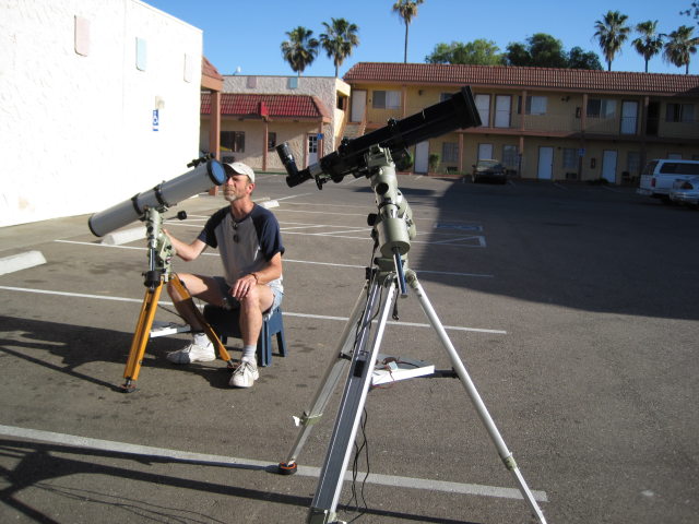
![[ Missing Cape Gooseberry ]](http://shallowsky.com/blog/images/trips/dugup.jpg)
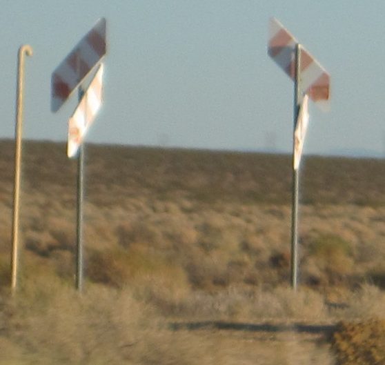